...
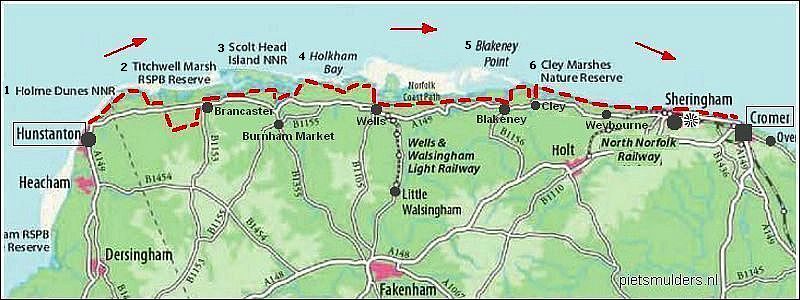
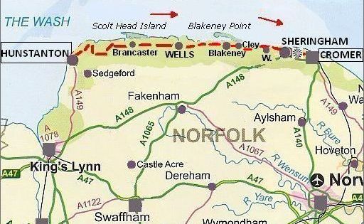
........NORFOLK .COAST .PATH
........ Hunstanton – Cromer = 75 km
Norfolk Coast is
beaches, dunes and saltings (=kwelders):
![]() Alleen aan het begin en einde van de route is een lage klifkust (10 - 20 m).
Alleen aan het begin en einde van de route is een lage klifkust (10 - 20 m).
![]() De rest ( het merendeel ) is een vlakke kust met:
De rest ( het merendeel ) is een vlakke kust met:
1. wide, sandy beaches backed by dunes,
2. many
saltmarshes (=kwelders) riddled with creeks,
3. fresh marshes (=reclaimed saltmarshes)
(d.w.z. ingedijkte kwelders, waar nu vee graast,
4. vast
tracts of mudflats (wadden),
5. a constantly shifting shingle bank (kiezelwal) Blakeney Point with the largest seal colony in England and a tern colony.
6. some brackish lagoons and reedbeds (rietvelden).
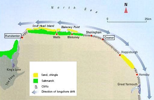
![]() There are 6 nature reserves (see map above) of which 3 important ones:
There are 6 nature reserves (see map above) of which 3 important ones:
1. Scolt Head Island NNR (NNR = National Nature Reserve).
This is a barrier island (=barrière-eiland) with a complex sequence of
shingle banks (kiezelwallen) and dunes.
(De wandelroute komt hier echter niet).
2. Holkham NNR,
3. Blakeney Point NNR (a shingle spit (kiezel-schoorwal) with
seals and
terns.
![]() Here and there a church tower or a picturesque windmill breaks the
skyline.
Here and there a church tower or a picturesque windmill breaks the
skyline.
![]() Numerous
picturesque villages, which were once busy ports, are
now separated from
open water
by saltmarshes and mudflats. Their small harbours are nowadays 'sea' at high tide, and mudflats (wadden) at low.
Numerous
picturesque villages, which were once busy ports, are
now separated from
open water
by saltmarshes and mudflats. Their small harbours are nowadays 'sea' at high tide, and mudflats (wadden) at low.
• Overy Creek and Burnham Overy Staithe.
• Although it was once a busy little port, it is today linked to the sea only by a sandy creek running between saltmarshes (kwelders). The sea can only be reached along meandering
mud channels (geulen) at high tide (hoogwater). Commercial shipping has been replaced by yachts.
Norfolk Coast Path:
![]() Deze national trail volgt nauwgezet de kustlijn. Het is dus een
écht kustpad.
Deze national trail volgt nauwgezet de kustlijn. Het is dus een
écht kustpad.
![]() Kliffen zijn er alleen bij het begin en het einde van de trektocht.
Kliffen zijn er alleen bij het begin en het einde van de trektocht.
![]() Het grootste deel van het Norfolk Coast Path gaat over: lage zeedijken, brede
stranden, duinen en langs een
kilometerslange kiezelwal.
Het grootste deel van het Norfolk Coast Path gaat over: lage zeedijken, brede
stranden, duinen en langs een
kilometerslange kiezelwal.
![]() Bij de lage zeedijken loop je veelal over een breed pad boven op
de kruin.
Bij de lage zeedijken loop je veelal over een breed pad boven op
de kruin.
Zo'n dijk is niet te vergelijken met de hoge zeedijken aan de Nederlandse
Waddenkust. De dijk in Norfolk is veel lager en begroeid met ruigtekruiden.
Zowel de dijk als het landschap eromheen zijn veel
mooier dan dat
in
Nederland.
![]() De buitendijkse saltmarshes (=kwelders) zijn zéér
gevarieerd.
De buitendijkse saltmarshes (=kwelders) zijn zéér
gevarieerd.
Dit geldt ook voor de binnendijkse poldertjes (de ingedijkte kwelders).
Nu eens zie je in de kwelder een bloemenzee, dan weer
een brede kreek.
En in de binnendijkse poldertjes ruig weiland en fresh marsh
(zoetwatermoeras).
![]() Verder zuidwaarts zie je altijd wel weer een dorpje (al of niet met windmolen. En overal vogels (een verrekijker is een must !).
Verder zuidwaarts zie je altijd wel weer een dorpje (al of niet met windmolen. En overal vogels (een verrekijker is een must !).
Mooie samenvatting route Norfolk Coast Path:
www.contours.co.uk/walk...
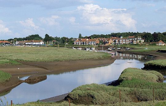
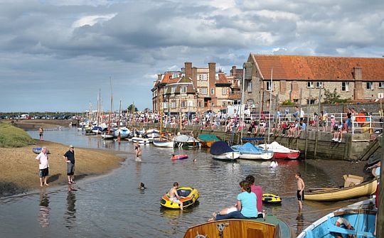
• Standing on the sea wall (zeedijk) and looking to Wells-next-the-Sea.
• Although coasters no longer call at the quay and the fishing fleet is reduced in size, Wells still has a bustling quayside and the harbour continues to provide shelter for fishing boats and yachts.It only remains open because of repeated dredging (uitbaggeren).
• This is one of these small harbours, which are 'sea' at high tide (hoogwater), and tidal flat
(=wad)
at low tide.
• The town is now a mile from the open water
(Wells-on-Sea is verleden tijd, het is nu geworden Wells-next-the-Sea).
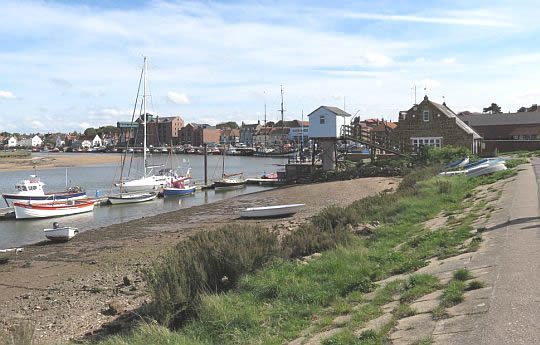
• The beautiful seaside town of Wells-next-the-Sea, comprised of stately Georgian houses and a small harbour.
• On the left is the famous landmark (=markant object), a large green-painted granary with loading gantry, which was built around 1905. This granary has now been turned into luxury flats. The town once boasted over a dozen granaries and maltings, but today only this one is left.
• The quay is still used by some fishing boats that you can see unloading their catch.
Fotoalbums:
www.flickr.com/pho...
....................................
JordanWalks de tweede helft van de foto's (eerste helft zijn Peddars Way)
Begin- en eindpunt:
Van Hunstanton naar Cromer.
Lengte en tijdsduur: 75 km
• Als je deze wandeltrektocht met een lichte dagrugzak loopt , terwijl je de hoofdbagage laat bezorgen,
heb je voor dit traject 4 dagen nodig
(zie verderop
bij Van dag tot dag).
• Ga je echter met trekkingrugzak en tent dan heb je zo'n indeling niet
nodig.
Je bent dan vrij in doen en laten en kunt 's avonds altijd wel een
tentplek
vinden.
Je hebt dan wel ± 1 dag méér nodig, omdat je met
een trekkingrugzak minder
kilometers per dag aflegt.
Beste periode: Juni, juli, augustus.
Mei is nog tamelijk koud.
September is minder geschikt om te kamperen, want:
1.
's morgens droogt je tent niet meer op voor 10.00 uur, zodat je ze nat moet inpakken.
2.
koude dagen behoren in september al tot de mogelijkheden.
3. 's avonds is het dan al vroeg donker.
Hier in Oost-Engeland regent het weinig (zie tabel).
Extra fraai zijn de kwelders in begin augustus tijdens de hoofdbloei van Lamsoor.
(Voor het weerbericht ga je naar www.metoffice.gov.uk/)
.Climate – Norfolk |
mei |
jun |
jul |
aug |
sep |
okt |
.Gemiddelde maximumtemp. °C |
16
|
19
|
21
|
21
|
19
|
15
|
.Maandsom neerslag (mm) |
44
|
50
|
55
|
59
|
54
|
57
|
| ( Gem. maximumtemp. De Bilt ) | 18 | 20 | 23 | 23 | 19 | 15 |
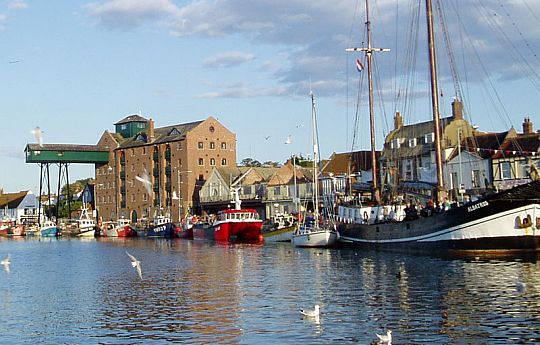
• Blakeney Quay is midden in de zomer een vrolijke boel.
• The harbour and surrounding saltmarsh is now owned and managed by the National Trust and has been allowed to silt up (dichtslibben). This allows only smaller boats access to the harbour from the sea, but providing the perfect natural habitat for coastal wildlife.
• Crabbing from the quayside is a popular pastime. (Je ziet daar een aantal mensen zitten. Ze hebben een vislijn zonder haakje. Ze binden er bacon aan en vangen zo krabben.)
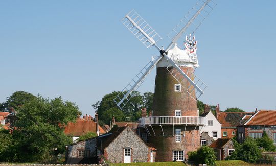
• The chief landmark (=markant object) in Cley-next-the-Sea is its restored 19th century windmill. It has been converted into a holiday home.
Zwaarte:
Lichte wandelingen.
Er zijn geen noemenswaardige hoogteverschillen en overal goede paden.
Zelfs de shingle bank (kiezelwal) was geen probleem, omdat er
aan de
zeezijde halverwege
de talud een enkele meters brede zandstrook was,
waarop
je
heel
goed kon lopen. Zelfs de kruin had hier en daar een smal
paadje. Dat is
uniek.
Dat heb ik nog nooit eerder gezien boven op een shingle bank.
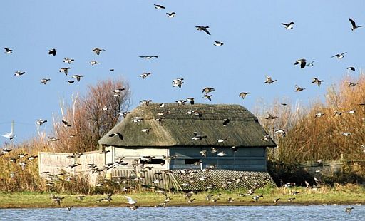
De ultieme vogelkijkroute; denk aan verrekijker !
• Je wandelt door een aantal zéér vogelrijke natuurgebieden.
• Wil je genoeg tijd hebben voor het vogels kijken,
neem dan wat minder kilometers per dag, bijv. het schema van www.hfholidays.co.uk (zie achteraan bij Van dag tot dag).
• Dit langeafstandspad lijkt mij ook heel geschikt voor vogelaars met een mountainbike. Je fietst dan enkele minuten en stopt bij een goed vogelkijkpunt.
• The
marshes at Titchwell and Cley are the best places to see birds
because
they’re set up to allow visitors access to the birds without disturbing
them or
the
sand dunes.
Routemarkering:
Zeer goed, zoals alle national trails.
For much of it you follow clear tracks on top
of the sea bank (zeedijk) or along the edge of the saltmarsh (kwelder) , while the route along beach and
shingle bank (kiezelwal) is equally obvious.
Simply keep the sea on your left all the way to Cromer.
Bevoorrading:
• Levensmiddelen: Hunstanton, Burnham Deepdale, Wells, Blakeney,
Sheringham en Cromer. Dus je komt iedere dag minstens langs één
supermarktje.
• Drinkwater: Er zijn voldoende dorpjes/huizen onderweg.
Wandelbus:
De Coast Hopper rijdt heen en weer langs de dorpjes. 's Zomers iedere
half
uur.
De bussen kunnen overal worden aangehouden ('hail and ride') zolang
het
maar
veilig is om te stoppen.
Zie: www.coasthopper.co.uk o.a. voor de timetables
(Ook bij de TIC's kun je er een halen).
Je kunt dus bijvoorbeeld meerdere dagen in 1 plaats overnachten en van
daaruit
met de bus naar je wandelstartpunt reizen. Goede overnachtingsplaatsen
zijn:
Brancaster Staithe, Wells-next-the-Sea en Cley-next-the-Sea.
ANWB Campings:
Zie voor een overzicht anwb.nl/engeland
Wildkamperen (bivak):
Gaf mij geen problemen.
Denk eraan dat je een tent meeneemt die behoorlijk windvast is.
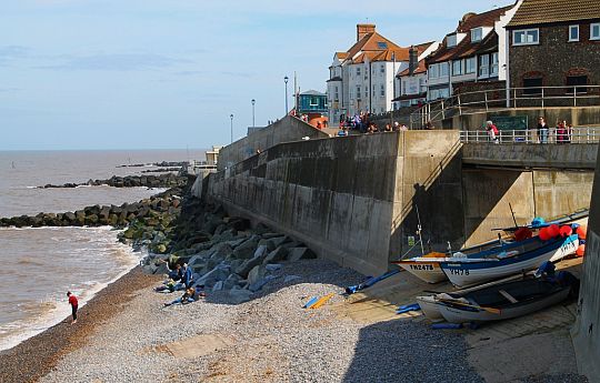
• Sheringham: shingle beach (kiezelstrand) and sea wall.
• Fishing boats are drawn up on the beach below the promenade at Fishermen's Slope.
Hoogtepunten:
• Kliffen bij Hunstanton en Sheringham,
• Holkham Bay,
• boat trip Blakeney Point
(The four miles of coast at Blakeney Point offers uninterrupted views
of the coastline and a seal population across the Blakeney Point NNR).
• Mooie kustplaatsen, o.a. Brancaster, Wells en Cley.
• Burnham Deepdale―Wells-next-the-S. 18 km
• Cley-next-the-Sea ― Cromer = 23 km
(Maar liefst de de helft van de hele route is volgens www.ldwa.co.uk hoogtepunt.
Dat is een mooie score!)
Beware of unstable cliffs/falling rocks:
Een klein gedeelte van de route gaat over kliftoppen.
Op een aantal plaatsen nadert de terugwijkende klifrand daar tot op een meter
het pad.
Dit kan gevaarlijk zijn,
indien de klif op die plaats ondermijnd
is.
Het overhangende gesteente zou dan kunnen afbreken en omlaagstorten.
Daarom geldt als regel:
• blijf boven op de klif op ruime afstand van de klifrand en
• beneden op het strand ook ver van de voet van de klif.
www.bbc.com/news/uk-eng...
www.bbc.com/news/uk-eng...
Extra dagen mogelijk in:
1. Hunstanton:
In this large seaside town are a range of interesting locations to visit, including Hunstanton Lighthouse and Shipwreck at St Edmund’s Point or the
splendid Boston Square.
From Hunstanton Prom, you can marvel over Hunstanton’s famous cliffs,
while,
if
you journey to the outskirts of Hunstanton, you can visit
Sandringham Estate,
the country retreat of The Queen.
2. Wells-next-the-Sea:
This small seaside town is framed by tranquil woodland and has beautiful
Georgian buildings, narrow streets and
golden,
sandy beaches.
A boat trip can be taken out from Morston Quay to Blakeney Point to see the
seals
and tern colony at Blakeney Point.
Then have a picnic and walk back along the
beach to Cley.
• Top-Tour 29 uit de nieuwe Rother Wanderführer England Ost. Ze heet Kelling Heath und Sheringham Park.
3. Cromer:
This large seaside town has a famous pier and
a tradition of RNLI service
and
Life Boat Museum.
The Blue Flag beaches,
the tallest church in Norfolk and an attractive seafront,
make it a great choice for
an extra night.
(For a longer walk, there’s a new extension from Cromer to Sea Palling.)
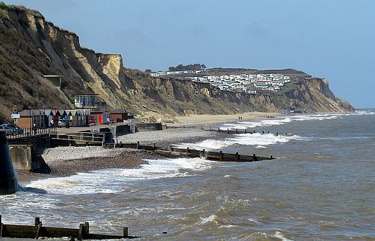
• Cromer, the view west with a caravan park on the clifftop.
• Groynes (=strandhoofden) have been constructed along the beach to trap sediment being carried by longshore drift, and broaden the beach.
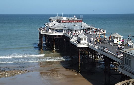
• Cromer Pier is a fitting end point to the walk.
Zie voor een goede introductie van de verschillende kustvormen:
engeland_coastal-lands...
Leuke info over de geschiedenis van de kuststrook:
Ga daarvoor naar:
www.channel4.com/m...
Eindbeoordeling:
Dit langeafstandspad is een echte top trail.
Ondanks dat je niet veel kilometers kliffen hebt, is dit een erg
mooie route.
Beste websites:
www.nationaltrail.co.uk...
.........................................
www.contours.co.uk/w...
........................................
www.norfolkrcc.org.uk/...
..........................................
https://en.wikipedia.org...
Sites komen en gaan; dat valt niet bij te houden.
Googel daarom ook een keer naar norfolk coast path en bekijk de eerste
10 (evt. 20)
resultaten.
Daar zitten de belangrijkste sites wel tussen.
| aaaa |
De zee neemt en de zee geeft .
(kusterosie en - sedimentatie):
Kusten zijn altijd in beweging. Ze kunnen afslaan of aangroeien.
(Ze kunnen ook stabiel blijven, maar dat is uitzonderlijk. Stabiliteit is
meestal te danken aan de mens, die strandhoofden aanlegt en zand
spuit).
The position of the coastline is constantly changing.
1. In places land is being lost to wave erosion.
2. Along other parts of the coast land is being gained by deposition (sedimentatie).
Between the two, waves are transporting eroded
materials by longshore
drift (kustdrift).
.
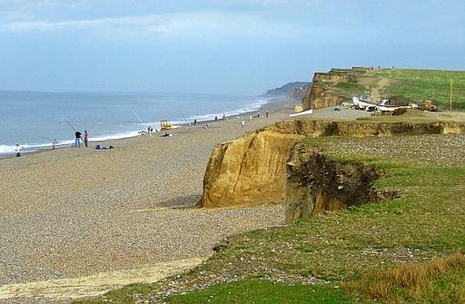
1. Area of erosion: the low, crumbling cliffs (hier dus kustafslag)
• The main sections with cliffs are shown in the map below.
• Those near Hunstanton are sandstone capped by chalk(= krijt). Dit is relatief zacht materiaal , dus sterke erosie.
• Those on both sides of Cromer are glacial till (boulder clay) (= keileem ; grondmorene). This is the so called Cromer Ridge.
Dit is een beboste morenewal die tussen Cromer en Holt ligt.
Diverse gletsjers hebben hier lange tijd hun eindpunt gehad, waardoor veel.materiaal zich kon ophopen. De aldus ontstane rug is meer dan 100 m. hoog en bestaat uit materiaal variërend van klei tot rotsblokken.
Boulder clay is susceptible to erosion as it is weak in relation to other
rocks.Wave action easy removes the clay. The larger stones then
tumble down due to their weight.
2. Area of deposition (=sedimentatie): the coastal plain (hier dus kustaangroei)
• Sedimentatie vindt plaats bij het grootste deel van dit pad, het hele middengedeelte. Hier hebben we een kustvlakte met:
- brede stranden en daarachter duinen,
- wadden en kwelders,
- een barrière-eiland (Scolt Head Island) en
- een lange shingle spit (kiezel-schoorwal) bij Blakeney.
• A study of beach deposition reveals a change in direction of the .longshore drift (kustdrift) west of Sheringham (see map).
The effects of big waves hitting the coast from the dominant northerly
and .north-easterly directions is thought to be responsible for causing
the local.direction of the littoral drift (kustdrift) to go from east to
west towards .the Wash , contrary to the national trend.
| aaaa |
Low (10-20 m), striped cliffs in Hunstanton.
• The cliffs are every bit as striking as they look here on the photograph.
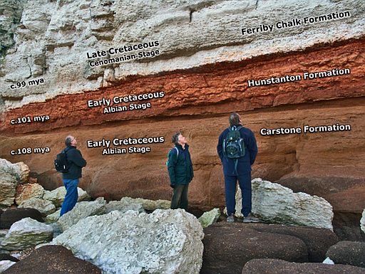
• There are three different coloured layers of rock, known as Carstone, the Red Chalk and the White Chalk(chalk = krijt).
• They were formed when prehistoric seas covered North Norfolk between 70 and 125 million years ago.
Sediments formed layers on the sea bed and slowly hardened into rock.
• Millions of years later, huge earth movements slowly lifted the hardened layers of rock to form land.
• Most recently the sea has eroded away the cliffs to expose a layer-cake of rocks in the cliffs.
1. Carstone:
This is a sandstone and contains many small pebbles (grind) which
rolled around
on the ancient seafloor.
It is rusty brown because it contains a lot of iron oxide - literally rust. Carstone has been used as a building material for houses.
2. Red Chalk:
The sea level rose and the Red chalk (=Rood krijt) , a limestone (=kalksteen), was deposited on the top of the Carstone.
The Brick-Red chalk is a rare rock and Hunstanton is one of the few places it is found.
Look for its distinctive knobbly pebbles on the beach - some containing fossil shells, belemnites and Y-shaped shrimps burrows.
3. White chalk is a limestone and comes from the bed of a warm, clear tropical sea when Hunstanton had a climate like the Bahamas.
It is mostly made of the remains of billions of tiny plants and animals - actually prehistoric plankton !
• Both the Red Chalk and the White Chalk are types of limestone, the
colour of the red chalk is due to staining with iron.
• As both contains fossils the beach below is a magnet for fossil hunters.
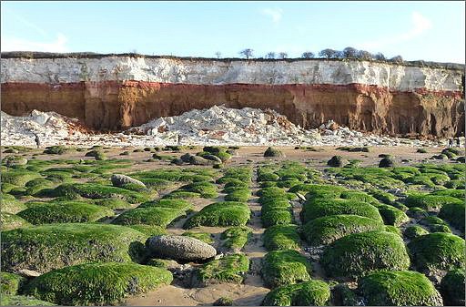
• Wave-cut platform (=brandingsplatform) and Hunstantons eroded cliffs.
• Visitors examine the geology in the striped cliffs (multilayered cliff-face (klifwand).)
• Hier heb je een terugwijkende klif: the Chalk (krijt) collapses as the cliff is undermined and topples as large
blocks.
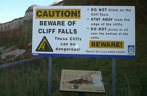
• Beware of cliff falls ! .
• Huge sections of cliff face (klifwand) regularly crack off and fall onto the sand
below, so keep a safe distance.
| aaaa |
Limestone areas in England and Wales:
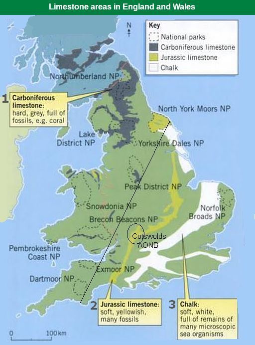
• There are three types of limestone in the British Isles, but the one that
forms
the
highest upland areas is Carboniferous limestone (kalksteen uit
het Carboon).
• Links van de diagonale lijn liggen de uplands (gebieden hoger dan ongeveer
1,000 feet).
• Dus in Engeland zijn de belangrijkste upland limestone landscapes:
Northumberland NP , Lake District NP , Yorkshire Dales NP , North York Moors NP en Peak District NP.
• Je ziet dat North York Moors NP wel uplands is, maar geen Carboniferous limestone heeft, In plaats daarvan
heeft ze de zachte, geelachtige. Jurassic limestone. Deze Jurassic limestone vormt een 500 km lang massief tussen Lyme Regis aan de zuidkust en Whitby aan de noordoostkust.
Ook de Cotswolds heeft die zachte, geelachtige kalksteen. De Cotswolds is echter geen upland (=land lying above the limit of enclosed farmland). Die grens ligt gewoonlijk op grofweg 1,000 feet (± 300m) boven
zeeniveau.De Cotswolds blijft daar grotendeels onder.
The map shows the 3 sedimentary rocks that are made from sea
creatures:
1. Carboniferous limestone (=kalksteen uit het Carboon: hard, grijs),
2. Jurassic limestone (=kalksteen uit de Jura: zacht, geelachtig) and
3. Cretaceous chalk (=krijt uit het Krijt: zacht, wit) ,
Cretaceous chalk (3) and Jurassic limestone (2) can hold water – they have tiny holes in them
and are very porous.
Carboniferous limestone
Carboniferous limestone is not at all porous — although it is permeable (= doorlatend). It allow water to pass through it from one pore space
to another by capillary action or along cracks (barsten) and fissures (spleten).
A long time ago, about 350 million years ago (even before the Dinosaurs) England was covered by a
shallow tropical se – a bit like
where the Great Barrier Reef is forming today.
As the small animals and corals that lived in the sea died, their shells and skeletons fell to the bottom. A thick layer built up over millions of
years.
As it squashed and hardened, it eventually turned into limestone.
This Carboniferous limestone is nowadays found in:
- northern
England (e.g. Yorkshire Dales, Peak district),
- Wales (e.g. Brecon Beacons) and in
- Ireland (e.g. The Burren).
| aaaa |
Muren van brick-and-flint:
• Opvallend in Norfolk zijn de vele gebouwen waarin vuursteen (flint) verwerkt is.
• De hoekstenen bestaan uit baksteen (brick) met daar tussenin een grillige
hobbelstructuur van afgeronde cobble flints (vuursteen-rolstenen). Hier aan de kust liggen deze op de stranden
voor het oprapen.
• Flints which have been washed out of the chalk cliffs can be found on the beach as rounded cobbles (afgeronde rolstenen) and have been used. extensively for building in
Norfolk.
• Early flint buildings are generally built of the unprepared cobbles mortared. together.
Later brick or stone details for corners or door and window frames are introduced.
• Knapped flints are cut, initially using a six pound hammer, and then
with. smaller ‘flat’ hammers to reveal the interior black surface.
• They were much used in 15th century East Anglian churches.
• Knapped square flints need less mortar, resulting a stronger construction.
https://toffeefee.wordpress.c
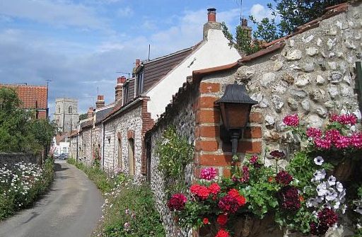
• Flint-built cottages in Brancaster.
• Bij de huizen bestaan de hoekstenen uit baksteen met daar tussenin een grillige hobbelstructuur van door de zee afgeronde vuursteen-rolstenen.
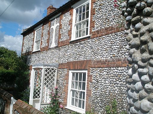
• A house in Cley-next-the-Sea.
• Knapped square flints.
| aaaa |
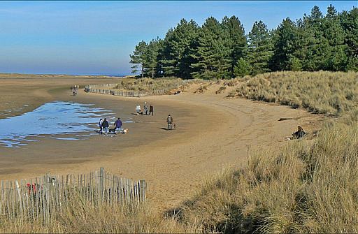
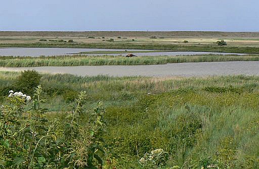
Saltmarshes (=kwelders)
Kwelders zijn begroeide stukken land die direct aan zee grenzen.
Ze liggen meestal langs ondiepe getijdengebieden.
Ze komen bij
extra hoge waterstanden (springtijden en stormvloeden)
onder water
te staan.
Met het zeewater meegevoerde zand- en slibdeeltjes komen tussen
de
planten terecht en spoelen niet meer weg.
Door deze opslibbing worden kwelders geleidelijk steeds hoger.
Zo wordt het een goede stek voor kweldergras.
Kweldergras kan nog beter dan zeekraal zand en slik vastleggen.
Als een kwelder nog maar een paar keer per jaar onderloopt, ontstaat
een
min of meer stabiele begroeiing met zout verdragende planten
als Lamsoor, Zeealsem , Gewone zoutmelde en Zulte.
• Saltmarshes (=kwelders) fringe much of the north Norfolk coast between Holme-next-the-Sea and Cley-next-the-Sea, a distance of
35 km.
In places the belt of marshes is more than 2 km wide, and the total area of saltmarsch exceeds 3000 ha.
• In addition, there are approximately 6000 ha of mudflats (=wadden) exposed at low tide and
• more than 1500 ha of fresh and brackisch marshes (polders) which
have
been
reclaimed from the sea (ingepolderd) by building of embankments (lage zeedijken) since the
mid-seventeenth century.
They are maintained mainly by seasonal grazing, principally by cattle.
Some are arable farmland and some reed bed (rietveld).
• Saltmarshes and mudflats arise where high tides occur in areas of extremely low wave energy, such as behind barrier islands or spits, in bays or at the top
of long, flat beaches.
These very low energy conditions allow seawater to deposit the tiniest, lightest clay particles.
• The marshes are still accreting (=opslibben) at an average rate
over the
whole marsh of 2.5mm per annum, fed by the rich supply of
sediment from
the shallow offshore waters.
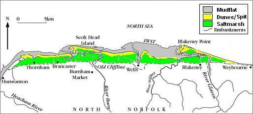
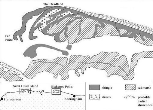
• The saltmarshes (groen) developed in the lee of dunes, barrier island and spit (geel).
• Dit kaartje is de toestand van voor de inpolderingen.
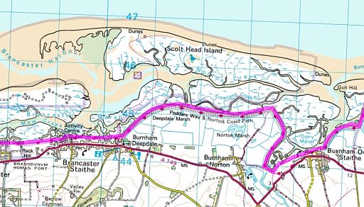
• De kuststrook bij Scolt Head Island.
• De magenta streep is de lage zeedijk met daarop het Norfolk Coast Path.
• Men heeft in Norfolk relatief veel oppervlak aan kwelder (wit) en weinig aan wad .(bruin).
• De strook tussen het barrière-eiland en het vasteland is slechts enkele kilometers breed.
Hierboven zie je een stukje van de kuststrook bij Scolt Head Island.
Er zijn enkele duidelijke verschilpunten met de Nederlandse Waddenzee:
1. In North-Norfolk is er relatief veel oppervlak aan kwelder en weinig wad. Bij de Waddenzee in Nederland is dat andersom.
2. De strook tussen het barrière-eiland en het vasteland is hier in Norfolk slechts enkele kilometers. Bij de Waddenzee in Nederland is die vele kilometers. De afstand tussen bijv. Terschelling en de Friese Zeedijk
is wel 10 km.
... mudflat. = wad saltmarsh. = kwelder |
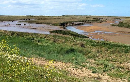
• Saltmarsh (kwelder) south of Scolt Head Island, seen from the low sea wall (zeedijk).
| aaaa |
Holkham NNR . (Natural Nature Reserve):
Holkham NNR is the largest coastel nature reserve in England with more than 600 hectares of varying coastal habitat.
• From Burnham Overy to Wells the lowlying marshes north of the coast road used to be saltmarshes (kwelders).
• The tidal creeks were large enough to allow ships to load cargo from a staithe at Holkham village.
• From 1639 onwards a series of embankments (lage zeedijken) were
constructed by local landowners.
By 1859 when the Wells embankment was completed about 800 hectares of saltmarsh had been converted to agricultural use.
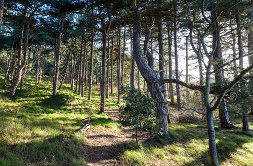
• In the middle of the nineteenth century, pine trees were planted on the dunes, creating a shelter-belt to protect the reclaimed farmland from windblown sand. Today the ribbon of mature pinewoods still separates seascape from farmscape.
• Across the coast road is Holkham Hall, a Palladian style mansion (herenhuis).
The hall is set in large parkland, full of nature trails
and marked walks.
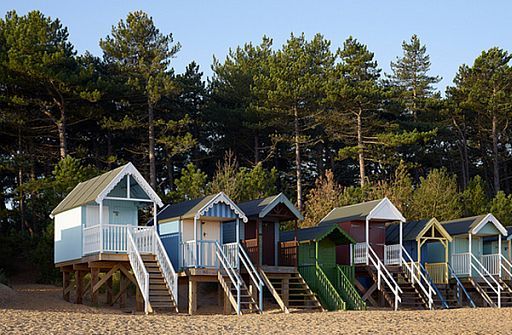
• A row of colourful beach huts (strandhuisjes) in front of the shelter-belt of Corsican pines. These pines were planted in the 1860s to protect the newly reclaimed farmland from windblown sand.
• The beach huts are on stilts to protect themselves against flooding.
• Links, net buiten de foto, is een heel groot zandstrand.
• De duinen liggen boven op een kiezelwal. Ze zijn begroeid met Helmgras en dennen.
• The dunes were stabilised by pine plantation in the 19th century.
• They used three varieties of pines:
1. Corsican Pine (= Corsicaanse den) :
.... grijze stam ..en.. kleine kegel.
2. Scots Pine (=Grove den) :
.... bovenste deel stam oranje
3. Maritime Pine (=Zeeden) :
.... grote kegels in groepjes
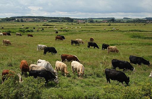
• Fresh and brackisch marshes( polders ) which have
been
reclaimed from the sea (ingepolderd) by building of embankments (lage zeedijken) since the
mid-seventeenth century. They are maintained mainly by seasonal grazing,
principally by cattle.
Zie verder: Holkham NNR.
| aaaa |
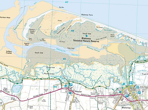
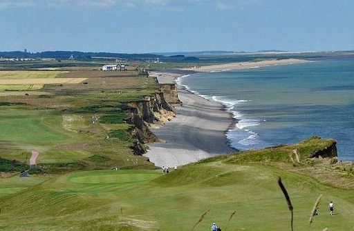
Blakeney Point is a shingle spit (kiezel-schoorwal)
.
• Blakeney Point is a spit as it is attached to the cliffs at Weybourne Hope.
• These cliffs are the main sediment source for this some 10 km long
spit. Material eroded from the cliffs is carried westwards bij longshore drifting.
• The spit is composed of a shingle bank (kiezelwal) , which is about
200 meters in width and about 10 metres in height.
• At the western end the shingle curves back landwards forming distinctive lateral ridges or fingers. (Het uiteinde van de schoorwal is haakvormig gebogen).
The three main habitats are:
1. Shingle (=kiezelsteen)
The shingle is coarser at the eastern end compared with the material
further west.
This occurs because as the material is being moved the
particles can
rub together and break apart.
Also the waves would be able to carry smaller particles further because
they take less energy to move.
2. Dunes have built up on the shingle ridge near the headland.
They have classic examples of plant succession occurring on them.
Towards the sea there are embryo dunes, which are tiny dunes that
have
been made by the wind depositing sand in sheltered areas such
as
behind driftwood.
These then build up into the main ridge otherwise known as yellow dunes. These dunes tend to have a high percentage cover of
vegetation because
they are more sheltered and the roots of the plants
can have a wide area to spread around.
Next are the grey dunes, these dunes having a diverse number of
species;
this is because the sand is slowly turning into soil because
when
the pioneer species die they put nutrients and minerals into the
soil, this
is called humus. Also the land is very sheltered by the main
yellow dunes enabling less xerophytic plants to survive there.
One of the pioneer species is Marram grass (=Helm). This has adapted
well
to the harsh conditions. The grass has a thin low surface area to
reflect the heat meaning less moisture lost and the roots of the plant
spread out very
far so the plant can be anchored in place.
The combination of sand dunes and Marram grass is very effective as a
sea protection because it absorbs the energy of the waves well.
3. Saltmarsh(=kwelder) have developed between the arms of the lateral ridges and the low energy area between the spit and the old coastline. It is obvious that the two main plants that do well in this area are Spartina (Slijkgras geslacht) and Salicornia (Zeekraal geslacht).
...spit .= schoorwal |
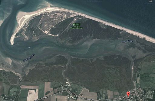
• Recurved spit (=gebogen schoorwal).
• Blakeney Pit en Blakeny Channel zijn channels (=geulen).
• De waterlopen op de kwelder vlak bij het Norfolk Coast Path zijn creeks (=kreken).
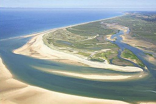
• Blakeney Point, the sand spit which has the largest seal colony in England.
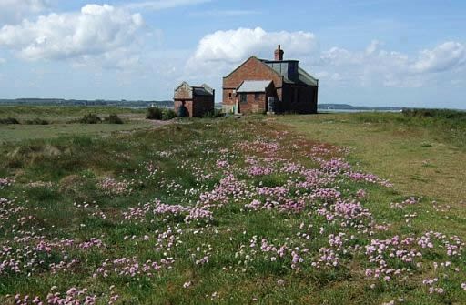
• Blakeney Point, the watch house.
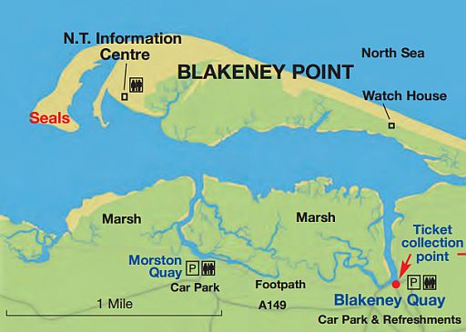
• No finer trip exists in East Anglia then to take a boat trip out from
Morston Quay to
Blakeney Point to see the hundreds of seals and a tern colony.
After that have a picnic and walk back along the beach to Cley.
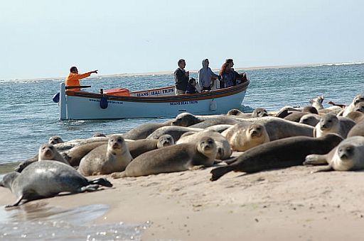
• The seals bask at high tide (hoogwater) on the sand-bars and are viewed from the boats.
• They are a mixture of
Common seals (Gewone zeehond) and Grey seals (Grijze zeehond).
| aaaa |
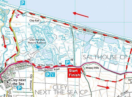
Tour 30: Cley und Salthouse Marshes .. 2.15 uur
.
The beach at Cley is part of the shingle spit which extends for some
10 km
from Weybourne to Blakeney Point.
But what makes this section so special is the Cley Marshes Nature Reserve, which covers a large area behind the beach.
It is one of Britain's best places for bird watching.
The many hides(schuilhutten) provide spectacular views over pools
and scrapes.
To visit the hides you will first need to purchase a pass from the visitor
centre.
You approach the hides via wooden boardwalks (vlonderpaden, plankenpaden) through the
reeds and
these give you a much closer view of the various pools and
scrapes.
| aaaa |
Low (10-20 m) cliffs in Weybourne Hope and further.
.
At Weybourne Hope there is a very good example of a coastline, which
is rapidly eroding. The shingle beach (kiezelstrand) is here quite steep.
The low cliffs are made from weak glacial deposits known as till or boulder clay (keileem) and are even more crumbling than the cliffs at Hunstanton.
They are about nine meters high. Further to the east they become a
little higher (10 - 20 m).
• Hier bij Weybourne Hope begint opnieuw een aktief klif.
• View eastwards from Weybourne Hope to the steep, narrow shingle beach (kiezelstrand) and intensely eroding cliffs.
• The beach rest against the retreating (terugwijkende) cliff. These eroded cliffs consists of weak unconsolidated boulder clay (=keileem). They are even more crumbling than the cliffs at Hunstanton.
(They erode at an alarming rate of up to 2.5 metres a year).
• View from Skelding Hill to the west to the eroding cliffs and shingle beach.
| aaaa |
Top-Tour 29:
Kelling Heath und Sheringham Park .. 4 uur
Zie voor verdere info hierover de Rother Wanderführer
KAART:
.....
| aaaa |
Van dag tot dag (www.contours.co.uk)
1. Hunstanton ― Brancaster
..... 16 ½ km .... lichte wandeling
( Hunstanton is unique as an east coast resort in that it faces west and
so the sun sets over the sea.)
Leave behind the hustle and bustle of Hunstanton to explore the wilder
side
of the coastline.
The famous low (10 - 20 m) , striped cliffs and pretty beach houses in
Old Hunstanton give way to the Holme Dunes NNR (National Nature
Reserve).
This beautiful area of beaches, dunes, freshwater pools and saltmarsh
provide a wonderful habitat for birds.
The trail turns inland across farmland for a short while as it approaches Brancaster.
2. Brancaster ― Wells-next-the-Sea
.... 19 ½ km .... licht
Here, the remains of the SS Vina can be spotted from the town’s harbour
and
the round Saxon tower of St Mary’s Church can be visited.
Next, the trail passes the Roman Fort of Branodunum along a more wild
section of marshland and tidal creeks on the way to the old seaport of Burnham Overy Staithe where the tiny River Burn reaches the sea.
To the north you see Scolt Head Island NNR.
Continues along mudflats to the beaches of Holkham NNR.
You may see some black peat beds on the beach at low tide.
These are the remains of an ancient forest.
The trail enters pretty Corsican Pine forest and soon arrives at Wells-next-the-Sea,
a
beautiful seaside town.
3. Wells-next-the-Sea―Cley-next-the-Sea
.... 18 km ..... licht
Through the remote saltmarshes to the hamlet Stiffkey.
This delightful hamlet with its flint-walled street deserves more than a
passing glance.
The same can be said
of the hamlet Morston, famous today for its seal
tours.
When the trail reaches the village of Blakeney, lined by flint cottages,
there
is the chance to spot Grey Seals on the saltmarsh and shingle
expanses of Blakeney Point NNR.
The trail then continues to the lovely village of Cley-Next-The-Sea,
a fabulous place to admire the reedbeds of the Cley Marshes.
Land reclamation in the 17th century left the inaptly-named village of
Cley-next-the-Sea a full mile from the shore.
The large scale of 14th century "wool church" of St. Margaret's at Cley
is a reminder of the area's medieval prosperity. The church stands on
high ground above meadows which were once the harbour.
The village is also notable for the large 18th century windmill which
towers over the old quay.
4. Cley-next-the-Sea ― Cromer
..... 21 km ...... licht
Cley Marshes nature reserve gives way to a long shingle bank(kiezelwal).
The shingle bank (which runs from Blakeney Point) ends at Kelling Hard and becomes a shingle beach (kiezelstrand) backed by low cliffs as far
as Weybourne, where the shingle bank(kiezelwal) reappears for about
250 metres.
From Weybourne to Sheringham, glacial deposits form low (10-20 m)
cliffs
fronted by a steep shingle beach.
The low, undulating cliffs are susceptible to erosion and all the way you
can see where whole chunks have peeled off.
They show that the base is chalk overlaid with younger deposits of
sands
and gravels. This is a moraine created in the last ice age.
Walk on the clifftops to Sheringham and then enter developments in the
form of West Runton and East Runton static caravan parks.
You enter Cromer on the cliff face looking down on the Pier and feel a
great sense of achievement !
Wil je wat meer tijd hebben voor het vogels kijken en/of korte
(uitstapjes) te maken
naar gehuchten en dorpjes vlak langs de route,
neem dan liever wat minder kilometers per dag, bijv. het schema van www.hfholidays.co.uk:
1. Hunstanton ― Brancaster ...... 16 ½ km,
2. Brancaster ― Wells-next-the-Sea ... 19 ½ km,
3. Wells-next-the-Sea ― Blakeney ... 13 km,
4. Blakeney ― Weybourne .........13 km,
5. Weybourne ― Cromer ....13 km.
| aaaa |
SNP Natuurreizen heeft in Groot-Brittanië ook wandelreizen:
Hun reizen met een zwaarte van 1 of 2 zwarte cirkeltjes komen het beste overeen met mijn wandelingen.
Je maakt dan niet te veel hoogtemeters en wandeluren per dag.
Zie: www.snp.nl/reizen/
| aaaa |
Twee wandelgidsen nodig: ............. .............. Kaart: .......... Te bestellen bij: Reisboekwinkel de Zwerver (webshop voor reisgidsen en landkaarten) |

..Deze wandelsite is niet-commercieel, onafhankelijk en gratis. Dat is enkel mogelijk door steun van de bezoekers. Uiteraard kun je ook doneren door overschrijving op mijn |
Weet je aanvullingen en verbeteringen van deze tekst?
Graag een e-mail naar:
![]()
![]() ....
.... ![]() ....
.... ![]()
LAATST BIJGEWERKT : 17-1-2019