.
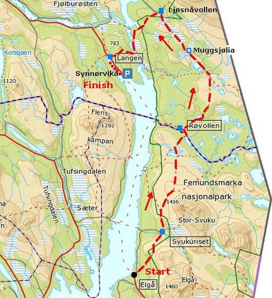
Introduction Femundsmarka National Park:
.
THE GIFT FROM THE ICE:
 With twisted pines and secluded lakes scattered amongst a sea of boulders, the Femundsmarka National Park beckons you to experience it.
Ten thousand years ago, the glaciers retreated (slonken; weken terug) leaving behind a desolate, primeval-like, ice-age landscape – a landscape that has scarcely changed since. With twisted pines and secluded lakes scattered amongst a sea of boulders, the Femundsmarka National Park beckons you to experience it.
Ten thousand years ago, the glaciers retreated (slonken; weken terug) leaving behind a desolate, primeval-like, ice-age landscape – a landscape that has scarcely changed since.
The area has been used by the Sámi people for centuries, but retains its unspoilt character.
Together with adjoining protected areas in Sweden, the Femundsmarka National Park forms part of one of the largest continuous, undisturbed (?) wilderness areas in southern Scandinavia.
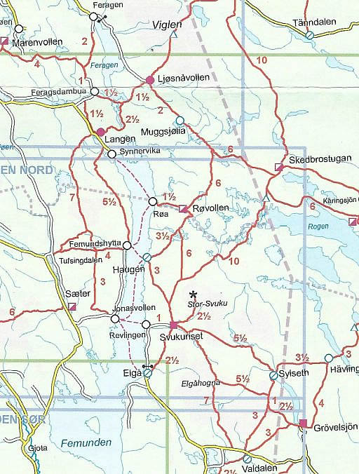
LANDSCAPE AND GEOLOGY:
Barren fells and glittering waters:
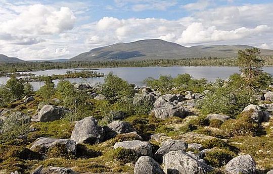
The southern part of Femundsmarka is dominated by stony and bouldery fells. Elgåhogna (1460 m) and Store Svuku (1415 m) are some of the highest tops (zijn kale bergen met een weids uitzicht).
To the north towers Storvigelen, the highest of the mountains, 1561 m above sea level.
Between the high fells, lie forested valleys with countless glittering small lakes, watercourses and pine-clad moraine ridges.
Sculpted by ice:
Large parts of Femundsmarka are a barren, primeval landscape
sculpted
by
the ice that retreated ten thousand years ago.
The area abounds in accumulations of rocks, stones and earth
(moraines)
and large boulders that were carried along and deposited
by the ice.
A distinctive feature is the narrow ridges, called Rogen moraines,
which
curve out into the lakes to form a multitude of promontories
and islands.
Their name derives from the lake on the Swedish side.
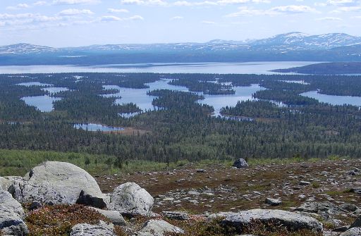
These forested ridges in lake Rogen are glacial landforms, the so-called 'Rogen moraines'. These are also evident around Røvola.
PLANT LIFE:
Mostly poor soil:
The flora in Femundsmarka is quite sparse and the paths are edged with crowberry (Kraaihei) , bilberry (Blauwe bosbes) and
heather.
But there are a few exceptions. Near Røvollen and Muggsjølia are oases. with rich vegetation.(Daar heb je kalkhoudend gesteente!)
Twisted (gedraaide) and weather-worn, old pines Pinus sylvestris (Grove den) are a distinctive
feature of the
national park, giving Femundsmarka a mystic,
fairytale look. The pines grow like this because of the lack of nutrients to be had from the poor bedrock, as well as the dry inland climate with its long, harsh winters.
The pines are
widely scattered, giving an open feeling to most of the park.
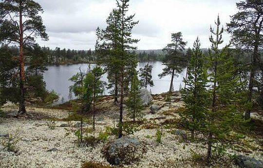
In areas of dry ground, the floor of the Lichen – Scots pine woodland.(Lichenen-Dennenbos) is dominated by sand and gravel, and here the most common species found on the woodland floor are 'reindeer lichen'Cladonia rangiferina (Echt rendiermos) and another lichen, Cladonia stellaris (Stervormig rendiermos).
The Lichen – Scots pine woodland is light and open, and pine is usually the
only type of tree present.
In areas of wetter ground Heather – bog bilberry – Scots pine woodland takes over. Here, bilberries (Blauwe bosbessen), cowberries (Rode bosbessen), heather and some herbs, grasses and mosses
grow on the woodland floor.
There are three kinds of mire in Femundsmarka: peat bog, brushwood bog and sedge fen. They are generally poor in nutrients.
1.The peat bogs are made up largely of Sphagnum moss and cottongrass. They are often found close to small tarns and ponds, and are surrounded by
2. brushwood bogs.
These are
drier and dominated by heathers, dwarf birches and willows.
3.The sedge fens occur on slopes and are characterised by sedges.
Vulnerable plant species:
In Femundsmarka, there are a number of vulnerable species that
require
large areas of pristine woodland. One important species is the
rare wolf lichen, which grows on the trunks and branches of old, dead
pine
trees. One of the most important occurrences in the country can
be
found in the
inner part of Femundsmarka
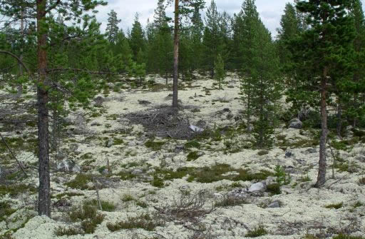
• Echt rendiermos (Cladonia Rangiferina) in open dennenbos.
BIRD LIFE:
The many lakes and wetlands provide valuable nesting and feeding grounds, especially for ducks and waders.
Many ospreys (Visarenden) nest in the national park.Their relatively high numbers are explained by the ready availability of food in the shallow lakes that are so
rich in fish, and the good nesting sites provided by old, flat-crowned pines.
Many pine tree trunks have nest holes made by three-toed woodpeckers (Drieteenspechten) and in autumn Siberian jays (Taigagaaien) hide berries and mushrooms in cracks in the bark.
Golden eagles (Steenarenden), gyr falcons (Giervalken), goshawks (Haviken) and eagle owls (Oehoes) also nest in this area.
ANIMAL LIFE:
The barren landscape does not provide a suitable environment for a rich animal life. Nevertheless, a number of species live alongside the watercourses, some of which are rare, vulnerable or threatened in this part of
the country.
 Wolverines (Veelvraten) are well established, while brown bears and
lynx roam into the park. Wolverines (Veelvraten) are well established, while brown bears and
lynx roam into the park.
A herd of musk ox that has migrated from Dovrefjell also lives here.
Femundsmarka is one of the few places in inland southern Norway where
there is a permanent otter population.
In some of the larger watercourses, there are also clear signs of the presence of beavers, with felled trees and sturdy dams.
The national park is also an important winter grazing area for elk (Eland), which
come in large numbers in winter from the area around Aursunden further to the south. In some places, the pine woodland shows signs of heavy grazing.
The Sámi herd their reindeer in this area.
Elgå is the southernmost Sámi reindeer herding area in Norway.
The reindeer should not be disturbed when grazing and they are especially vulnerable during their calving season.
A small flock of musk oxen are found in the northern part of Femundsmarka around the river Mugga and Mount Skedbrofjellet.
If you meet a musk ox – stay calm and keep a distance of at least 200 m. This is for their safety as well as your own! Musk oxen can charge if they feel threatened.
HISTORY AND CULTURAL HERITAGE RELICS
The first signs of human activity in Femundsmarka date from the
Neolithic (Late Stone Age) period. These include habitation sites and
the remains
of
fairly large trapping systems of pitfalls (vangkuilen).
Central Sámi area:
It is uncertain how long there has been Sámi activity in the area. The Sámi people have herded their semidomesticated (halftamme) reindeer
for centuries and before that they lived by hunting, trapping, gathering and fishing. They have
traditions and beliefs associated with places in the national park, often
without having left any physical traces on the land.
Some of the visible traces in Femundsmarka include old settlements with the foundations of turf huts, various storing places, and corrals where reindeer were gathered together.
A number of settlements were established in the area during the late-18th century.
As time went by, summer dairy farms at Haugen and Svukuriset, just outside the national park, developed into farms, where
people still live.
The Røros Copper Works have left their mark:
Many of the traces from recent centuries left in the area in and around
the national park relate to the Røros Copper Works.
The copper smelter on the western shore of Femunden was in
operation
from 1743 to 1822.
Right up to the Swedish border, there are clear signs of tree felling and charcoal kilns (houtskoolmijten) to supply the furnaces with charcoal.
Along the watercourses, there is evidence
of log floating in the form of
dams, log flumes, timber booms and log raft booms.
(Voor het vervoer van hout werden kanalen gegraven, die voor een
deel
nog steeds te zien zijn.)
|