..
.......... SOUTH . DOWNS . WAY
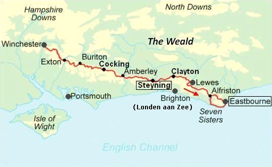
......... Steyning – Eastbourne = 73 km
South Downs National Park:
• Het South Downs National Park is een krijtheuvelrug langs de
Zuid-Engelse kust.
• In het
oosten
eindigt ze met de Seven Sisters abrupt in
zee.
In het westen gaat ze
langzaam over
in de
omringende lage
heuvels.
• Downland (or downs) is an area of open chalk hills (krijtheuvels).
• Naamsverklaring South Downs:
Down beteknt normaliter "beneden". Het lijkt daarom een rare naam voor heuvel, maar het woord gaat terug op het Oud-Engelse 'dün', waar je de verwantschap met ons woord duin (zandheuvel) in herkent.
Het woord South is ter onderscheiding van de North Downs die een
50-tal km noordelijker parallel ermee lopen.
South Downs Way: a chalkland bridleway.
(chalkland = krijtland) (Bridleway = path for foot, bike and horse)
1. Bij de South Downs Way loop je langdurig boven over een cuesta. Ze zorgt voor mooie uitzichten.
2.
The trail also dips (=afdalen) into the beautiful river valleys cutting
through the downs. (die rivierdalen zijn doorbraakdalen) and
3.
visits some very picturesque villages with their thatched cottages and gardens bursting with flowers.
| . . MOOISTE DEEL : .. STEYNING — EASTBOURNE |
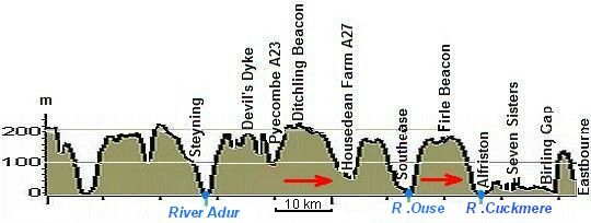
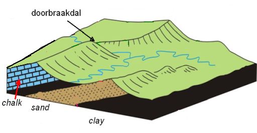
• De voorlopers van de riviertjes Cuckmere, Ouse en Adur hebben diepe dalen uitgeschuurd in de krijtrug (doorbraakdalen!). Hier moet je dus telkens afdalen en weer omhoog klimmen.
.
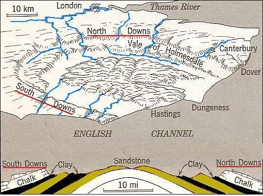
• The Weald region is a broad dome (koepel) of sedimentary strata from which the top has been. removed.
• Let op ! In de dwarsdoorsnede is de koepel sterk overdreven afgebeeld. De lagen hellen in werkelijkheid slechts. enkele graden.
Ontstaanswijze:
• Het zuidoostelijk deel van Engeland werd tussen 100 en 70 miljoen jaar .geleden verscheidene malen overspoeld door een ondiepe zee. Toen zijn er o.a. lagen krijt en klei afgezet. (Krijt is een fijnkorrelige, witte, zachte kalksteen, die uit de skeletten van microscopisch plankton bestaat.)
• Tijdens de alpiene plooiingsfase 60 miljoen jaar geleden, werden die afzettingen opgeheven tot een grote koepel.
• Het bovenste deel hiervan erodeerde later weg. Er bleven alleen de twee randen, de cuesta's South Downs en North Downs over, met daar tussenin een lager liggend tamelijk vlak gebied The Weald.
• De South Downs hebben er vóór de komst van de Romeinen heel anders uitgezien. Hoewel de bodem zeer dun is, stond er toch bos. Wel was het minder dicht dan het bos in de dalen. Die bossen boven op de cuesta waren dan ook gemakkelijker te kappen.
• Sinds de Romeinse tijd was er kruidenrijk grasland, waar tienduizenden schapen graasden.
• Na de Tweede Wereldoorlog verdween veel grasland en werd het akkerland. Gelukkig bleef er grasland langs het pad gespaard.
• Omdat het water wegzakt in de poreuze krijtheuvels, zijn er geen riviertjes die eroderend werken. Het krijt biedt dan ook opvallend veel weerstand aan erosie. Dit verklaart het bestaan van deze krijtheuvels met hun escarpments (scarp slopes)
• Gewoonlijk vertalen we escarpment in het Nederlands door steilrand, maar hier bij cuesta's hebben we in de geologie een eigen woord: cuestafront.
• Diep in de heuvels stroomt het grondwater zijwaarts af over een ondoordringbare kleilaag naar het dal. Daar treedt het uit als een bronnenlijn aan de voet van de krijtheuvel en daar ontstonden ook de dorpjes. (In dit dichtbevolkte deel van Gr.-Brittannië bleef de heuvelrug onbewoond.)
• Wil je nog iets meer lezen over dit gebied klik dan op: www.volkskrantreizen
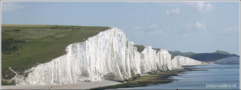
• Het aktieve krijtklif bij het gehucht Birling Gap.
• Het behoort tot de top-10 kwetsbare plekken kustafslag in Groot-Brittannië. Terugwijkende klifrand: hier langs dit deel van de Engelse zuidkust wint de zee gemiddeld liefst 70 cm per jaar aan terrein.
• Chalk (= krijt) is generally considered a soft rock, but it is surprisingly resistant to marine erosion and forms towering vertical cliffs along the coast.
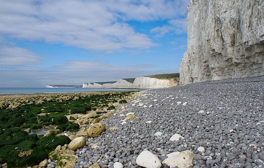
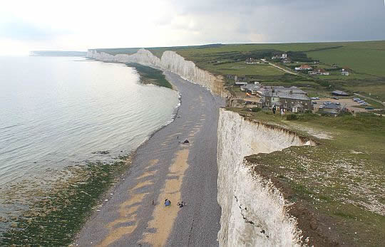
• De Seven sisters in de verte, gezien vanaf het rolsteenstrand. De golvende krijtheuvels zijn kaarsrecht afgesneden door de zee.
• Rechts zie je een brandingsnis. Ze ligt ongeveer op hoogwaterniveau.
• Ervoor ligt een grijze wal van vuursteen-rolstenen met hier en daar een brok krijt). (The grey cobble beach is of rounded flint nodules, speckled with fresher chalk lumps.) Hun ronde vorm kregen de rolstenen bij het heen en weer rollen door de golfslag.
• Links het wave-cut platform (= brandingsplatform).
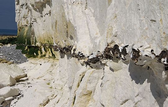
• Een vuursteenband in het aktieve krijtklif van dichtbij gezien.
• (Linksboven in de foto zie je nog een gedeelte van een erboven liggende laag.)
• The white cliffs are made of billions and billions of microscopic plankton, which have slowly compacted into huge beds of chalk (= krijt).
• The chalk contains flint (= vuursteen) which can be seen in bands throughout the rock.
• New and old chalk debris on the beach. The chalk (=krijt) collapses as the cliff is undermined and topples as large blocks.
• Dat dit een aktief klif is, is wel duidelijk op deze foto.
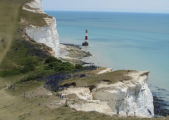
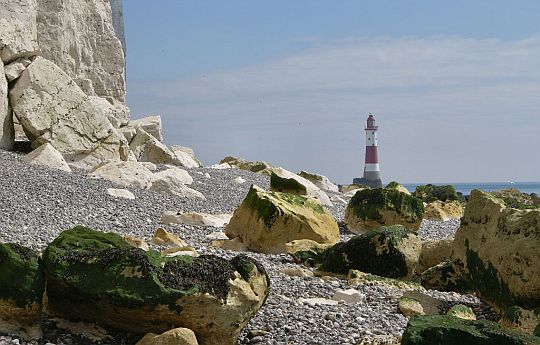
• The view to the lighthouse from the clifftop.
• De vuurtoren staat op het brandingsplatform.
• De erosie houdt de krijtrotsen vers en wit. Het is een aktief klif. (Als het klif inaktief zou zijn, zou de krijtrots groen worden.)
•. Door de klimaatverandering vindt er tegenwoordig een versnelde afbrokkeling plaats. Jaarlijks verdwijnt hier gemiddeld zo'n 70 cm rots in zee.
Fotoalbum:
http://ramblingman.org...
...........................................
www.southdownsway.co.u...
Door mij gelopen deel:
Van Eastbourne naar Steyning (dus van oost naar west).
- Eerst liep ik over de "Seven Sisters" (sea cliffs), daarna landinwaarts boven over de escarpment (het cuestafront).
- Het eerste stuk tot Westdean was erg druk; naast wandelaars waren er ook nog mountainbikers. Daarna werd het rustig.
Belangrijk ! : Loop deze route liever in omgekeerde richting.
Begin dus in Steyning en kom vier dagen later aan in Eastborne. Het meest bijzondere gedeelte (Alfriston—Eastbourne) komt dan het laatst.
Lengte en tijdsduur: 73 km
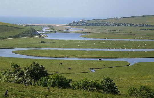
• Het Cuckmere-dal is een van de vier doorbraakdalen.
• The River Cuckmere is tidal up to four miles upstream, and, as a result, is a good place for bird watchers with its range of habitats including coastal lagoons.
• De rivier de Cuckmere meandert over de brede, vlakke dalbodem naar zee.
• Een meander is een min of meer regelmatige bocht van een rivier.
In de buitenbocht vindt erosie plaats (spoelt grond weg) en ontstaat daardoor een rivierklif.
In de daaropvolgende rustige binnenbocht vindt sedimentatie (afzetting) plaats en ontstaat daardoor een rivierstrand. (Dus bij een meanderende rivier hebben de opeenvolgende bochten invloed op elkaar.
Een buitenbocht erodeert almaar verder, en het sediment belandt deels in de volgende binnenbocht, die zich daardoor verder naar binnen verlegt.)
• Deze foto toont de kenmerken van een rivierdal in z'n benedenloop:
1. zéér breed dal (overstromingsgebied)
2. grote meanders (en ook afgesneden meanders).
(Alleen het derde kenmerk (de oeverwallen) zijn op deze foto niet zichtbaar.)
....Bar (= Nehrung (Duits) |
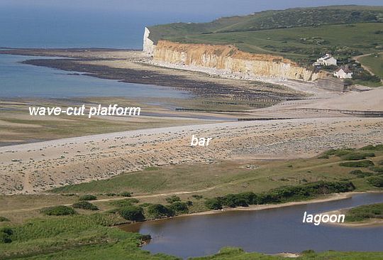
• Cuckmere Haven with bar (=Nehrung(D)), lagoon (=lagune) and wave-cut platform (=brandingsplatform).
• bar= where a spit grows across a bay or estuary and joint up with the beach on the other side.
• The cottages were built to give early warning of a Napoleonic invasion.
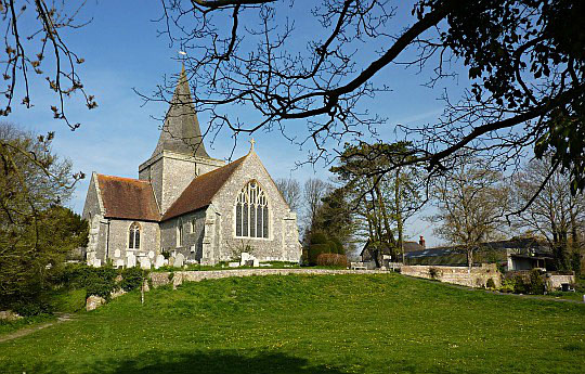
• Alfriston Church.
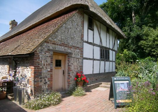
• Old Clergy House (= pastorie; 14de-eeuws) , Alfriston. It is partly flint-built.
• Omdat de kalksteen uit de South Downs poreus is, gebruikt men hier flint (vuursteen) als bouwmateriaal.
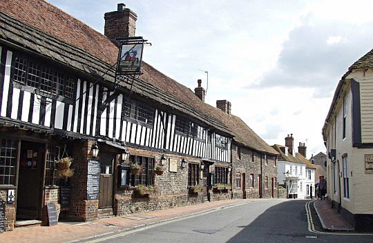
• The George Inn and High Street, Alfriston.
• Er zijn mooie vakwerkgebouwen in dit prachtige dorp.
Beste periode:
Half juni ― half september is beste periode.
Je bent hier aan de kust. Dat betekent dat het op bewolkte dagen met wind al snel koud aanvoelt.
In september is het al wel vroeg donker.
Er valt hier weinig neerslag.
( Voor het weerbericht ga je naar www.metoffice.gov.uk/ )
.Climate - Stat. Herstmonceux W. E. |
apr |
mei |
jun |
jul |
aug |
sep |
okt |
.Gemiddelde maximumtemp. °C |
13
|
17
|
19
|
21
|
22
|
19
|
15
|
.Maandsom neerslag (mm) |
52
|
51
|
54
|
54
|
61
|
65
|
108
|
| ( Gem. maximumtemp. De Bilt ) | 14
|
18
|
20
|
23
|
23
|
19
|
15
|
Zwaarte:
![]() Middelzware dagwandelingen.
Middelzware dagwandelingen.
De voorlopers van de riviertjes Cuckmere, Ouse en Adur hebben, diepe dalen
ingesneden in de krijtrug ( zgn. doorbraakdalen).
Voor de South Downs Way betekent dat drie keer 100 m
dalen en stijgen.
![]() Het pad blijft door de krijtbodem na regen goed droog, dus ook goed begaanbaar.
Het pad blijft door de krijtbodem na regen goed droog, dus ook goed begaanbaar.
![]() Omdat de South Downs Way een "bridleway" is (dus voor "foot, bike and horse"),
heeft
men "bridle gates".
Deze zijn gemakkelijk te openen.
Er zijn dus géén lastige "stiles to clamber over".
Omdat de South Downs Way een "bridleway" is (dus voor "foot, bike and horse"),
heeft
men "bridle gates".
Deze zijn gemakkelijk te openen.
Er zijn dus géén lastige "stiles to clamber over".
Routemarkering:
Zeer goed, zoals alle "national trails".
Bevoorrading:
• Levensmiddelen: onderweg kom je met voldoende regelmaat bij een winkel.
• Drinkwater: is wel een probleem. Er zijn slechts enkele "water points" (drinkwaterpunten) op de
deelkaartjes ingetekend.
Vul daarom telkens bij het
verlaten
van een dorpje
de
veldflessen.
There are only a limited number of places where drinking water can be obtained
along the South Downs Way. This is because the trail runs mostly along the crest
of the Downs, while all of the villages and springsare at the foot of the Downs.
Please ensure that you carry enough water.
ANWB Campings:
Zie voor een overzicht anwb.nl/engeland
Wildkamperen (bivak):
Gaf mij geen problemen.
![]()
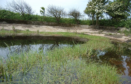
• Dew pond (=drinkpoel ; letterlijk: dauwvijver) langs de South Downs Way.
Hoogtepunt:
• Eastbourne — Alfriston ... 18 km .. (a cliff-top rollercoaster)
This
is a classic white-cliffs walk with Beachy Head and the Seven Sisters
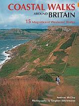
Goede informatie over dit deel van de kust vind je in het prachtige boek: Coastal walks around Britai..., Andrew McCloy.
Daarin bespreekt hij het traject Eastborne ― Seaford als één van die 15.
(Lengte: 22,5 km (14 miles); Tijdsduur: 7 hours/ 1-2 days).
(Bij Seaford Head bevindt zich het klassieke uitzichtpunt van mijn grote
foto
vooraan.)
In Duitsland op het Oostzee-eiland Rügen heeft men ook een zeer
bekende cliff top walk, namelijk de 'Hochuferweg' in het
Nationalpark Jasmund. Deze behoort zelfs
tot de Top 10 van mooiste dagwandelingen van
Duitsland
en vind ik mooier dan bovenstaande
Eastbourne—Alfriston.
Zie voor een goede introductie van de verschillende kustvormen:
engeland_coastal-...
Coastal landslides at Beachy Head:
Zie hiervoor:
www.bgs.ac.uk/landslid...
Routeverbeteringen:
Wandelend boven over de cuesta is er aan vergezichten geen
gebrek.
(Het is dus een Panoramapad !)
Maar km's lang wandelen over kort
grasland zonder
struikgewas of bomen gaat
snel vervelen. Daarom kun je beter
zo nu en dan het
pad verlaten en
korte
tijd
parallel daaraan door de prachtige
dorpjes aan de voet
van de escarpment (= cuestafront) lopen.
Twee voorbeelden:
• Voorbij de parkeerplaats bij Bostal Bottom wandel je naar beneden naar Charleston Farm en Firle. Klim ten westen van Firle weer ergens de rug op.
Dit is slechts 100 hoogtemeters stijgen, dus goed te doen.
• Voorbij Lewes wandel je op dezelfde manier naar het gehuchtje Westmeston.
Je zult zien dat de escarpment (het cuestafront) op sommige plaatsen
mooie doornstruwelen,
holle wegen en heggen heeft.
Ook de dorpjes zijn schitterend.
Eindbeoordeling:
Met de voorgestelde routeverbeteringen erbij, zijn deze 4 dagen in
het oostelijke
deel van de
South Downs Way een heel aardig
langeafstandspad.
Top trail-kwaliteit heeft daarvan alleen de kustlijn-etappe
(Alfriston-Eastbourne).
Beste websites:
www.sherpavan.com/tra...
Sites komen en gaan; dat valt niet bij te houden.
Googel daarom ook een keer naar south downs way en bekijk de eerste
10 (evt.
20)
resultaten. Daar zitten de belangrijkste sites wel tussen.
![]()
• View north-west from Firle Beacon.
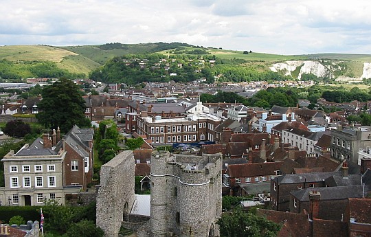
• Lewes: Looking at the town from the top of Lewes Castle.
| aaaa |
Krijt =
1. de naam van een periode uit de
geologie,
2. de naam van een zachte kalksteen
De Krijtperiode duurde van ca. 142 tot 65 miljoen jaar geleden en eindigde met de inslag van een grote meteoriet in Yucatan (Mexico). Daarmee kwam, zoals bekend, een einde aan het leven van de Dinosauriërs, de Ammonieten en vele andere planten- en diersoorten.
Krijt is ook de naam van een zachte kalksteen (CaCO3 - Calcium carbonaat) die bijzonder zuiver is en daardoor wit.
Het bestaat grotendeels uit de skeletjes van eencellige algen.
Chalk (=krijt) = a soft limestone formed mainly of coccolith skeletons.
We zien deze krijtrotsen niet alleen bij
de White Cliffs of Dover en
Cap Blanc Nez, maar
ook op Rügen en het Deense Møn.
Lopend langs krijtkliffen, zie je dat deze ‘doorregen’ zijn met donkere,
tot
10 cm dikke banden. Dat is vuursteen. Deze vuursteen is afkomstig
van
de kiezelskeletten van sponzen en eencellige algen (diatomeeën).
De kiezel – SiO2, siliciumdioxide - van de skeletjes loste op en migreerde,
nog voor het gesteente hard werd, naar de – oorspronkelijk horizontale - laagvlakken in de krijtlagen waar het neersloeg. ....
| aaaa |
Limestone areas in England and Wales:
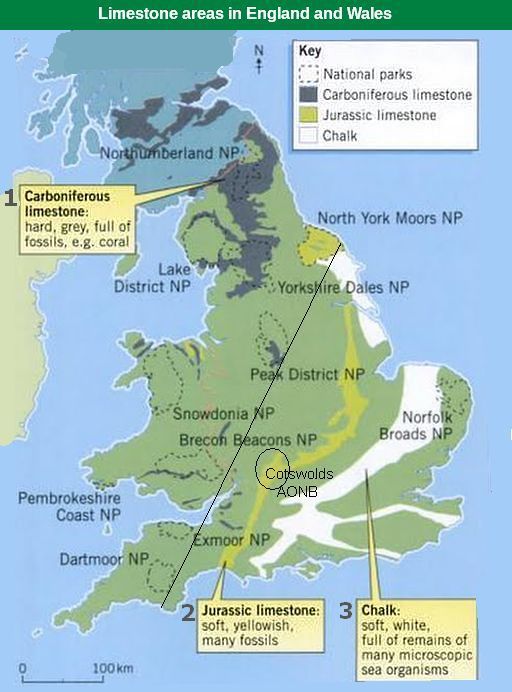
• There are three types of limestone in the British Isles, but the one that
forms
the highest upland areas is Carboniferous limestone (1) (kalksteen uit
het Carboon).
• Links van de diagonale lijn liggen de uplands (=gebieden hoger dan ongeveer 1,000 feet (± 300m) boven
zeeniveau.) De belangrijkste upland limestone landscapes in Engeland zijn: Northumberland NP , Lake District NP , Yorkshire Dales NP , North York Moors NP en Peak District NP.
• Je ziet op de kaart dat North York Moors NP wel uplands is (het ligt links van de diagonale lijn), maar geen Carboniferous limestone (1) heeft, In plaats daarvan
heeft ze de zachte, geelachtige Jurassic limestone (2).
Deze Jurassic limestone vormt een 500 km lang massief tussen Lyme Regis aan de zuidkust en Whitby aan de noordoostkust.
Ook de Cotswolds hebben die zachte, geelachtige kalksteen, maar omdat ze ten oosten van de diagonale lijn ligt, is het dus géén upland.
The map shows the three sedimentary rocks that are made from sea
creatures:
1. Carboniferous limestone
(kalksteen uit het Carboon: hard, grijs),
2. Jurassic limestone
(kalksteen uit de Jura: zacht, geelachtig) and
3. Cretaceous chalk
(krijt uit het Krijt: zacht, wit) ,
Jurassic limestone (2) and Cretaceous chalk (3) can hold water – they have tiny holes in them
and are very porous.
Carboniferous limestone (1)
Carboniferous limestone is not at all porous — although it is permeable (=doorlaatbaar) Water seeps through the joints.
The limestone is laid down in layers or 'beds' separated by bedding
planes (laagvlakken) and divided up into blocks by a series of joints (vertikale scheuren) (Joint = een vertikale scheur in een gesteente zonder dat het gesteente aan beide zijden verschoven is.)
These Joints in rock are caused by shrinkage or release of pressure as rocks above are eroded away. (Zie verder upland limestone landscapes)
A long time ago, about 350 million years ago (even before the
Dinosaurs) England was covered by a
shallow tropical sea – a bit like
where the Great Barrier Reef is forming today.
As the small animals and corals that lived in the sea died, their shells and skeletons fell to the bottom. A thick layer built up over millions of
years.
As it squashed and hardened, it eventually turned into limestone.
This Carboniferous limestone (1) is nowadays found in:
- northern
England (e.g. Yorkshire Dales, Peak district),
- Wales (e.g. Brecon Beacons) and in
- Ireland (e.g. The Burren).
| aaaa |
The Weald Uplift:
• Het gebied dat nu The Weald genoemd wordt, bestaat uit sedimentaire lagen die
zijn opgeheven tot een koepel. (Let op ! Dit blokdiagram overdrijft de hellingshoek. Ze is slechts enkele graden).
• Later zijn door erosie de krijtlagen in het centrum verdwenen en oudere lagen
blootgelegd. Alleen de randen van The Weald bestaan nog uit krijtheuvels. Dit zijn
de South Downs en de North Downs. Ga je dus vanuit de South Downs naar het centrum van The Weald, dan kruis je steeds oudere afzettingen. Door de afwisseling van hardere en zachtere lagen in deze afzettingen is daar een patroon van ruggen en dalen ontstaan.
• As the central part of the dome is eroded away, older rock layers are exposed.
As each layer is cut through, it is eroded back from the center.
Thus the chalk cuestas
have their escarpment (scarp slope) (=cuestafront) facing toward the center of the
dome and retreat away fromt the center. They enclose a concentric series of exposed clay vales and sandstone ridges.
• Wie met de auto van Dover naar London rijdt, ziet de escarpment (scarp slope) (= het cuestafront)
van de. North Downs aan de noordzijde van de motorway.
The Cuesta of the South Downs:
• Cuesta's kunnen ontstaan, als er in een gebied een hardere laag
ligt, met erboven en eronder een pakket zachtere lagen,
waarbij het geheel flauw (enkele graden) helt.
• Erosie neemt de bovenliggende zachtere lagen weg, waardoor de flauw hellende hardere laag wordt ontbloot en hierop een lange, flauwe helling, een z.g. dip slope ontstaat.
(dip is de hellingshoek in graden met het horizontale vlak)
• Verwering en denudatie kunnen ook plaatselijk de harde laag doorbreken, waardoor de onderliggende zachtere lagen kunnen eroderen, waarbij het materiaal wordt
afgevoerd door een beek of rivier. Vervolgens breken stukken van de hardere laag af en ontstaat er een zeer steile helling, soms is ze zelfs klifachtig.
Deze zeer steile helling is de escarpment ; scarp slope (=het cuestafront) (Gewoonlijk vertalen we escarpment in het Nederlands door steilrand, maar hier bij cuesta's heeft men in de geologie daar een eigen woord voor: het cuestafront.)
• Het geheel vormt een asymmetrische rug, een cuesta.
Vanaf de hoogste kam loopt één helling flauw af, de andere helling is zeer steil, soms zelfs een klif.
• Vaak bestaat het systeem uit een meerdere min of meer evenwijdige cuestafronten.
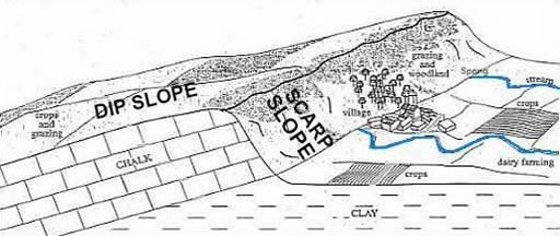
• Dit blokdiagram overdrijft de hellingshoek van de dip slope. Ze is slechts enkele graden.
Formation:
1. To form an cuesta you need two rock types of different hardness.
In Southern England the South Downs has chalk (relative hard) alternating with clay (relative soft).
2. These rocks were tilted (=gekanteld) by earth movements. As a result these beds of rock now dip (hellen) at an angle.
(dip ww. = hellen ; dip zelfst.nmw. = helling ; de hellingshoek in graden met het horizontale vlak)
3. The more resistant chalk (=krijt) erodes less quickly than the softer clay.
As a result the chalk forms the higher cuesta and the clay the lower vale (valley).
4. As chalk is permeable (=doorlatend) water soaks through it until it
meets the impermeable (=ondoorlatend) clay. At this point a spring (=bron) is formed. (Als het inzijgende grondwater op een ondoorlatende laag
stuit, stroomt het zijwaarts af en treedt dan uit als een bron.)
Land use:
1. Early human settlers located their villages at the base of the escarpment (scarp slope) (=cuestafront) as this is where the permeable chalk meets the impermeable clay forming a spring for the villages water supply.
2. The clay vale has rich deep soils that provide excellent soil for dairy farming. Crops can also be easily grown
on the flat land.
3. The thinner soils on the dip slope produce short grass used for sheep farming.
4. Chalk can be quarried and forms an attractive building stone ; it is also used to make cement.
5. The escarpment (scarp slope) (=cuestafront) provides excellent shelter from wind.
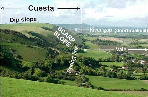
• Je kijkt hier westwaarts vanaf het uitzichtpunt ten westen van Devil's dyke.
• Linksboven is de Dip slope (lange, flauwe helling). Ze is op het zuiden gericht.
• In het midden:
de op het noorden gerichte zeer steile helling: the escarpment (scarp slope) (=cuestafront (Ned.) Daar groeien enige
struikjes, maar verder
is ze
kaalgevreten door de schapen.
• Bovenop de poreuze krijtrug zakt regenwater gemakkelijk naar beneden. Op plekken waar het op een ondoordringbare kleilaag stuit, stroomt het
daarna zijwaarts naar het dal. Daar treedt het uit als een natuurlijke bron. In de foto zie je de bronnenlijn (spring-line) aan de voet van het cuestafront.
• De nederzetting rechtsonder is een spring-line settlement.
• Het hoogteverschil tussen de kam van de cuesta en de voet is hier ± 100 m. ....
| aaaa |
Belangrijke cuesta's in Engeland:
..
The map shows two long curving almost parallel cuesta's.
• The western limestone/sandstone cuesta consists of:
Cotswold Hills + Lincoln Edge + North York Moors.
(The southern end of this winding cuesta forms the
peninsula of Purbeck Hills on the English Channel. The more massive limestones and sandstones give rise to 300-metre escarpments (=cuestafronten), yet the dip slope is frequently of such a low angle that
the countryside resembles a dissected plateau ( plateau doorsneden
door
rivierdalen), passing gradually on to the clay vales.
• The eastern chalk cuesta consists of:
Chiltern Hills + Lincolnshire Wolds + Yorkshire Wolds.
(The southern end of this winding cuesta is on the Isle of Whight.)
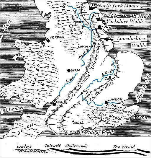
The cross section below the map shows the two relative hard layers
which form these two cuesta's.
These hard layers are separated from each other and also from the
underlying complex basement of older rocks by softer formations
of clays.
These clay beds underlie the two lowlands which form long belts just
west of the two cuesta's.
- Draining the western lowland are the rivers North Ouse, Trent and Avon.
- The eastern lowland is drained by the Southern Ouse, and the Upper Thames. (This eastern lowland is known as the “Educational Lowland”, because it contains the cities of Oxford and Cambridge and other famous schools.)
The hard layers forming the cuesta's are limestone and sandstone beds.
The upper limestone bed which forms the Chiltern Hills is a chalk (krijt) formation , which comes out again in the South Downs and North Downs.
It also forms the “White Cliffs of Dover” ....
| aaaa |
Van dag tot dag (www.sherpavan.co...)
1. Eastbourne ― Alfriston (19 km)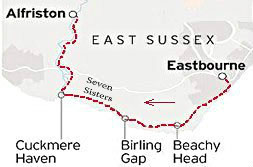
from Eastbourne Station.
(Deze dagetappe behoort tot
de
beste dagwandelingen van Groot-Brittannië.)
- This is one of the most gorgeous sunny-day clifftop walks it is possible to imagine.
-
Best of all is when you quit Eastbourne's hot streets, rising from grey concrete along the grassy South Downs Way.
- Go past the gloomy brilliance of Beachy Head (163 m) (Head = kaap) clifftopping westwards with the brief interruption of a car park and another oasis-like pub at Birling Gap.
- Then the best bit: along the green tops of the Seven Sisters Cliffs, a series of chalk-white, up-down cliffs, that sum up southern Britain far better than Dover.
- It's a taxing rollercoaster walk that dips and soars. (De golvende krijtheuvels zijn kaarsrecht afgesneden door de zee.)
-
But the sea views are exhilarating to your left. The green wooded landscape lush to your right as you picnic.
-
Then plunge to the Cuckmere River Valley (een doorbraakdal).
-
Here you strike north at last, following a trail away from the sea over the coast road through dark Friston Forest and finally to the pleasant village of Alfriston.
- This is one of the most beautiful villages in the Downs.
-
The large church in the village is often called " the Cathedral of the Downs".
Belangrijk:
a. Visitors must always stay a safe distance away from the cliff edge(klifrand; rand van de afgrond) which is very unstable.
b. You are strongly advised not to walk the beach between Cow Gap and Birling Gap. Tide changes and regular cliff falls make this walk
both difficult and dangerous.
2. Alfriston ― Rodmell (15 km)
- The Way rises up onto the high Downs reaching a high point on this
section at Firle Beacon.
-
Walk across farmland, until you reach the River Ouse gap near Rodmell.
-
Fans of the Bloomsbury group of Bohemian artists will be keen to make an off route diversion to Alciston, Berwick and West Firle with various pubs and teashops.
-
Rodmell village has a pub and the “Monk’s House, where Virginia Woolf used to live.
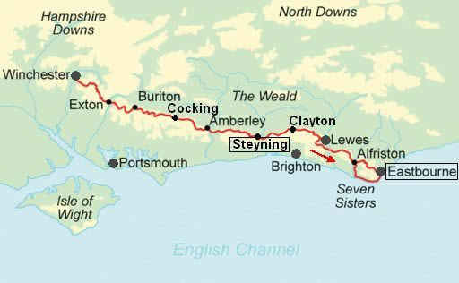
3. Rodmell ― Clayton (22½ km)
- After the Ouse the trail climbs above the historic town of Lewes.
-
This section takes you up onto the highest parts of the Downs, round the back of the Brighton ('Londen aan Zee') and Worthing conurbation,
following mainly grassy tracks.
-
You go over the highest point on the route at Ditchling Beacon 248 m.
-
You may find an ice cream van up here in summer.
-
Eventually, passing lark filled skies, the white “Jack and Jill” Clayton windmills greet you on your descent down to Clayton;
4. Clayton ―Steyning (16 km)
- The route ascends and descends via the “Devil’s Dyke” – said to be the . World’s largest chalk dry valley. (It was formed in periglacial times, when the ground froze, so meltwater rivers ran over the surface of the chalk rather than flowing down through it. These rivers carved out V-shaped valleys.
Once the climate had warmed again the river abandoned the valley and a dry valley was left behind. )
-
There is a pub restaurant here, great views and circular walks that you can do if you want to spend more time on the heights.
-
We then walk on through the parish of Upper Beeding to drop down to the Ardur Valley (een doorbraakdal).
-
There follows another lovely stretch of The Downs with great views down to the villages below and ancient historical features abound such as Tumuli burial mounds and cross dykes.
-
We descend off the Down to Steyning, a busy small country town with some nice shops;
Belangrijk ! :
Loop deze route liever in omgekeerde richting. Begin dus
in Steyning en kom vier dagen later aan in Eastbourne. Het meest bijzondere gedeelte komt dan de laatste dagen.
• Bovenstaande dagetappes kunnen als leidraad dienen voor degenen
die
B & B boeken en dus met slechts een lichte dagrugzak lopen.
• De wandelaars met trekkingrugzak en tent hebben zo'n indeling niet
nodig.
Zij zijn vrij als een vogel en kunnen 's avonds overal wel een
tentplek vinden.
Ze doen er overigens wel goed aan 1 à 2 dagen extra
te
rekenen, omdat je met een trekkingrugzak minder km's per dag
aflegt
dan met een dagrugzak. ....
| aaaa |
SNP Natuurreizen heeft in Groot-Brittanië ook wandelreizen:
Hun reizen met een zwaarte van 1 of 2 zwarte cirkeltjes komen het beste overeen met mijn wandelingen.
Je maakt dan niet te veel hoogtemeters en wandeluren per dag.
Zie: www.snp.nl/reizen/
| aaaa |
Wandelgids: The South Downs Way, Strookkaart:
Harvey Maps 1 : 40,000
Harvey strip maps (strookkaarten) zijn de beste
kaarten. Boeken met informatie over deze tocht:
Coastal Walks Around Britain, Wandelvakanties dicht bij huis; Te bestellen bij: Reisboekwinkel de Zwerver (webshop voor reisgidsen en landkaarten) |
..Deze wandelsite is niet-commercieel, onafhankelijk en gratis. Dat is enkel mogelijk door steun van de bezoekers. Uiteraard kun je ook doneren door overschrijving op mijn ING-bankrekening: |
.... Reactie van Emil en Monique Bregita: Beste Piet, Heel prettig om als wandelaar door jouw site heen te snuffelen zeg !! Omdat jij ook een deel van de SDW gelopen hebt, vroegen wij ons af
hoe het
daar zit met wildkamperen. Weet je daar iets vanaf?? Hopelijk kun jij ons vertellen dat we zo her en der onze tent wel kunnen neerzetten zonder opgepakt te worden. Met vriendelijke groet, Emil en Monique Bregita Beesd. Beste Emil en Monique, Ik kampeer altijd en bijna overal wild. Zet tegen de avond om 20.00
uur
je
groene tentje op een onopvallende plaats en niet bij bebouwing.
Je hoeft dan geen problemen te verwachten. Groet, |
Weet je aanvullingen en verbeteringen van deze tekst?
Graag een e-mail naar:
![]()
![]() ....
.... ![]() ....
....![]()
LAATST BIJGEWERKT : 7-1-2019