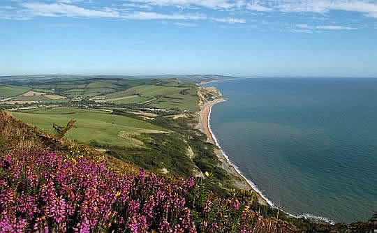
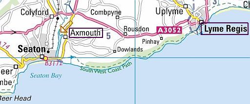
. SOUTH .. WEST . COAST . PATH
.................DORSET
... Seaton – Poole Harbour = 125 ½ km
The Dorset Coast (Jurassic Coast) has excellent examples of coastal
features:
Dorset is a small county on the south coast of England and contains some
of the
most striking examples of coastal features (kustvormen) in the British
Isles.
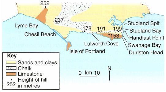
1. Coastal erosion (kusterosie):
As
the map below shows, several rock types reach the sea along the
Dorset
coast,
some of them resistant, others more soft.
• The resistant rocks, such as
chalk (krijt) and limestone (kalksteen),
form cliffs and headlands
that display
caves (brandingsgrotten),
arches (brandingsbogen), and
stacks (brandingspilaren).
Handfast Point is a good example of a headland and it has stacks
such
as
Old Harry
and Old Harry's Wife (see map below).
• The soft rocks, such as clay and shale (kleischalie), have been quickly eroded to
form beaches at the back of bays,
such as Lulworth Cove and Swanage Bay.
2. Longshore drift (kustdrift):
The dominant winds and waves come from the south-west so the waves
wash
up
the beach at an angle and longshore drift (kustdrift) takes place.
3. Deposition (kustsedimentatie):
The longshore drift has formed sandspits (zand-schoorwallen, zandhaken),
such
as
Studland Spit, and the
Isle of Portland has been
joined to the mainland by a tombolo (tombolo) called
Chesil Beach. It is 30 km long and up
to
15 metres
high
and is believed to have
once been an
offshore sandbar
(zandwal).
Elsewhere, beaches are commonly found at the back of bays, such as
Swanage
Bay.
Zie voor een goede introductie van de verschillende kustvormen:
engeland_coastal-landscapes
| tGEOLOGY OF THE DORSET COAST (Jurassic Coast) |
| . SOUTH WEST COAST PATH .(Jurassic Coast): SEATON – POOLE |
Korte samenvatting wandeltrektocht Jurassic Coast:
Ik wandelde naast de route door Dorset ook
Axmouth to Lyme Regis...
Deze laatste ligt gedeeltelijk in het graafschap Devon.
• We start in Seaton (East Devon) and follow the coastal path as it extends eastwards towards Lyme
Regis (Dorset) .
This section includes The Undercliffs, now a
nature reserve.
• Lyme Regis is the’ Pearl of Dorset’ whose charm has persuaded many famous
writers to stay, among them
Jane
Austen, Thomas Hardy and John Fowle’s
whose
novel “The French Lieutenant’s Woman” is set here.
• Reaching Charmouth the cliffs are famous for their dense fossil deposits.
A complete Plesiosaur (think of the Loch Ness Monster) was discovered here
and you might well find your own 100 million year old fossil if you look carefully.
(If unsuccessful visit Charmouth’s Old Forge fossil shop).
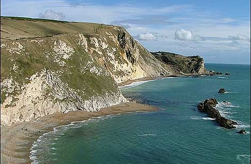
• From the headland, you are rewarded by the spectacular orange sandstone cliffs
of Golden Cap cliff (191 m) – the highest point on the south coast with a
panorama
of
amazing
far reaching views in all directions.
• Descend to West Bay and walk straight into Broadchurch ! Here is the striking
location of television’s drama series ‘Broadchurch’ , attracting a record 9 million
(armchair) viewers to the wonderful backdrop and enchanting small harbour
town, Bridport.
• Further along you come to 28 km long Chesil Beach, one of the finest barrier
beaches in Europe protecting an important nature reserve The Fleet.
The unique
bank of colourful pebbles grow from pea size at Burton-Bradstock
to potatoe
size at Portland.
• You stay in the beautifully preserved village of Abbotsbury, which has no street
lighting and a medieval tithe barn still in use as a storehouse.
Abbotsbury has the oldest managed swan population in the world. For over 600
years a colony of mute swans (= knobbelzwanen) has been living at
Abbotsbury
Swannery set up by
medieval monks as a food source.
• The final part of the walk rises and dips along the cliffs above the natural arch
of Durdle Door, and down to Lulworth Cove – a perfect horseshoe bay ringed
with
magnificent cliffs.
• If the Lulworth ranges are open the walk follows the cliff, otherwise there is a
detour.
• At Kimmeridge Bay the nodding donkey (jaknikker) pumps oil from the
shale.
• Finally along the chalk cliff tops to famous Old Harry Rocks stacks
(=brandingspilaren, klippen)
standing like
guardians of this unique stretch
of beautiful
coastline.
• Lyme Regis with The Cobb (= havenmuur) to the left. The Cobb was the backdrop to the climax of the film The French Lieutenant's Woman.
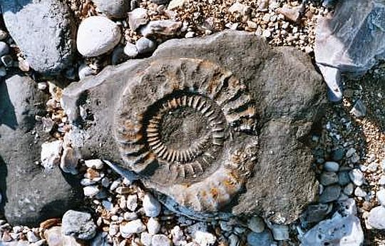
• Charmouth has the most famous fossil site along the coast.
• View from Golden Cap to the east.
• Golden Cap is the highest point on the whole south coast (191 m).
Video YouTube:
BBC Coast 1 ..01 of 12...Dover to Exmouth. vanaf 41:43 tot einde
Fotoalbum:
www.ramblingpete.w... (tweede helft route)
Begin- en eindpunt:
Van Seaton naar Poole.
Lengte en tijdsduur: 125½ km
• Als je deze wandeltrektocht met een lichte dagrugzak loopt, terwijl je de
hoofdbagage laat bezorgen,
kun je het traject in 7 dagen doen(zie verderop bij Van dag tot dag).
• Ga je echter met trekkingrugzak en tent dan heb je zo'n indeling niet nodig.
Je bent dan vrij in doen en laten en kunt 's avonds altijd wel een tentplek
vinden.
Je hebt dan wel 1 tot 2 dagen méér nodig, omdat je met een trekkingrugzak
minder kilometers per dag aflegt.
Beste periode:
Half juni ― half september is beste periode.
Je bent hier aan de kust. Dan is het op bewolkte dagen met wind
zelfs
nog
in
begin
juni
koud.
September is al wel vroeg donker.
De neerslag is seizoensgebonden. In de winter valt er veel, maar
de zomer
is
droog.
(Voor het weerbericht ga je naar www.metoffice.gov.uk/)
.Climate – Stat. Weym., Wyke Regis |
apr |
mei |
jun |
jul |
aug |
sep |
okt |
.Gemiddelde maximumtemp. °C |
12
|
15
|
18
|
20
|
20
|
18
|
15
|
.Maandsom neerslag (mm) |
49
|
45
|
40
|
40
|
50
|
56
|
85
|
| ( Gem. maximumtemp. De Bilt ) | 14
|
18
|
20
|
23
|
23
|
19
|
15
|
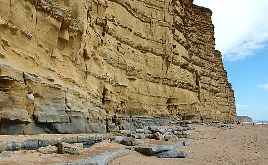
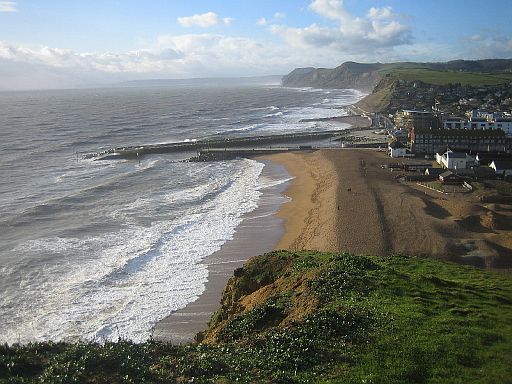
• East Cliff at West Bay (view looking east towards Burton).
• The cliffs are made up of alternating layers of hard and soft sandstone beds (=lagen) .
• The small hollows are home to numerous birds.
• Erosion at the foot of the cliff has exposed many fallen rocks, and enlarged the joints, some. into caves.
• Sandstone is a sedimentary rock (sedimentgesteente). It is made up of small particles of sand, which have been transported by the wind, rivers and ice and are usually deposited on lake or seabed. Over many millions of years, successive layers of sediments accumulate.
These layers of sediments are compressed by the weight of the deposits above, into sedimentary rocks. These rocks form in layers, known as bedding planes (=laagvlakken).
... Bed (Laag) ... Bedding plane (Laagvlak) |
Zwaarte:
De meeste dagwandelingen zijn middelzwaar.
Alleen
de 6 e dag door de Lulworth Ranges is zwaar.
Zie verderop bij Van dag tot dag voor meer details.
De kleiige padgedeelten zijn bij neerslag glad. Loop in dat geval liever over
het
gras
erlangs.
There are some steep sections of coastal path,
however
the steep hills are a
maximum of 200 metres of ascent/ descent in one
go
and are often much
less.
Routemarkering:
Zeer goed, zoals alle "national trails".
Openbaar vervoer: goed.
Je kunt desgewenst met openbaar vervoer naar
het beginpunt/eindpunt
van de dagwandeling
reizen.
Bevoorrading: goed.
• Levensmiddelen: iedere dag is er wel een plaats met een supermarktje.
• Drinkwater: denk eraan dat veel openbare toiletten geen goede
drinkwaterkraan hebben om een fles te vullen.
• Rock falls in chalk (krijt) slopes at Mupe Bay.
• The white cliff is made of billions and billions of shells of microscopic plankton, which have. slowly compacted into huge beds of chalk.
• Krijt is een fijnkorrelige, witte kalksteensoort, die uit de skeletten van
microscopischplankton bestaat.
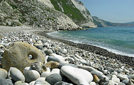
• Through the "eye" of a stone at Mupe Bay.
• Iets verderop zie je het resultaat van de serie rock falls opnieuw, maar nu beneden vanaf het strand.
Hoogtepunten:
• Axmouth to Lyme Regi... an active coastal landslide system.
• Black Ven landslide complex between Lyme Regis and Charmouth.
• Fossil sites at Charmouth.
•
Golden Cap cliff (191 m), the highest point of the south coast of England.
• Chesil Beach the great shingle bar ( kiezelwal ), backed by The Fleet the
semi-freshwater lagoon.
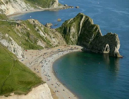
•
Durdle Door the textbook arch and Lulworth Cove the hollowed-out cove.
• Old Harry Rocks , the chalk (= krijt) stacks (= brandingspilaren, klippen) at
Handfast Point (one of the most famous landmarks on the Jurassic Coast)
(landmark =markante object)
• Coastal flowers and birds.
• Occasional seals, dolphins and basking sharks (Reuzenhaaien).
Hoogtepunt volgens www.ldwa.org.uk:
• West-Lulworth ― Kimmeridge ....11 km.
Ik vond vooral de 2 de helft hiervan erg mooi !
Bekijk de exacte data dat de Lulworth Ranges open zijn:
www.southwestcoastp... (Accessible most weekends and school holidays).
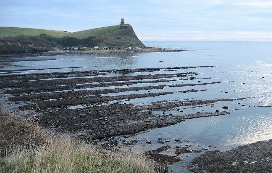
• Kimmeridge Bay: aan de voet van de kliffen is door de branding een brandingsplatform ontstaan (Eng: wave-cut platform) Bij laagwater valt het gedeeltelijk droog.
• Je kijkt oostwaarts. In de verte zie je Clavell Tower.
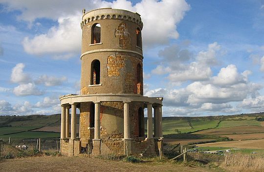
• Clavell Tower , Kimmeridge Bay;
• A folly built by Rev. John Clavell in 1831 and used as a coastguard lookout.
• Built of yellowish dolomite from the beach with some brick and with a Portland Stone colonnade.
• Men heeft de toren steen voor steen afgebroken en een aantal meter landinwaarts herbouwd. Anders zou hij nu al met een van de klifafstortingen in zee zijn gedonderd.
• Je kijkt westwaarts. Links zie je Clavell Tower.
ANWB Campings:
Zie voor een overzicht anwb.nl/engeland
Wildkamperen:
Een nachtje bivakkeren ('s avonds de trekkerstent opzetten en 's morgens
weer
afbreken) gaf geen problemen.
Extra dag mogelijk:
• Abbotsbury.
Jurassic Coast :
• It became England’s first natural World Heritage Site.
http://news.bbc.co....
• The site stretches from Orcombe Point near
Exmouth in
East Devon to Old Harry Rocks
near Swanage in East Dorset, a distance of 155 kilometres.
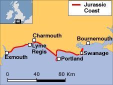
• What makes this coast so special is the way its cliff exposures provide an almost
continuous geological 'walk through time' spanning the Triassic, Jurassic and
Cretaceous periods.
It's like a time capsule holding 185 million years of the Earth's
history.
Zie ook http://nl.wikipedia.org/...
Jurassic Coast Bus X53:
The Jurassic Coast Bus Service is ideal for walkers who want to walk along
a section
of the coast path as they have the option of either travelling out
or back
by bus.
The service connects Seaton, Lyme Regis, Charmouth,
West Bay,
Burton Bradstock,
Abbotsbury, Weymouth, Osmington Mills, Lulworth Cove,
Swanage,
Studland and
South Haven Point (Poole Harbour)
(Summer service).
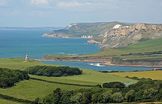
 • A massive landslip marks Houns-tout Cliff, here seen with other promontories along the coast. Je kijkt vanaf Emmetts Hill naar het westen.
• The Slumped (afgeschoven), dark slopes below Houns-tout Cliff are made up of unstable shales (kleischalies),
which,
because
they are topped with porous limestone, become saturated and periodically slide
away
causing
major rockfalls.
Coastal Path Diversion:
Zware regenval en de onstabiele geologische structuur doen bij de kliffen
voortdurend
gesteente afbrekenen en omlaagstorten (rock falls).
Van tijd tot tijd zijn er ook grote aardverschuivingen (landslips).
Dit betekent dat het kustpad omgeleid moet worden.
Zie voor al deze omleidingen www.southwestcoastpath.o...
Beware of unstable cliffs / falling rocks:
Ik ken geen ander kustpad met zoveel rock falls en landslips.
Wees dus zéér voorzichtig.
Het kustpad loopt gedeeltelijk bovenlangs de klif. Op een aantal plaatsen nadert de terugwijkende klifrand tot op een
meter
het pad.
Dit kan gevaarlijk zijn,
indien het klif op die plaats ondermijnd
is.
Het overhangende gesteente zou dan kunnen afbreken en omlaagstorten.
Daarom geldt als regel:
• blijf bovenop de klif op ruime afstand van de klifrand en
• beneden op het strand ook ver genoeg van de voet van de klif.
www.bbc.com/news/u...
......................................
www.bbc.com/news/u...
Eindbeoordeling:
Dit deeltraject is een zeer mooie top trail.
Zelfs mooier dan SWCP: West-Cornwall en Pembrokeshire Coast Path.
Beste websites:
www.southwestcoast...
......................................
www.oppad.nl/?bestem...
........................................
http://jurassiccoast.org/
......................................
www.luggagetransfers...
Introductie South West Coast Path
Zie hiervoor op mijn website:South West Coast Path
Zie voor een goede introductie van de verschillende kustvormen:
engeland_coastal-lands...
... Let op het verschil tussen:
|
| aaaa |
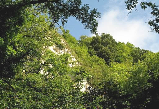
The Undercliff:
(Oerwoud-achtig gebied ! )
An undercliff is a sloaping section of coast between the top of the cliff
and
the beach.
It is
torn into ridges and throughs,
which are shaped by small landslips.
• Tussen Axmouth en Lyme Regis zijn grote stukken klif afgeschoven.
• De oorzaak is een ondoorlatende, gladde kleilaag onder de poreuze kalk- en zandsteenlagen.
• Regenwater dringt in de kalk- en zandsteenlagen, en maakt ze zo zwaar dat
ze naar beneden schuiven over de kleilaag.
• Let op ! Als men met bordjes aangeeft dat het pad op een plaats geblokkeerd is door een aardverschuiving, dan kun je er toch gaan wandelen.
Ga dan vanuit Axmouth of Lyme Regis over het pad tot aan die aardverschuiving en keer vervolgens om en over hetzelfde pad weer
terug.
• The Undercliff stretches almost 7 miles in length between Axmouth and
Lyme Regis and can
be
accessed via the South West Coast Path which runs through the entire length of the reserve.
Onderstaande mooie beschrijving vond ik op:
http://jsbookreader.blogs
• Created by past and ongoing landslips, the Undercliff is essentially a south-facing forested ledge (=terras) around seven miles long and at most a quarter of a mile wide, bounded
on one side by cliffs down to the sea and
on the other
by a ravine and further cliffs to landward.
• The underlying terrain, rumpled by the landslides is chaotic, a mess of ridges and deep gullies.
• The vegetation at the western end is generally bushes and scrub, including bracken, brambles and smaller trees like hawthorn.
Further east the Undercliff becomes a proper wood with large mature trees (ash, maple and beech).
• It has been described as the nearest thing Britain has to a jungle(oerwoud-achtig!), and this was an especially accurate description
when walking it on
a close, hot summer afternoon.
We got through a litre of water each, and could easily have done with more.
• There are some clear vistas back to crumbling chalk (=krijt) cliffs, but only occasional glimpses out to the coastline.
• The path
switches rapidly between easy forest path and, mostly, an exhausting succession of ups and downs via slopes with slippery flints (=vuurstenen) and small flights of log steps.
It's definitely, as generally described, an arduous and challenging walk,
but a fascinating one.
• The chalk and sandstone rock absorb water like a sponge, becoming very heavy, and move across the impermeable and slippery surface of the claybeneath.
• This often happens slowly, pushing rock and soil before it, causing breaks in the established paths and pushing trees over.
• Occasionally it happens in spectacular fashion as it did in 1839 when Goat Islandwas formed. One night, a huge slab of land, known as Goat
Island, moved towards the sea and a large chasm (kloof) opened up behind it.
Goat Island which was once part of a field at the top of the cliffs, is now a plateau much lower down.
• During the 20th century the landslip has become heavily overgrown as it is too dangerous for sheep to graze safely in and the numbers of
rabbits has declined due to myxomatosis.
• The cliff tops are 100m – 150m above sea level with the landslide sharply dipping down to 20m above sea level.
This forms a landscape which is sheltered from the worst of the weather and benefits from its own micro climate.
• Much of the dense woodland is of a completely natural structure and where non-native species are absent this represents some of the finest undisturbed ash woodland in the country.
www.seatonbay.com/adv...
...........................................
https://www.google.co.uk/...
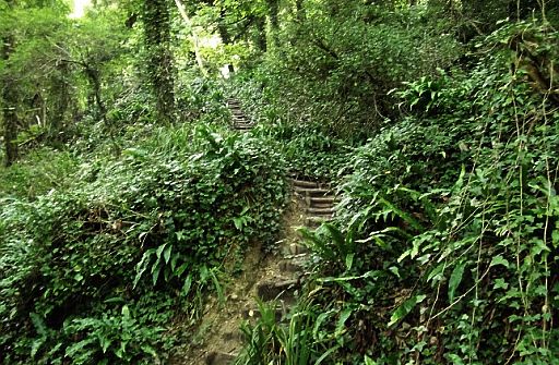
• Je loopt over een smal voetpaadje door een "jungle".
• Op deze foto zie je een van de vele traptreden met behulp waarvan men de ruggetjes
in het terrein
opklimt en afdaalt.
• Loop voorzichtig: op sommige plaatsen is het pad glad of
liggen er wortels bloot.
• Classic undercliff terrain:
an overgrown tumbled terrain on a clifftop ledge (=terras) backed by further, higher cliffs.
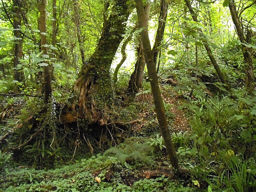
• The undercliff between Axmouth and Lyme Regis supports Britain’s largest self-sown Ash woodland.
Denk aan de woorden op :
www.southwestcoastpath.o..
The landslip east of Seaton can be, for some walkers, frustrating,
because:
• views of the sea are rare and glimpsed,
• an accurate idea of location is impossible and
• the environment can be claustrophobic for some and always a little forbidding.
| aaaa |
Coastal landslides:
De jurassic coast is
berucht vanwege de coastal landslides.
Zie bijv. www.bbc.co.uk/news/uk-e...
Drie bekende zijn:
Black Ven landslide complex.
.............................................
Stonebarrow Hill landslide...
............................................
Burton Bradstock rock fall.
Black Ven landslide complex:
• Between
Lyme Regis and Charmouth the weak beds of shales (=schalies) and marls(=mergels) give rise to one of
the
largest
coastal mudslides in Europe called Black Ven landslide complex.
• In 1958/9 two huge mudslides spilled out across the beach.
Today the boulder arcs exposed at low tide are all that remain from this
event.
• However these cliffs continue to move and it is only a matter of time
before the next 'big slip' takes place.
• The landslides vary in character and occur:
1. whenever sandstones overlie shales(schalies) and marls(mergels) and
2. where the cliffs are undermined by coastal erosion.
• At Black Ven the slips take the form of major mudslides that advance over the beach but elsewhere there can be sudden and dangerous rock falls.
.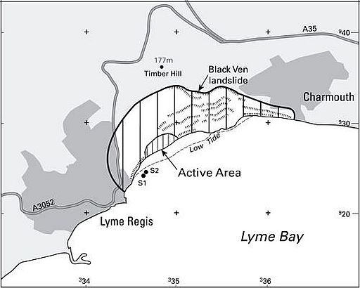
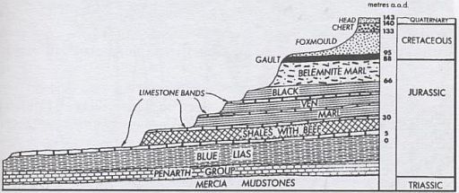
• Black Ven is a big, active landslide complex consisting of:
- an upper section in a sandstone known as Foxmould and
- a lower part consisting mainly of a series of shales(=schalies) and marls (=mergels) with
thin limestone (=kalksteen) bands that form benches in the landscape.
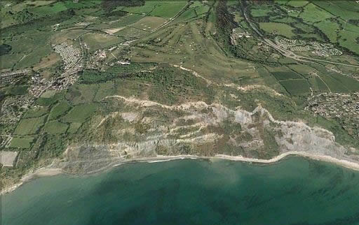
• In het midden zie je het Black Ven landslide complex.
• Links verschijnen de eerste woningen van Lyme Regis, en rechts die van Charmouth.
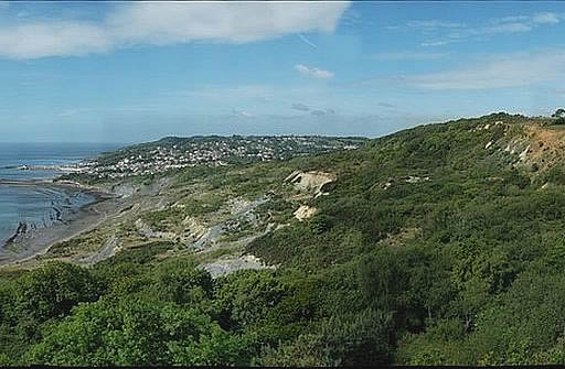
• Westwaarts kijkend vanaf Charmouth over Black Ven naar Lyme Regis.
| aaaa |
Chesil Beach . & . The Fleet:
http://mysite.du.edu/...
Chesil Beach:
• This is a shingle barrier beach (strandwal; lido) of 28 km (the largest
in Western
Europe !) running between West Bay and Portland.
(It is not a spit (schoorwal)!)
• A barrier beach(strandwal) is a gravel ridge (grindwal) that rises
slightly
above the surface of the sea and runs roughly parallel to the shore, from
which it is separated by a lagoon.
• The coarse gravel (grof grind) vary in size from pea sized at Burton
Bradstock to hen’s egg-size at Portland.
• Since Chesil Beach is so long (28 km), aerial photographs often give it
the appearance of being very narrow;
this is not the case.
In most parts the beach is 150 - 200 m wide and up to 13 m high.
• The seaward, southern side often takes a battering from the sea, but the lagoon side is afforded protection by the relatively high crest of the
beach.
• Building the beach:
The origin of Chesil Beach remains the subject of debate.
The traditional view is that the beach has been driven on shore by rising
sea levels following the last Ice Age.
• Hardy beach plants:
As the
beach is so exposed to south-westerly winds and sea spray, vegetation is concentrated on the sloping shingles facing The Fleet.
Plant colonization is also considerable greater at the Abbotsbury end, because the finer pebbles which occur here help to trap such organic matter as guano which enriches the soil and helps to retain moisture.
Vegetation is still sparse though, and the only plants to survive this harsh habitat are those that are tolerant of sea spray and can either root
very
deeply or withstand long periods of drought.
• Vogels: Chesil Beach is een belangrijk broedgebied voor het Visdiefje
en de Dwergstern. In het broedseizoen is het strand dan ook verboden terrein.
• A shingle beach (kiezelstrand) is a beach which is armoured with pebbles or
small- to medium-sized cobbles (as opposed to sand).
....Shingle (kiezelstenen) is a mixture of: |
...The Fleet:
• Protected partly from the sea by Chesil Beach lies The Fleet, a 13 km long tidal lagoon (getijdenlagune) composed of a series of narrows and
coves.
• It opens at its southeastern end
(at Weymouth) into the sea through a narrow bridged entrance less than 75 m wide.
At the northwestern, enclosed end is the famous Abbotsbury Swannery.
• At the Weymouth end, where the lagoon joins the sea, there is a tidal rush of immense power and range,
but at the Abbotsbury end the presence of normal tides is barely noticeble.
• There are extensive mudflats
at the Weymouth end which are exposed at low tide, but even at high tide The Fleet is extremely shallow, except for the deep channels between the mudflat.
• The Fleet is unique among British tidal lagoons in having a marked difference in salinity (salt concentration) along its length and contrasting conditions along its two main shorelines.
• The salinity in the lower third of The Fleet, near Weymouth, is much the same as in the English Channel, but in the upper two-thirds it can vary considerable depending on whether drought conditions or floods prevail.
In a drought the salinity might be a quarter that found in sea water, yet during floods this may be diluted to one twentieth of seawater salinity.
• The two long shorelines have very little in common, and thus add considerably
to the interest of the area.
The straight shoreline bordering Chesil Beach is composed predominantly of shingle whereas the opposite, landward edge is convoluted and offers a considerble variety of habitats ranging from saltwater and freshwater marsh to cliffs and cultivated soils.
 • West Bay and beyond taken from East Cliff (Je kijkt dus vanaf de clifftop westwaarts).
• The mouth of the West Bay harbour marks the north-west end of Chesil Beach.
• Het was een raar gezicht om zo'n enorme grindwal voor de bebouwing te zien liggen.
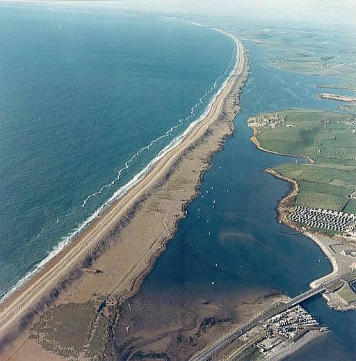 • A view of Chesil Beach & The Fleet, taken from above the Isle of Portland, near Weymouth.
• This shingle barrier extends some 28 km to West Bay in the distance.
• It affords protection to the tidal Fleet Lagoon and a low-lying hinterland.
• The beach maintains a continuous crest from West Bay at 6m O.D. rising to around 13m O.D. in the foreground of this photo.
• The surface is difficult to walk on; trying to cover any distance along the ridge is exhausting.
• The pebbles (grind) gradually increase in size from west to east.
• The pebbles (grind) near Chiswell, Isle of Portland.
• They are difficult to walk on because the rounded pebbles slide against each other.
• All material is hard and siliceous, mostly flint (vuursteen) and chert (silex; hoornsteen).
| aaaa |
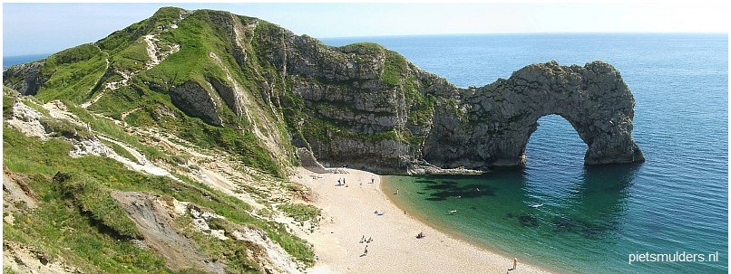
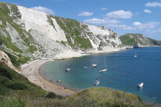
Van Durdle Door.naar Lulworth Cove:
• Durdle Door is an iconic image on the Dorset coast. This impressive natural rock arch (=brandingsboog) is formed due to the effect
of the erosive power of the
sea
on the vertical layers of different types of rock.
• It is part of only a small strip of hard limestone that is left here.
• The remnants of old arches can still be seen in the form of 'stumps' of limestone.
One day that is all that will remain of Durdle Door.
• St. Oswald's Bay is het resultaat van twee inhammen die tenslotte in elkaar zijn overgelopen.
In zee zijn nog resten van de relatief harde kalksteen te zien.
• At St. Oswald's Bay two old coves (=inhammen) have been eroded to form one with only a string of reefs (=klippen) showing where the hard limestone once was.
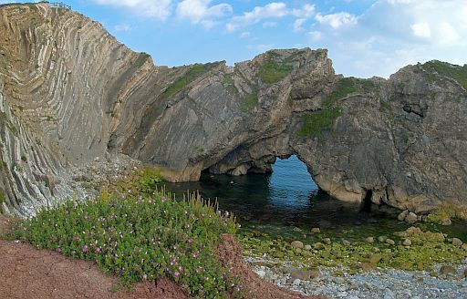
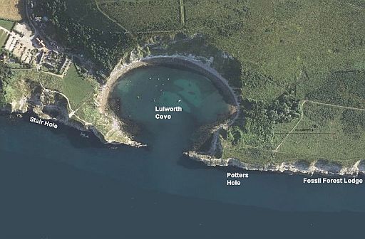
• At Stair Hole limestone was folded into these contorted (verwrongen) shapes during tectonic movements which formed the Alpine mountains, 30 million years ago.
• Door kusterosie ontstond in de kalksteen een brandingsboog.
• The limestone fractured and let in the sea - a new cove (=inham) in the making.
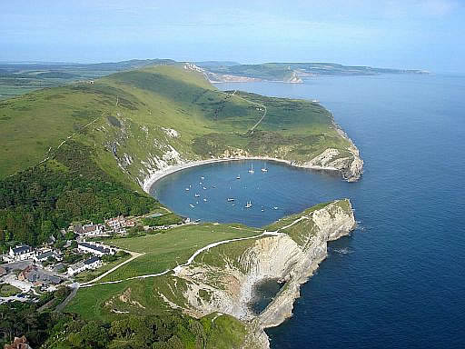
• Lulworth Cove. (Cove=inham; kleine baai)
• This rock formation is a perfect horseshoe bay formed around 10,000 years ago
when a stream breached the limestone cliff and the sea hollowed out the softer clays
behind.
• This process has happened in several places along the coast here and is still happening today.
For instance Stair Hole just west of Lulworth Cove (see photo) is a new cove in the
making. Eventually it will join up with Lulworth Cove.
•Lulworth cove (= inham) is een perfect hoefijzervormige inham langs
een steile kust met een nauwe doorgang naar open zee.
• De verschillende steenlagen lopen hier parallel aan zee en zijn door plooiing vertikaal komen te
staan.
• Een golf in de branding komt hier achtereenvolgens een relatief harde kalksteen,
de zachte zand- en kleilagen en tenslotte het weer iets hardere witte krijtgesteente van de Dorset Downs tegen.
Als de zee eenmaal door de relatief harde kalksteen heen is gebroken, vallen de zachtere klei- en
zandlagen snel
ten prooi aan de golven. Vervolgens loopt de zee zich weer vast op het ook beter weerstand biedende krijtgesteente.
• The impact of coastal erosion can be seen to great effect at Lulworth Cove.
Here, waves have cut through the resistant limestone and
eroded into
the softer sands and clays behind to form an almost perfectly circular
cove.
| aaaa |
Limestone areas in England and Wales:
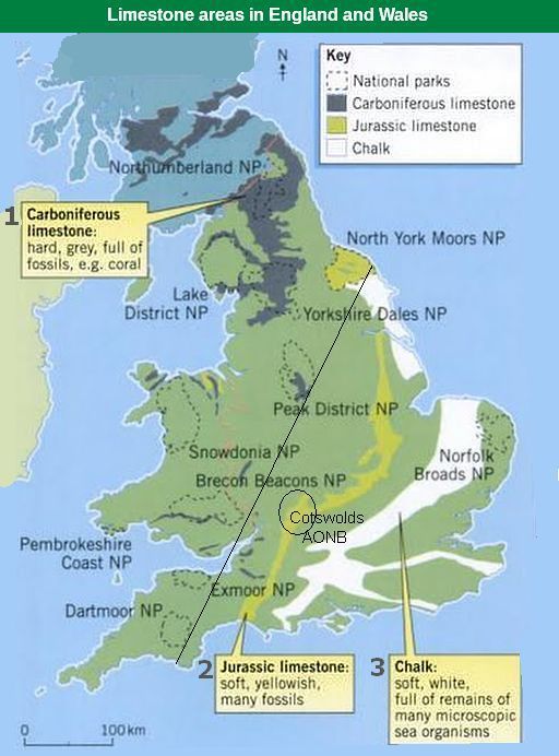
• There are three types of limestone in the British Isles, but the one that
forms
the highest upland areas is Carboniferous limestone (1) (kalksteen uit
het Carboon).
• Links van de diagonale lijn liggen de uplands (=gebieden hoger dan ongeveer 1,000 feet (± 300m) boven
zeeniveau.) De belangrijkste upland limestone landscapes in Engeland zijn: Northumberland NP , Lake District NP , Yorkshire Dales NP , North York Moors NP en Peak District NP.
• Je ziet op de kaart dat North York Moors NP wel uplands is (het ligt links van de diagonale lijn), maar geen Carboniferous limestone (1) heeft, In plaats daarvan
heeft ze de zachte, geelachtige Jurassic limestone (2).
Deze Jurassic limestone vormt een 500 km lang massief tussen Lyme Regis aan de zuidkust en Whitby aan de noordoostkust.
Ook de Cotswolds hebben die zachte, geelachtige kalksteen, maar omdat ze ten oosten van de diagonale lijn ligt, is het dus géén upland.
The map shows the three sedimentary rocks that are made from sea
creatures:
1. Carboniferous limestone
(kalksteen uit het Carboon: hard, grijs),
2. Jurassic limestone
(kalksteen uit de Jura: zacht, geelachtig) and
3. Cretaceous chalk
(krijt uit het Krijt: zacht, wit) ,
Jurassic limestone (2) and Cretaceous chalk (3) can hold water – they have tiny holes in them
and are very porous.
Carboniferous limestone (1)
Carboniferous limestone is not at all porous — although it is permeable (=doorlaatbaar) Water seeps through the joints.
The limestone is laid down in layers or 'beds' separated by bedding
planes (laagvlakken) and divided up into blocks by a series of joints (vertikale scheuren) (Joint = een vertikale scheur in een gesteente zonder dat het gesteente aan beide zijden verschoven is.)
These Joints in rock are caused by shrinkage or release of pressure as rocks above are eroded away. (Zie verder upland limestone landscapes)
A long time ago, about 350 million years ago (even before the
Dinosaurs) England was covered by a
shallow tropical sea – a bit like
where the Great Barrier Reef is forming today.
As the small animals and corals that lived in the sea died, their shells and skeletons fell to the bottom. A thick layer built up over millions of
years.
As it squashed and hardened, it eventually turned into limestone.
This Carboniferous limestone (1) is nowadays found in:
- northern
England (e.g. Yorkshire Dales, Peak district),
- Wales (e.g. Brecon Beacons) and in
- Ireland (e.g. The Burren).
| aaaa |
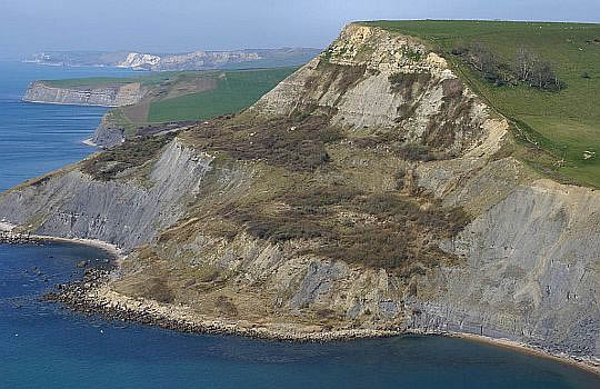
Old Harry Rocks (offshore chalk stacks).
Dorset AONB....16 km .. middelzwaar
At the eastern end of the Jurassic Coast towards Studland Bay, the chalk (=krijt) cliffs have been dramatically eroded into a series of offshore
chalk stacks (=brandingspilaren, klippen) called Old Harry
Rocks.
These stacks are famous landmarks (markante objecten) on the
Jurassic Coast.
(Dit stuk kust behoort ook tot de top-10 kwetsbare plekken kustafslag in Groot-Brittannië)
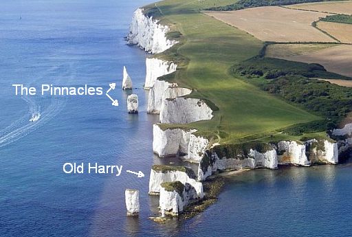
• Chalk (= krijt) cliffs and stacks at Handfast Point.
• Krijt is een fijnkorrelige, witte kalksteensoort, die uit de skeletten van
microscopisch plankton bestaat.
• Chalk is generally considered a soft rock, but it is surprisingly resistant to marine erosion.and
forms towering vertical cliffs along the coast.
• The string of sea stacks (brandingspilaren) that trail out onto the sea off the point here formed after the last ice age.
• Sea stacks like Old Harry form when slightly harder areas of rock resist erosion whilst everything else around them is worn away. Eventually these stacks will collapse but
new ones will replace them. Ongoing erosion like this is the main reason the coast is
so beautiful.
• At some point in the last 20,000 years the sea breached the chalk ridge that would have stretched across to the Isle of Wight.
It probably did this by flooding up river channels that had cut down through the chalk.
Once this natural barrier was breached the land behind was submerged, creating the
Solent. The chalk was slowly stripped back to create the coastline we see now.
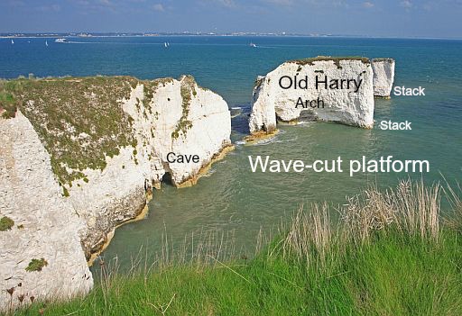
• A general view of Old Harry Rocks (a series of chalk stacks (=brandingspilaren). jutting into the sea.
• The progressive erosion of the headland can be seen, from
the caves (=brandingsgrotten) etched out at.the waterline, to the arch (=brandingsboog) on the
main stack, and eventually the isolated, pillars of
rock (brandingspilaren).
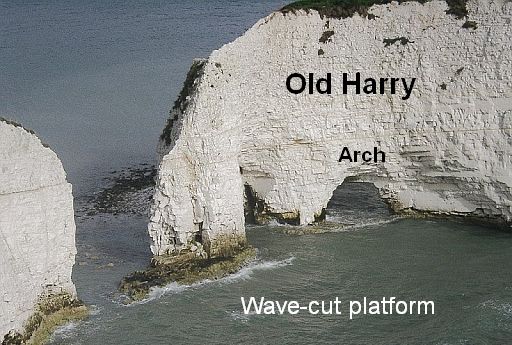
• A detail from the shot above, the stack (=brandingspilaar), arch (=brandingsboog) and some wave-cut platform (=brandingsplatform) , exposed at low tide.
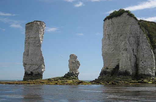
• Chalk stacks (=brandingspilaren) are formed where the sea erodes a
headland and isolates pieces of cliff.
| aaaa |
Van dag tot dag:
- Plan zodanig dat de Lulworth Ranges open zijn, als je daar aankomt.
Bekijk de exacte data op de website van het South West Coast Path:
www.southwestcoastpath...
They are open most weekends and at peak holiday times such as the
whole of August and bank holidays
Opening dates should be verified at the Lulworth Cove Heritage Centre.
- Onderstaande dagindeling volgt grotendeels:
www.hfholidays.co.uk/holid...
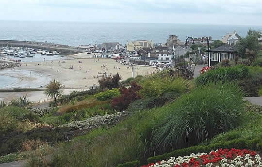
Arrival Lyme Regis.
- This is a delightful
seaside resort
with the partially medieval cobb (=havenmuur).
- The Lyme Regis museum is a great introduction and insight into the
natural history of the area.
- Here your first two nights accommodation has been booked.
1. Seaton ― Lyme Regis
... 11 ½ km...middelzwaar . ↑ 405 m
- Take in Lyme Regis a bus to Seaton.
(Eten en drinkwater meedragen voor de hele dag).
- Walk via the Axmouth-Lyme Regis U.. back:
This nature reserve is the 10 km coastal strip between these towns.
This unique environment was formed from landslides and is home to
many plants and animals with its mix of habitats including dense ash woodland.
You wander along paths through jungle-like woodland with
only occasional glimpses out to the coastline.
2. Lyme Regis ― Bridport
... 16 ½ km .. middelzwaar . ↑ 425 m
- “Rollercoaster” footpath.
-
Interesting sequence of cliff paths and smugglers’ villages such as
Charmouth and Seatown.
-
Als het getij het toelaat, loop je van Lyme Regis naar Charmouth
over.het strand !
Zo niet, dan doe je de inland diversion:
- Between Lyme Regis and Charmouth rock falls have necessitated an inland diversion from the coast. In that case the path heads inland
skirting Black Ven, the remains of the largest coastal mudslide in
Europe, before descending to Charmouth Beach, one
of
the best
places to find fossils on the Jurassic Coast.
- visit also Charmouth Heritage Coast Centre.
- If fossil hunting
doesn’t
distract you for too long, continue along the
cliffs to Golden Cap hill (191 m),
the
highest sea cliff in the south of
England with
splendid views all round.
Here Cretaceous sands sit on
top of Jurassic clays.
From here, we walk down into the hamlet of Seatown, before the next
hill takes us over to Eype and Bridport.
(Loop vanaf Eype
via holle wegen naar Bridport.)
3. Bridport ― Abbotsbury
..( 16 km ... middelzwaar ...↑ ... m
- Continue your walk heading along the coast towards Burton Bradstock (worth a visit ! )
with
its old spinning mill houses and thatched cottages
before
reaching Chesil Beach, (longest shingle beach in Europe)
- It is an 28 km stretch of flint (vuursteen) and chert shingle.
- It is uniquely separated from the
mainland by the Fleet Lagoon.
- From West Bexington we take the South Dorset Ridgeway (this is an
inland Coast Path section) to the
beautiful village of Abbotsbury.
This village has a
medieval tithe barn and swannery, the only one of its
kind where swans are bred.
-
There are plenty of sites here, especially we would recommend a stroll
up to St. Catherine’s chapel at sunset or dawn.
This chapel served as a lighthouse from monastic times and through
the destruction of the monasteries as a reference landmark for shipping. Recent storms have, however, caused the sea to breach the ridge and
form
a tidal lagoon on the marsh.
....Shingle (kiezelstenen) is a mixture of: |
......4. Abbotsbury ― Ellwell
.... 20 km..... middelzwaar .... ↑ 450 m
- Further on the South Dorset Ridgeway (an arm of the National Trail)
-
It offers a wonderful combination of views out towards Chesil Beach
and a chance for us to explore one of the UK’s most important ancient
ceremonial landscapes.
-
Neolithic, Bronze Age and Iron Age remains and constructions line our
route to the village of Elwell, just north of Weymouth.
-
We also pass the National Trust monument to the Battle of Trafalgar
hero, Thomas Hardy on its exposed setting above Portesham.
- Weymouth is an old seaside town.
There is plenty to enjoy in Weymouth including a wonderful beach
and a
lovely
harbour.
![]()
5. Weymouth―Lulworth Cove
.....17 ½ km......middelzwaar.....↑ 750m
- Follow the Dorset Coast Path eastwards along the white chalk cliffs
from Weymouth to Lulworth Cove.
-
This is another roller coaster day, but you can bypass the hilliest
sections with a more inland route.
-
On the way you pass the natural arches (rotsbogen) of Bats Head and Durdle Door and
the long abandoned medieval village of Ringstead.
Durdle Door is a 200ft high natural arch made up of chalk (krijt).
-
Just past Durdle Door, you enter the beautiful Lulworth Cove with its
azure waters and chalk hillside.
6. Lulworth Cove ― Worth Matravers
... 21 km ... zwaar......↑ ... m
- Draag levensmiddelen en drinkwater mee, want
er is geen supermarktje onderweg en
de eerste gelegenheid voor drinkwater
bijvullen is
pas bij de
Purbeck Marine Nature Reserve.
- Dit is een zware dag. Drie keer 140 hm steil omhoog
(Bindon Hill,
Rings Hill
en Houns-tout Cliff)
Daarnaast nog vele andere kortere
stijgingen.
- Leaving Lulworth Cove, you will enter Fossil Forest , the most complete
fossil record of a Jurassic Forest in the world.
-
Today’s walk does involve some careful planning as it takes you
through the Lulworth Ranges.
Please check notices locally as to the safe times you can cross.
- Head inland to the pretty village of Worth Matravers where you will
stay for the night.
7. Worth Matravers―Poole Harbour
.....23 km........middelzwaar .....↑.. m
- This walk takes you past Durlston Head which offers fantastic views of
the English Channel and the Isle of Wight before
-
continuing to the striking white sea stacks (brandingspilaren, klippen) of Old Harry and Old Harry's Wife which signify the end of your
journey. along the Jurassic Coast. (This area is a great place to spot bottlenose dolphins, pretty wildflowers and butterflies and so makes
for a very enjoyable final day.)
- Voorbij Studland liep ik over mooie paden midden door de Studland
Heath (de in het terrein gemarkeerde Heather Walk Trail) naar South
Haven Point.
( Daar kun je de veerboot nemen naar Poole.)
- Poole Harbour ( is a ria formed at the end of
the last ice age). (Ria = het verdronken buitenste deel van een rivierdal)
Bovenstaande dagetappes kunnen als leidraad dienen voor degenen
die
B & B boeken en dus met slechts een lichte dagrugzak lopen.
De wandelaars met trekkingrugzak en tent hebben zo'n indeling niet
nodig.
Zij zijn zo vrij als een vogel en kunnen 's avonds overal wel een tentplek vinden.
Ze doen er overigens wel goed aan 2 dagen extra te rekenen,
omdat je met een trekkingrugzak minder km's per dag aflegt dan met
een dagrugzak.
| aaaa |
SNP Natuurreizen heeft in Groot-Brittanië ook wandelreizen:
Hun reizen met een zwaarte van 1 of 2 zwarte cirkeltjes komen het beste overeen met mijn wandelingen.
Je maakt dan niet te veel hoogtemeters en wandeluren per dag.
Zie: www.snp.nl/reizen/
| aaaa |
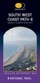
......Wandelgids: .................. Belangrijk: Strookkaart: Te bestellen bij: Reisboekwinkel de Zwerver ( webshop voor reisgidsen en landkaarten) |
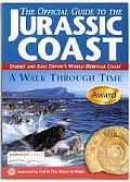
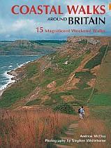
......Boeken met informatie over deze tocht: The Official Guide to the ... Coastal Walks Around Britain, .............. |
... Deze wandelsite is niet-commercieel, onafhankelijk en gratis. Dat is enkel mogelijk door steun van de bezoekers. Uiteraard kun je ook doneren door overschrijving op mijn ING-bankrekening: |
Weet je aanvullingen en verbeteringen van deze tekst?
Graag een e-mail naar:
![]()
![]() ....
.... ![]() ....
....![]()
LAATST BIJGEWERKT : 7-1-2019