..
......HADRIAN'S WALL PATH
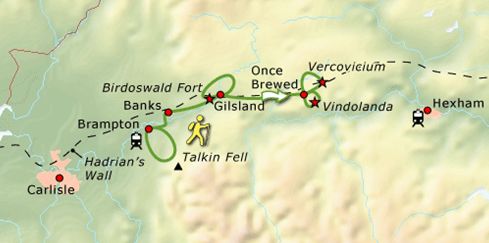
...... Brampton – Corbridge = 74 km
.
Hadrian's Wall:
.
• Hadrian’s Wall is gebouwd door de Romeinse Keizer Hadrianus.
Deze muur ligt
tussen de
Ierse zee en
de Noordzee en diende om de Picten
en Schotten buiten
zijn rijk te houden.
• Een prachtige wandelroute voert:
- langs de mooiste stukken van de muur,
- langs vriendelijke stadjes als Brampton,
- langs de restanten van 2000 jaar oude Romeinse forten,
- door het groene dal van de Irthing en
- langs de
de basaltformaties
van
de Whin Sill, waar de muur
zich van.haar imposantste kant toont.
Probably the most famous Roman remain
in England is Hadrian's Wall.
It is not by
any stretch the most northerly
point
of the Roman advance;
they reached as far
north
as modern
Aberdeen.
It isn't even the most northerly wall built
by the Romans in Britain.
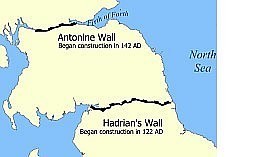
That honour
goes to the Antonine Wall, an earthwork
defense between
the
firths of Clyde and
Forth.
It is, however, an impressive engineering
feat, and well worth visiting.
| .. HADRIAN'S WALL : COMPLEET |
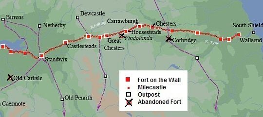
• De paarse streepjeslijnen zijn de Romeinse wegen.
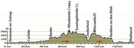
• At 326 m above sea level Winshields Crags is the highest point on Hadrian's Wall.
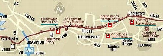
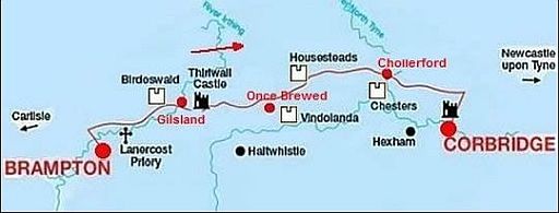
| .. MOOISTE DEEL:. BRAMPTON – CORBRIDGE |
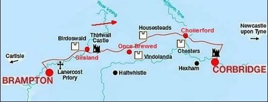
• De 4 forten (witte kasteeltjes) zijn Birdoswald, Housesteads, Vindolanda en Chesters.
• Dit mooiste deel ligt grotendeels nog juist in het Northumberland Na...
Zéér mooie video in de serie BBC Timewatch (48 min.):
www.dailymotion.com...
Mocht deze link geblokkeerd zijn, google dan naar: bbc timewatch hadrian's wall om hem via een andere link te bekijken.
Fotoalbums:
http://stuarthodgson.b...
............................................
www.ramblingpete.walki...
Emperor Hadrian:
The Emperor Hadrian came to the imperial throne in 117 A.D.
He decided that the Empire needed consolidation, not expanding, and
in 122 he
gave
the order to build a wall across the northern frontier.
They bild it eighty miles long, following the northern escarpment (cuestafront)
of the valleys of Tyne, Irthing, and Eden between Newcastle and Carlisle.
Construction:
The original construction took six years to complete.
The soldiers were working from east to west.
The wall was manned until sometime around 400 A.D.
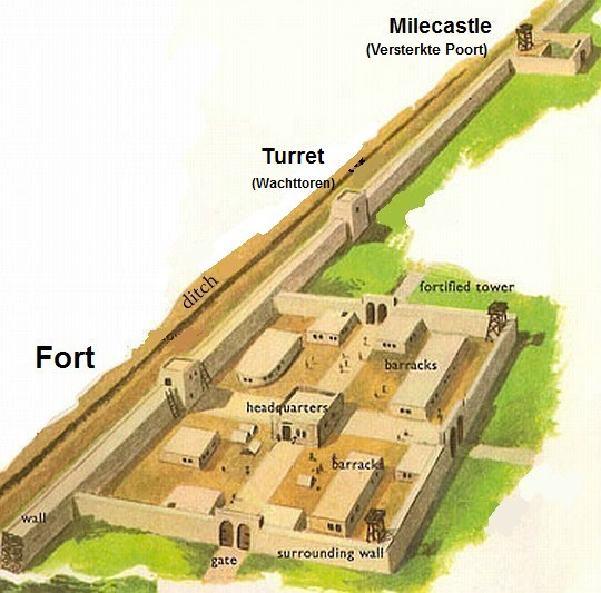
The Wall, Milecastles, Turrets and Forts
• The Wall itself was about ten feet wide and fifteen feet high, with a rampart
walk (weergang)
and six foot high parapet (borstwering).
• To the north lay a deep Ditch, except where the lie of the land made this unnecessary.
• There are over eighty Milecastles (=Protected Gates) (=Versterkte Poorten) at intervals of a Roman mile (± 1500 m).
These Protected gates (15 x 18 m) had a
kitchen
and
2
barracks for 10 to 30 soldiers.
• In between the Milecastles were 2 Turrets (=Wachttorens) built, resulting
in
lookouts every third of a mile for the entire length of the wall.
(Ze stonden dus 500 m van elkaar (zichtcontact!).
• In addition to the Milecastles there were 17 large Forts holding from
500 to 1000
troops, infantry or cavalry, or a mixture of both.
They were built into the wall, with a large gate on the north face
flanked by stone
towers. They ranged between 3 and 9 ha.
In het Latijn heetten ze "castellum". Zo'n Romeins fort was een legerbasis waar de
hulptroepen aan de grens van het rijk permanent verbleven.
(Ook in Nederland hadden we die forten langs de Rijn (nu de Oude Rijn, Kromme Rijn en Nederrijn): o. a. Castellum Trajectum onder het Domplein in Utrecht en Castellum Fectio (Fort Vechten) in Bunnik.)
Bij een "castellum" was ook een "vicus", een naastliggend dorp.
In dat dorp woonden veteranen, maar ook de vrouwen/kinderen van de militairen.
(Officieel mochten ze niet trouwen, maar ze deden dat vaak toch gewoon.) Ook was er in dat dorp een hele economie, die draaide op de naastgelegen basis.
Er waren handwerkers en handelaren; ook het voedsel van de soldaten
kwam er
vandaan.
.jpg)
• Reconstructietekening van een Milecastle (=Versterkte Poort (15 x 18 m).
• Zo'n Milecastle had een keuken en één of twee barakken. Er huisden 10 tot 30 soldaten.
• Iedere Romeinse mijl (± 1500 m) was er zo'n Milecastle. Hier werd gecontroleerd wie of wat het land in- of uitging.
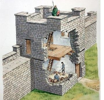
• Reconstructietekening
van
een Turret (=wachttoren) (330 x 330 cm).
• Tussen twee opeenvolgende Milecastles,
die
± 1500 m van elkaar
liggen, waren twee
Turrets geplaatst.
Dus alles lag op
zichtafstand
(=500 m)
van elkaar.
The Vallum: (= de sleuf aan de zuidzijde).
To the south of the wall the Romans dug a wide ditch, or vallum, with six foot
high
earth banks. Why a ditch to the south when the threat was to the north?
Volgens recente inzichten zou het gaan om een construction trench (=sleuf)
voor
een weg die nooit gerealiseerd is.
Zie: http://str
It comprises a flat-bottom ditch , roughly 6m wide and up to 3m deep, flanked
by
parallel mounds, set back about 9m from its edge.
These north and south mounds were built of spoil from the ditch and were
usually
revetted with turf, and occasionally stones.
There is often another small mound, known as the ‘marginal mound’, along
the
southern edge of the ditch.
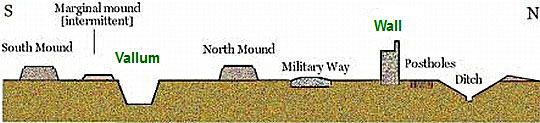
• Schematic section of the main features of the Vallum and Wall
Overblijfselen:
Vanzelfsprekend is er veel van de muur verdwenen. Maar wat overbleef,
is
spectaculair, speciaal in het Northumberland National Park.
Denk
daarbij aan gedeelten van :
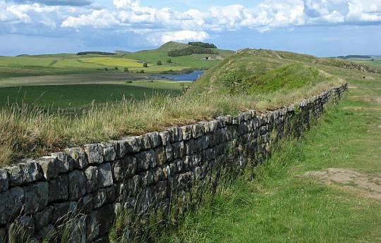
• the Wall (ongeveer 4 m hoog)
• Milecastles (=Versterkte Poorten)
• Turrets (=Wachttorens).
• the Vallum (de Sleuf) ten zuiden van de muur met de twee erlangs
liggende aardwallen).
• the Military Way: een later aangelegde weg tussen de 'Wall' en de.'Vallum',.
zodat de troepen snel verplaats konden worden.
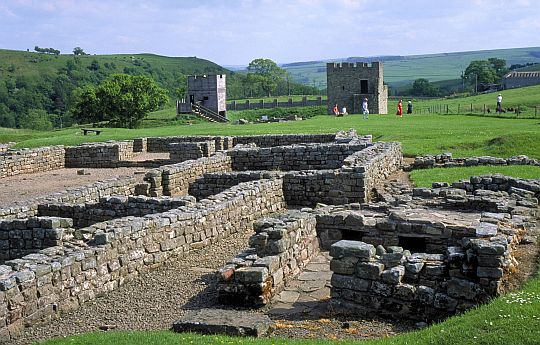
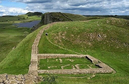
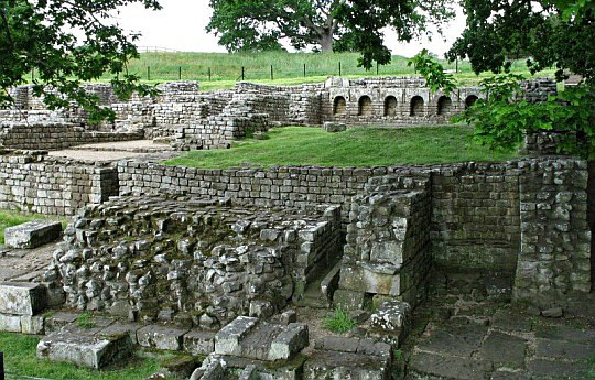
• Forts: (grote forten zoals Birdoswald, Vindolanda, Housesteads en Chesters).
Ze lagen ongeveer 7 mijl (± 10 km) uit elkaar en hadden een oppervlak
tussen 3 en 9 ha. In het Latijn noemde men ze castellum (mv: castella).
Daarnaast vind je bij het grote Chesters Fort ook nog:
• the Bathhouse
• the Bridge abutment (bruggenhoofd)
Loop voor deze laatste bij Chollerford over de brug.zuidwaarts.
Ga meteen voorbij de brug rechtsaf over een pad parallel.aan.de.rivier.
Following in the footsteps of Roman Legionnaires along Hadrian's
Wall:
In 2003 is langs de resten van die muur een officiële 'National Trail' geopend:
het
Hadrian's Wall Path.
Dit is een doorslaand succes gebleken.
Er komen 10 maal zo veel bezoekers dan verwacht.
Je zult dan ook zo nu en dan andere wandelaars zien.
Mooiste deel: Brampton – Corbridge.
Dit betreft het centrale deel.
Hier vind je:
de
beste overblijfselen in een prachtig landschap.
Dit gedeelte heeft top trail-allures.
De rest van het langeafstandspad heeft dat niet.
De muur is daar veelal
gesloopt
en je loopt
er over asfaltwegen in een stad of in doorsnee
platteland. Conclusie: sla die delen maar over.
The Hadrian's Wall Country Bus AD122
Er rijdt een speciale bus, de Hadrian's Wall Country Bus
(toepasselijk AD122 genaamd).
In 2019 als volgt: AD122 bus runs daily, from 19 April — 29 September 2019.
Haltwhistle – Walltown – Housesteads Once Brewed – Chesters – Hexham https://assets.goaheadbus.c...
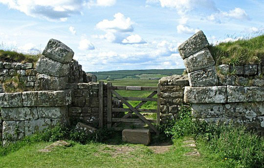
• Willowford (Bridge Remains)
.
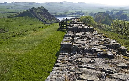
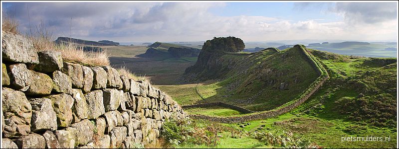
• The Whin Sill ridge stands out in the landscape as high and solid dark cliffs.
• It was used to great
advantage by the Romans who built Hadrian's Wall on top of it, making a ditch unnecessary.
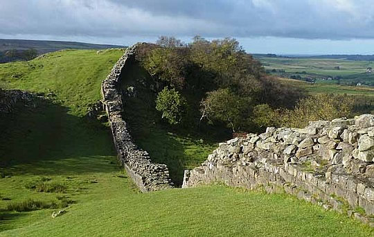
• Hadrian's Wall west of Turret 45A, looking west.
• Hadrian's Wall running along the top of the escarpment (=cuestafront) produced by the outcrop
(ontsluiting) of the Whin Sill.
• De muur wordt regelmatig met chemicaliën besproeid om plantengroei te verhinderen.
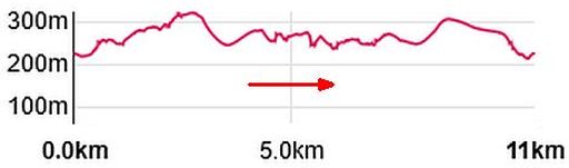
Lengte en tijdsduur: 74 km; 5 dagen.
Bij deze wandeltrektocht van 74 km zit ook de "detour" (uitstapje)
naar Vindolanda
(zie je
National trail
guide
blz. 84) en
de "detour" naar
Corbridge
(zie boek: blz 62).
Met een lichte dagrugzak loop je 74 km normaal gesproken in 3½ dag.
Hier
echter
heb je veel meer tijd nodig vanwege de informatieborden onderweg
en
vooral
het
bezoeken van de Romeinse Forten met 'Informationcentres'.
Reken
dus op 5 dagen.
Beste periode:
Half juni ― eind augustus is beste periode.
Mei is nog tamelijk koud.
September is minder geschikt om te kamperen, want:
1.
's morgens droogt je tent niet meer op voor 10.00 uur, zodat je ze nat moet inpakken.
2.
koude dagen behoren in september al tot de mogelijkheden.
3. 's avonds is het dan al vroeg donker.
(Voor het weerbericht ga je naar www.metoffi)
.Climate – Station Spadeadam (285m) |
apr |
mei |
jun |
jul |
aug |
sep |
okt |
.Gemiddelde maximumtemp. °C |
10
|
13
|
16
|
18
|
17
|
15
|
11
|
.Maandsom neerslag (mm) |
76
|
77
|
96
|
103
|
116
|
108
|
131
|
| ( Gem. maximumtemp. De Bilt ) | 14
|
18
|
20
|
23
|
23
|
19
|
15
|
Zwaarte:
Lichte dagwandelingen.
Het reliëf is vlak tot licht heuvelachtig.
Slechts bij de north-facing escarpment (=op het noorden gerichte cuestafront)
is er
een korte, steile klim
gevolgd
door
een afdalinkje.
• Vindolanda court.
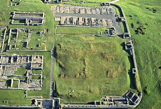
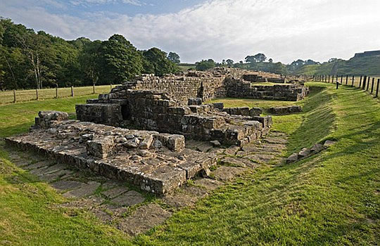
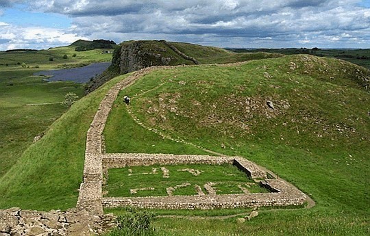
• Housesteads Fort from the air, looking north.
• Het was één van de 17 grote castella (=forten) die langs de muur werden opgericht.
• Op de foto zie je de rechtse (=oostelijke) helft van het castellum (fort).
• Rechtsboven aan de rand van de foto is nog een klein stukje van de
muur zichtbaar.
.
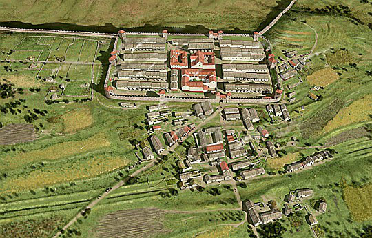
• Een reconstructie van het castellum (fort) met erboven de Muur van Hadrianus en eronder het naastliggende dorp, de vicus .
• De vorm van een castellum lijkt op die van een speelkaart: een rechthoek met afgeronde hoeken.
Kwaliteit van het pad:
Het wordt erg goed onderhouden.
Routemarkering:
Zeer goed. Ze is vrijwel overbodig. Een duidelijk donkergroen graspad
wijst je
de
weg
langs
muur
en/of
greppel.
Bevoorrading:
• Levensmiddelen: Er liggen hier weinig dorpen aan de Hadrian's Wall. Voor
levensmiddelen zul je dus
wel
een
keer
een "detour" moeten maken
naar
een dorp.
• Drinkwater: Je passeerde voldoende huizen onderweg.
ANWB Campings:
Zie voor een overzicht anwb.nl/engeland
Wildkamperen:
Een nachtje bivakkeren ('s avonds de trekkerstent opzetten en 's morgens
weer
afbreken) gaf geen problemen.
Hoogtepunten:
• Lanercost Priory. (zie kaartje hieronder).
The Priory was suppressed by Henry VIII, but remarkably, the church survives
to
its
full height, part now forming the parish church.
• Birdoswald Roman Fort (+ Visitor Centre)*** (zie kaartje hieronder).
It is one of the 16 Forts that were built at regular points along Hadrian's Wall.
It sits on top of the escarpment (=cuestafront) overlooking the River Irthing,
with
splendid views over the valley.
Within it lie the well-preserved remains of two granaries (=graanschuren).
• Roman Army Museum ****
• Vindolanda Roman Fort (+ Museum)*****
(met 5 sterren de beste site)..
• Steel Rigg car park ― Housesteads (5 km)
These offer some of the most exciting walking of the entire Wall.
It is strenuous, but the views are magnificent, over Crag Lough as well as the
wild
Northumbrian countryside. (Panoramapad!).
It is particularly interesting to note the way the Wall follows the land, rising over
the crags (= rotsen) and dropping into "gaps", where the Ditch usually
reappears
briefly.
• Housesteads Roman Fort (+ Museum) ****
Housesteads is the best-known Fort on Hadrian's Wall, perched high on the volcanic
escarpment (=cuestafront) of Whin Sill.
The Fort covers 2 hectares. There was a garrison for 800 soldiers.
• Chester Roman Fort (+ Museum) ***
Chesters Fort lies in the valley of the North Tyne river.
It has a well-preserved bath house and a remarkable museum built more than 100 years ago to house the great collection brought together by John Clayton.
Chesters Fort was a cavalry Fort.
• Corbridge Roman Site***
• The views along the wall from Peel Crags. (crags=rotsen).
.
• Hadrian's Wall and Milecastle 39 (Versterkte poort).
• Peel Crags provide a great view of the
Milecastle and to Crag Lough (looking eastwards).
• The Milecastle is situated in one of the gaps of the hillside.
• De meeste Milecastles werden niet op het beste uitzichtpunt gebouwd, maar volgens voorschrift op
1
Romeinse mijl (± 1500 m) van elkaar. Daardoor lagen ze soms op een ongeschikte plaats.
Een voorbeeld daarvan is Milecastle 39. Het had een
noordpoort met meteen ervoor
de
rand van de afgrond.
Extra dagen mogelijk in:
• Chollerford if you would like to explore Chesters Fort in depth.
It is an wonderful
Fort with some outstanding remains including an ornate headquarters building, the commanding officers residence, barrack buildings and
military bath-house.
The site
also has a unique museum that contains some of the finest Roman artefacts to be
found anywhere in Britain.
• The hamlet of Once Brewed is a good choice for a rest day if you want to fully
explore the Roman Forts of Vindolanda and Housesteads and visit their fascinating
museums.
• Many people take an extra night in Carlisle and visit the award winning Tullie
House Museum, the 12th century cathedral, the half-timbered
guildhall that
houses
a local history museum and the vast medieval castle,
with its ancient
chambers,
stairways
and the dungeons that contain the infamous
'licking stones'. Here,
parched
Jacobite prisoners found enough
moisture to stay
alive, only to be brutally
executed
on
Gallows Hill.
Van west naar oost:
Alle beschrijvingen zijn traditioneel van oost naar west. Denk bijvoorbeeld
aan
de
nummering
van de Turrets (Wachttorens) . Dit is één van de redenen
waarom een
aantal
wandelgidsen, waaronder de
National Trail Guide, die
richting
volgen.
Een andere reden is dat men liever eerst het zwakste gedeelte doet (=het
urbane
gebied
van Newcastle) en daarna het mooiste (=het platteland).
Loop dit middengedeelte echter liever van west naar oost, "with prevailing
wind
in
your back", zoals ook de Harvey strip map en het Hadrian's Wall
guidebook doen.
• At Milecastle 37 the north gate uniquely retains the lower arch stones on either side. (These arche stones have been replaced!).
.
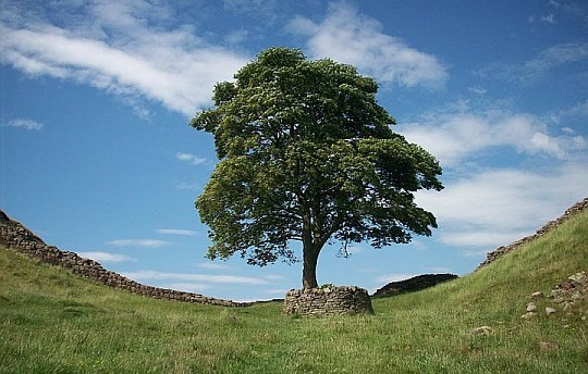
Sycamore Gap. This famous lone tree stands proud on this exposed section of wall. (Sycamore = Gewone esdoorn (Acer pseudoplatanus)
Overnachtingsmogelijkheden:
Dit is een populair pad.
Daardoor is het vinden van accommodaties moeilijk. Boek die tijdig..
Eindbeoordeling:
Dit deeltraject van Brampton naar Corbridge is een echte top trail.
Beste websites:
www.walkopedia.ne.. (korte introductie)
....................................
www.sherpavan.com
http://nl.wikipedia.o...
.....................................
www.ldwa.org.uk
Sites komen en gaan, dat valt niet bij te houden.
Googel daarom ook een keer naar hadrian's wall path en bekijk de eerste
10
(evt. 20)
resultaten. Daar zitten de belangrijkste sites wel tussen.
| aaaa |
Whin Sill:
The Whin Sill is one of the special geological features of the North
East England and forms some of the area's most dramatic landscapes.
Molten origins:
The hard, dark rock of the Whin Sill was once molten, but now stands
out
as spectacular craggy hills or cliffs.
The Whin Sill formed 295 million years ago when stretching of the
Earth's
crust caused molten rock, or magma, at over 1000 °C to rise up through
cracks in the rock
from
deep within the Earth.
It didn't reach the surface but was injected between layers of sedimentary
rock (=sedimentgesteenten) (limestone, shale and sandstone).
The magma cooled and solidified underground to form the Whin Sill –
a vast sheet (= plaat) of rock up to 60m thick, which lies beneath much
of North East England.
It is made of a hard dark igneous rock (=stollingsgesteente) and is much tougher than
the sedimentary rocks(=sedimentgesteenten) around.
After millions of years of erosion the Whin Sill is now partly exposed
at
the
surface as craggy hills or cliffs.
Igneous rocks (=stollingsgesteenten) Sedimentary rocks (=sedimentgesteenten) |
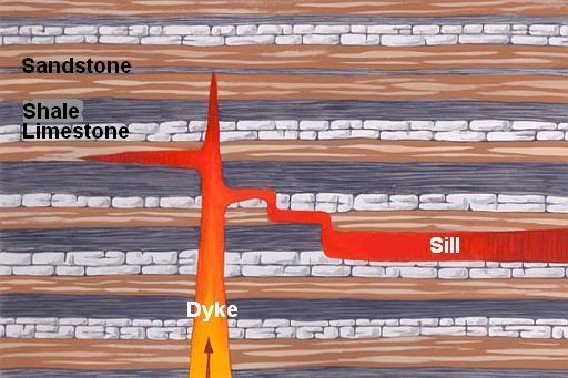
Dykes (= gangen) en sills:
.
• Dykes (= gangen)
They are formed as magma pushes up towards the surface through cracks in the rock and harden there.
They form vertical or steeply-dipping sheets (platen) (wall-like bodies)
of igneous rock (stollingsgesteente).
.
• Sills (= sills; intrusie-platen)
They are formed when magma intrudes (indringt) between the rock
layers and harden there.
They form horizontal or gently-dipping sheets (platen) of igneous rock (=stollingsgesteente).
Crystals and columns:
The Whin Sill is made of a hard, dark, crystalline rock (een basalt). As it slowly cooled, the Whin Sill contracted (kromp) , producing vertical cracks (scheuren) along which the rock breaks into rough columns (zuilen) (see picture below).
This is a distinctive feature of most Whin Sill outcrops (ontsluitingen).
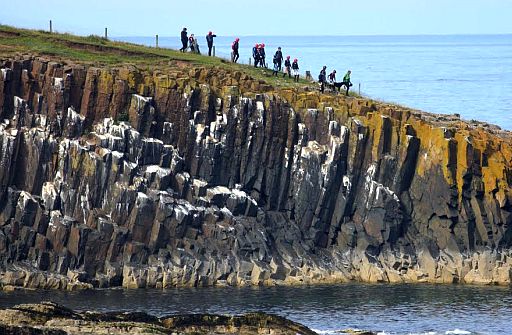
•Cullernose Point (Northumberland Coast Path) is formed from the Whin Sill.
• The Whin Sill probably took
around 50 years to cool from
molten rock to solid dolerite (dit is een basalt).
During the cooling
it contracted (= kromp) , producing vertical
cracks (scheuren) along which the rock breaks into rough columns (zuilen).
You
can see these cracks and columns in the cliff.
• Bij krimp, na stolling, van afkoelende vulkanische gesteentemassa's vormen zich vaak zuilen, meest 6-zijdige, ook wel 4-,5-, 7-, of 8-zijdige.
• During the summer months, the cliffs are home to kittiwakes (Drieteenmeeuwen) and fulmars (Noordse Stormvogels).
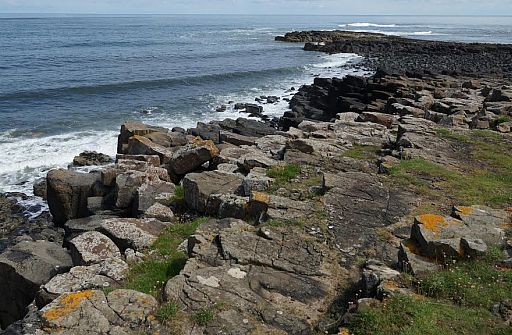
• Newton Point (Northumberland Coast Path) another example of Whin Sill.
• Ook hier krimpscheuren door afkoeling van een basaltlava.
The original sill:
The name 'Whin Sill' was first used by local quarrymen.
To them 'whin' was a hard, dark rock, and
'sill' was a term for a flat-lying layer of rock.
Geologists who studied the Whin Sill in the 19th century recognised its molten origins and the term 'sill' was adopted for all similar bodies of igneous rock(=stollingsgesteente).
The Whin Sill is thus the original sill of geological science and is well
known to geologists worldwide.
| aaaa |
The central section of Hadrian’s Wall was built
along a natural line
of north-facing escarpments (cuestafronten):
.
• These cliffs are formed by the outcrop (ontsluiting) of the Whin Sill.
• The Whin Sill is here about 30 m thick and made of dolerite which is like basalt but has coarser grains as it cooled slowly underground.
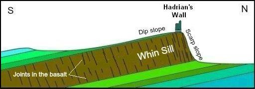
• The diagram above is a cross-section through the sill, showing how this rock breaks along joints to form the cliffs on which the wall is built.(As it cooled, the Whin Sill contracted, producing vertical
cracks along which the rock breaks into rough columns.)
• After the intrusion all the layers have been gently tilted and nowadays the sill dips gently to the south beneath the overlying sedimentary rocks.
• The north-facing cliff is very steep due to the near-vertical joints in the sill.
• Hier is dus sprake van een cuesta met een Dip slope. en Scarp slope.
Vergeleken met de hoge cuesta's van de South Downs, Cotswold Hills en de North York Moors, (alle drie meer dan 100 m hoog), is deze van de Hadrian's Wall slechts bescheiden (± 40 m).
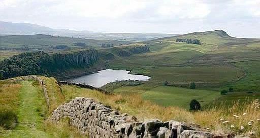
• Crag Lough from the east.
• Because of the hardness of the dolerite when compared with the surrounding sedimentary rocks, the Whin Sill forms a series of ridges in the landscape, particularly in the area between Steel Rigg and Sewingshields Crag.
• These Whin Sill ridges stand out in the landscape as high and solid dark cliffs.
• Hadrian’s Wall was built here, as these ridges offered extra protection against attack.
| aaaa |
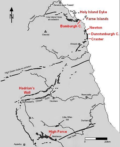
Where to see the Whin Sill:
.
• The Whin Sill extends over a large area from Middleton in Teesdale
in the south to Berwick in the north.
• It varies from 30 m to about 60 m in thickness, and gradually thins as
it goes westwards.
• However, in most places the sill of dolerite is not seen on the surface .of the ground, but remains covered by the carboniferous rocks.
• Only in a few areas it has been exposed by the erosion of overlying .rocks.
In that case, the hard, dark-coloured dolerite, which is very resistant
to erosion, stands out as craggy hills or cliffs in the landscape.
• Because of its resistance to erosion this dolerite, forms:
- islands: e.g. Farne Islands,
- ridges: e.g. Hadrian's Wall,
- waterfalls e.g. High Force.
- the base for castles: e.g.
. Bamburgh Castle,. Dunstanburgh Castle and. Castle on Holy Island (The last one is not sited on a sill but a dyke).
| . Situeringskaart Whin Sill ( Dolerite ) ontsluitingen: |
.
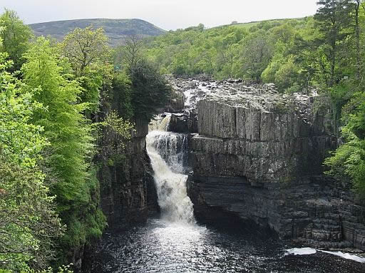
• The Whin Sill is also responsible for one of Britain’s most famous waterfalls: High Force.
Here the River Tees falls more than 20 m over the resistant rocks of the Whin Sill.
• Two types of rock can be seen at the falls:
1 The lower rocks are horizontal sediment layers.
2 The upper rocks are dark dolerite and has vertical joints. They are much harder than the sediment layers underneath.
• This tough dolerite is resistant to erosion, which explains the location of the waterfall.
Where there is no dolerite, the valley broadens out and waterfalls are absent, but other bands of dolerite create waterfalls just a short distance upstream at Cauldron Snout and downstream at Low Force.
| aaaa |
SNP Natuurreizen doet ook het mooiste deel van
Hadrian's Wall Path:
Zie : www.snp.nl/reis/g...
Mooie, rustige wandelvakantie langs de restanten van de 2000 jaar
oude,
Romeinse muur van Keizer Hadrianus.
Forten, en muren met wachttorens, maar ook boeiende musea brengen de
Romeinse tijd tot leven.
De ruïnes maken deel uit van het prachtige landschap in
Noord-Engeland.
Dit alles aan de hand van het boek 'Een grens van Steen' van Herman
Vuijsje.
.. 
Aankomst Brampton:
Aankomst in het historische marktplaatsje Brampton, het beginpunt
van
deze wandelreis.
Kom je al vroeg aan in Brampton, dan kun je misschien nog een korte wandeling maken in de directe omgeving.
Onderweg kom je dan langs de 12e eeuwse Old Church die opgebouwd
is
uit stenen van een vervallen Romeins fort, loop je door weilanden en
een
stukje over de ‘Stanegate’, een Romeinse verkeersweg.
Op het eind van de wandeling beklim je de stuwwal ‘Brampton Ridge’, waar je een prachtig uitzicht hebt over Brampton en omgeving.
Wandeling: 7 of 9 km, 80 m stijgen, 3 of 4 uur.
1. Rondwandeling ten zuiden van Brampton
... 21 km..... ↑ 280m
Hier heb je een zacht glooiend landschap. De wandeling voert door de uitgesleten kloof van de 'River Gelt', door ‘Gelt Woods’ met veel
'wildlife',
door weidelanden en gemengd bos en langs de rand van de
uitgestrekte
veen-heidevelden van de 'Talkin Fell'.
Hier kijk je uit over het brede dal
van de ‘River Eden'.
Tot slot wandel je langs de groeves waar de Romeinen zandstenen
wonnen
voor de Muur van Hadrianus.
Via een ezelpad waarover ze die stenen vervoerden ga je terug naar
Brampton. Er zijn mogelijkheden deze wandeling in te korten.
2. Brampton ― Gilsland
.. 16 km ...... ↑ 280m
Vandaag maak je een pittige wandeling. Eerst vanuit Brampton
omhoog
naar ‘The Mote’ en de stuwwal ‘Brampton Ridge’, vanwaar je
mooie
vergezichten hebt over de omgeving. Dan omlaag over ‘public footpaths’ door het beboste dal van de Quarry Beck naar de
12de-eeuwse Lanercost Priory. Hier kun je pauzeren in de tearoom,
de kerk en de
overblijfselen van de priorij bezoeken. In de middag stuit
je op de eerste
sporen van de Muur van Hadrianus, die hier ooit uit
plaggen opgebouwd
was. Dan weer omlaag door het beboste dal van de ‘River Irthing’, over
het dalende en stijgende ‘public footpath’ langs
deze slingerende rivier.
Tot slot weer omhoog langs een van de langst
aaneengesloten stukken
van de stenen Muur met een prachtige Vallum
aan de zuidkant,
wachttorens en de ruïnes van het Birdoswald Roman Fort.
Vandaar is het nog een korte klim naar je accommodatie in Gilsland.
3. Rondwandeling vanuit Gilsland
... 9 km/14 km ......↑ 225m/275m
Vandaag maak je kennis met het landschap rondom het dorpje
Gilsland.
Na een interessant bezoek aan Birdoswald Roman Fort loop je langs
de imposante, nog originele resten van de Muur met wachttorens en een ‘milecastle’ (versterkte poort) en krijg je een indruk van de
Romeinse brug
over de ‘River Irthing’.
Via Gilsland wandel je het diep uitgesleten dal van de 'River Irthing' in,
waar Sir Walter Scott een romance beleefde.
Hier kies je voor een kortere of langere wandelroute:
- langs de andere kant van het dal terug naar Gilsland, of
-
een stuk over de venige Moors, een open ruig landschap van leegte
en
eenzaamheid naar de Crammel Linn waterval.
Tot slot bereik je via het rivierdal en het voormalig 'kuuroord' Gilsland
Spa
je accommodatie.
4. Gilsland ― Twice Brewed
... 16 km .....↑ 320m
Vandaag wandel je de hele dag langs de Muur van Hadrianus.
De Muur doet zich in verschillende gedaanten aan je voor: soms loop
je
langs de best bewaarde stukken, dan weer lijkt hij op een ‘grasdijk’,
een
boerenmuurtje of is hij ‘verkruimeld’ tot een zielige hoop
losliggende stenen.
Onderweg loop je ook nog tegen de mysterieuze restanten vanThirlwall Castle aan.
Tussen Gilsland en Twice Brewed passeer je de restanten van
wachttorens,
'milecastles' (versterkte poorten) en forten, waaronder
de ruïnes van het
legerkamp Aesica. Je volgt de Muur hier langs de
oude Romeinse militaire
weg vlak onderlangs en over het
Hadrian’s Wall Path dat de Muur hier
nauwgezet volgt over de
langgerekte, pittig op en neer gaande basalten ‘Crags’.
De wandeling eindigt bij je accommodatie bij Twice Brewed of in de
buurt
van
Henshaw.
5. Rondwandeling vanuit Twice Brewed
... 15 km .. .. ↑ 275m
Ook op deze laatste wandeldag weer volop aandacht voor de
aanwezigheid van
de Romeinen aan de noordgrens van hun Rijk.
Vanuit Twice Brewed kun je een bezoek brengen aan het bekende
legerkamp ‘Vindolanda’ met bijbehorend museum en herbeleef je
het Romeinse leven
aan de Muur.
Door de weilanden wandel je
daarna omhoog langs de nog
intacte Muur op de Highshield Crags
naar de ‘Sycamore Gap’, met de meest
gefotografeerde boom van
Engeland.
Langs het Hadrian’s Wall Path kun je naar de verderop en prachtig
gelegen
legerplaats Housesteads (‘Vercovicium’) gaan, waarvan de
restanten ook
een interessant beeld geven van het dagelijkse
militaire leven.
Of je slaat eerder noordwaarts af over de ‘public footpaths’ door
uitgestrekte
weilanden en langs Crag Lough. Zo zie je de Crags ook
eens van een andere
kant.
Via Steel Rigg wandel je tot slot weer terug naar je accommodatie bij
Twice Brewed of Henshaw.
- 'The amount of uphill walking' blijft beperkt, zie bovenstaande cijfers.
- De hoogtepunten zijn:
1. de overblijfselen van de muur en
2.
het mooie landschap,
3. de bovenstaande "groene" monumenten. .
..
| aaaa |
Van dag tot dag volgens www.hfholidays.co.uk
1. Brampton ― Gilsland
... 14½ km .....licht..... ↑ 390m
Walk from the historic market town of Brampton, to the spa village of Gilsland, exploring the ruins of Lanercost Priory, and the Birdoswald Roman fort en route.
2. Gilsland ― Once Brewed
... 16 km ......licht..... ↑ 400m
Leaving Gilsland the route becomes more dramatic. After the ruins of Thirlwall Castle, the stunning scenery of Walltown and Cawfield Crags greet walkers en-route across the moors to Once Brewed.
3. Once Brewed Circuit
... 12 km ......licht...... ↑ 295m
The most stunning section of the route. The walk crosses the rugged
outcrop
of Whin Sill, traversing above the beautiful lake of Crag Lough,
and passing
the
famous Robin Hood’s tree, before reaching the Roman forts of Vindolanda and Housesteads.
4. Housesteads ― Chollerford
... 16 km .....licht...... ↑ 155m
Over Sewingshields Crag for great views of Hadrian’s Wall zig-zagging
fore
and aft. Our walk continues past the fort of Brocolitia, the Temple
of Mithras, and Chesters Roman fort with its walled herb garden,
en route to Chollerford.
5. Chollerford ― Corbridge, via Aydon Castle
... 15 km ...... licht...... ↑180m
The final day is a pleasant walk through farmland and forest. Impressive Aydon Castle, setting for the film ‘Ivanhoe’, is a fitting finale before we
complete our trail at medieval Corbridge.
| aaaa |
Mooiste dagwandeling van Hadrian's Wall Path:
Housesteads ― Steel Rigg,
.
Northumberland N.... 10½ km ...licht
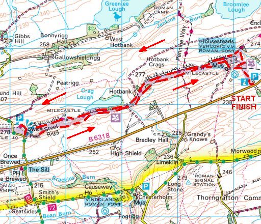
......... Totale stijging = 430 m
This short circular walk explores the most dramatic section of Hadrian’s Wall, an 84-mile route that was once the northern frontier of the mighty Roman Empire.
You’ll find history every step of the way if you walk the entire Hadrian’s Wall National Trail from the Cumbrian coast to Newcastle, passing the remains of Roman settlements and forts and tiptoeing along sections of the legendary wall that still stand to this day.
But if you don’t fancy the whole Hadrian’s Wall path, this 7-mile circular route near the town of Haltwhistle in Northumberland covers arguably its most dramatic section.
Starting at Housesteads Visitor Centre and crossing Hotbank Crags on the way to Steel Rigg, you’ll pass historical landmarks and dramatic natural features including one of Britain’s most photographed trees at Sycamore Gap (one for the Robin Hood Prince of Thieves fans out there!).
You’ll return on the Roman Military Way, and go home with your head
full of history and tales to tell your friends.
• Start / finish:
Car park at the Housesteads Visitor Center.
• The Outdoor Guide verdict (= oordeel):
This bitesize section of the Hadrian’s Wall National Trail crosses some
of England’s most dramatic and historical landscapes in just a few
short miles.
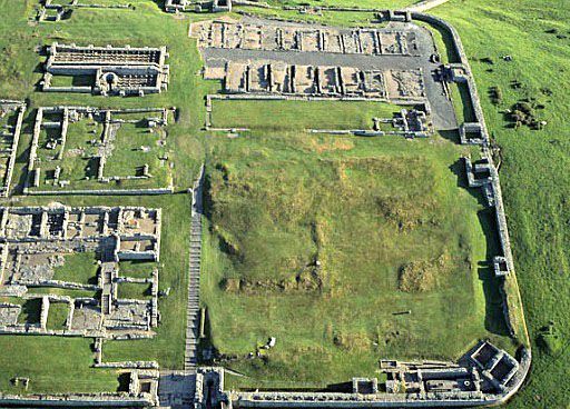
• Housesteads Fort from the air, looking north.
• Het was één van de 17 grote Castella (Forten) die langs de muur werden opgericht.
• Op de foto zie je de rechtse (= oostelijke) helft van het Fort.
• Rechtsboven aan de rand van de foto is nog een klein stukje van de
Muur zichtbaar.
• Hadrian's Wall and Milecastle 39 (Versterkte poort).
• Peel Crags provide a great view of the
Milecastle and to Crag Lough (looking eastwards).
• The Milecastle is situated in one of the gaps of the hillside.
Verdere info:
www.pietsmulders.nl/eng...
............................................
Mooie video, waar men in ....
..............................................
https://en.wikipedia.org...
............................................
https://osmaps.ordnancesu...
Wandelgids: Kaart: OS Explorer OL43 Deze heb je nodig als je van Greenhead-Walltown naar Old Repeater Station loopt. Voor de korte wandeling van Housesteads naar Steel Rigg voldoet bovenstaande kaartfragment. Te bestellen bij: Reisboekwinkel de Zwerver ( webshop voor reisgidsen en landkaarten) |
| aaaa |
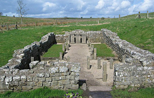
• The ruins os a Mithraic temple lie beside the Roman fort of Brocolitia. It is a small temple to the god Mithras.
• Inside were three reproduced statues, one of
which had holes which would have been illuminated
from within.
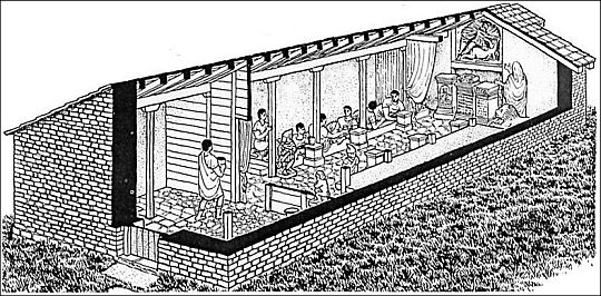
• Mithraeum reconstruction.
• The bath house at Chesters Fort, with the latrine in the foreground, the changing room beyond and
the steam range to the left.
Wandelgids: Strookkaart: De symbolen Campsite en Foodshop worden op deze strookkaart wel
erg
snel toegekend.
Ik zag bijv.
bij een
huis het achtergazon veranderd in een.camping
door
er slechts
een toiletje
zonder douche bij te zetten. Bovenstaande is te bestellen bij: Reisboekwinkel de Zwerver ( webshop voor reisgidsen en landkaarten)
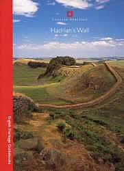
Deze informatieve bezoekersgids van
English Heritage is handig om op zak te
hebben bij een bezoek aan de muur of
een van de forten. |
... Deze wandelsite is niet-commercieel, onafhankelijk en gratis. Dat is enkel mogelijk door steun van de bezoekers. Uiteraard kun je ook doneren door overschrijving op mijn
ING-bankrekening: |
| aaaa |
Reactie van Han Knols:
Geachte heer Smulders
Ik overweeg om de wandeling te maken, maar ik maak mij wat zorgen
over de drukte, omdat ik geen zin heb om “file te lopen”.
Kunt u mij een indicatie geven van het aantal mensen dat ik – laten wij
zeggen – elke honderd meter tegenkom?
Met vriendelijke groet,
Han Knols
Beste Han,
Toen ik hem liep, zag ik wel eens in de verte één of meer wandelaars.
Het was echter veel minder druk dan bijv. op de GR 65, waar je wel
iedere
paar honderd meter iemand ziet lopen.
Natuurlijk zijn er wel een aantal mensen aanwezig bij de forten en musea.
Groet,
Piet Smulders
| aaaa |
Weet je aanvullingen en verbeteringen van deze tekst?
Graag een e-mail naar:
![]()
![]() ....
.... ![]() ....
....![]()
LAATST BIJGEWERKT : 7-1-2019