...
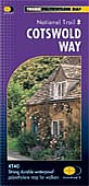
........... COTSWOLD WAY
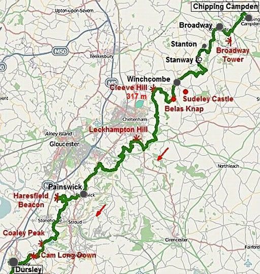
... Chipping Campden – Dursley.=.5 dagen
.
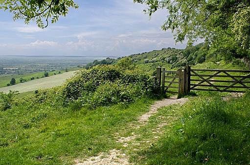
Along the Cotswold escarpment (=cuestafront) with its stunning views and charming villages.
• The Cotswolds is a limestone plateau with an escarpment (=cuestafront) on the western edge..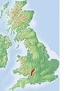
• The Cotswold Way follows this west-facing escarpment.
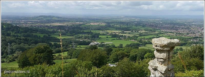
There are many panoramic views across the Severn Plain (Bepaalde gedeelten kun je dan ook panoramapad noemen).
• The cuesta is a long ridge, composed of gently (slechts enkele graden !) dipping (hellende) beds of rock.
One side of the ridge is a long, gently (flauwe) slope (dip slope) and the other side of
the ridge is very steep (escarpment, scarp slope) (=cuestafront).
Dit cuestafront vormt een abrupte scheiding tussen het hooggelegen Cotswold Plateau en de laaggelegen Severn Vale.
(Zie verderop de tekst van cuesta in een kader).
• De Cotswolds is een gebied met het predicaat AONB (‘Area of Outstanding.Natural Beauty’ ; this is the next step down from a
National Park)
Typische Cotswoldsdorpjes, en erkende toeristentrekkers, zijn Bibury en Bourton-on-the-Water. Net zo karakteristiek en net iets minder platgelopen zijn Broadway, Chipping Campden en Northleach.
The Cotswolds is a gentle quintessentially English landscape of rolling hills They are typified by yellowish (honey-coloured) Cotswold stone.
We find here:
1. an idyllic, rural countryside with hedged fields and
beechwoods (=loofbos gedomineerd door
Beuk).
2. History: Iron Age hillforts (= hillforts , walburchten) and Neolithic Long barrows, (=langgraven) as well
as stately homes.
• The Cotswolds are hilly rather than mountainous - the
highest point Cleeve Hill being 330 m above sea level.
(De Cotswolds behoren dus niet tot de uplands d.w.z. land lying above the limit of enclosed (omheind) farmland. Die grens ligt gewoonlijk op grofweg 1,000 feet (±300m) boven
zeeniveau. De Cotswolds
blijven daar grotendeels onder.
• In the 17 th century the Cotswolds derived their prosperity from wool trade; today the chief glory of the area lies in its villages,
which have survived unspoilt into the 20th century.
| .. COTSWOLD. WAY :.. CHIPPING CAMPDEN – DURSLEY |
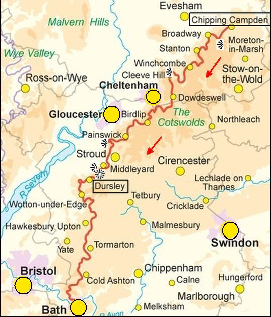
• Er zijn veel uitzichtspunten. In de kaart staan alleen de bekendsten, o.a. Cleeve Hill 315 m
.
Je blijft bijna de hele tijd lager dan ongeveer 1,000 feet. De Cotswolds is dus géén upland.
Fotoalbum:
www.ramblingpete.walk...
Mooiste deel:
Van Chipping Campden naar Dursley.
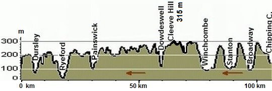
Lengte en tijdsduur: 101 km.
• Als je deze wandeltrektocht met een lichte dagrugzak loopt , terwijl je de hoofdbagage laat bezorgen, kun je het traject in 5 dagen doen (zie verderop bij Van dag tot dag).
• Ga je echter met trekkingrugzak en tent dan heb je zo'n indeling niet nodig. Je bent dan vrij in doen en laten en kunt 's avonds altijd wel een tentplek vinden. Je hebt dan wel 2 á 3 dagen méér nodig, omdat je met een trekkingrugzak minder.
Beste periode:
Dat is Juni, juli, augustus.
Mei en september zijn overgangsmaanden. Mei is nog tamelijk koud en september al vroeg donker.
Regen valt er hier weinig.
(Voor het weerbericht ga je naar www.metoffice.gov.uk/)
.Climate – Station Cheltenham (58m) |
apr |
mei |
jun |
jul |
aug |
sep |
okt |
.Gemiddelde maximumtemp. °C |
14
|
17
|
20
|
22
|
22
|
19
|
15
|
.Maandsom neerslag (mm) |
48
|
53
|
50
|
50
|
55
|
52
|
60
|
| ( Gem. maximumtemp. De Bilt ) | 14
|
18
|
20
|
23
|
23
|
19
|
15
|
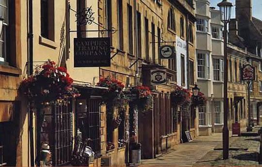
• The High Street in Chipping Campden.
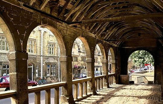
• The ancient Market Hall was built in 1627. It was for the purpose of giving shelter to the local market selling cheeese, butter and poultry - not wool as is sometimes thought.
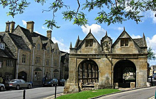
• Market Place in Chipping Campden with buildings of honey-coloured (honingkleurige) limestone. On the right you see The ancient Market Hall.
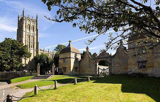
• St. James Church (met zijn stompe, vierkante toren) en rechts de Gate Houses.
The Cotswolds:
• The Cotswolds form part of an extensive belt of limestone (a cuesta) that runs from Dorset in the south to Yorkshire in the north. (Zie kader verderop).
• The highest and broadest part of this belt is an undulating tableland, rised on its western side and draining gently towards the east, down to the Thames Valley and the Oxfordshire Plain.
• On its western side, the escarpment falls abruptly to the Severn Plain, revealing its most dramatic features.
• The Cotswold landscape and its buildings owe everything to this underlying bedrock of honey-coloured limestone. It characterises the region's picturesque churches and cottages.
• Numerous mounds provide evidence of a long history of occupation along the very rim of the escarpment (= cuestafront), from which early man scanned the broad. views, alert to approaching danger.
• (Zie ook wat Cicerone schrijft onder het hoofdstuk The landscape blz. 16).
Zwaarte:
Middelzware dagwandelingen.
Elke dag klim je wel een paar keer van de voet van de escarpment (=cuestafront)
naar de edge (bovenrand). Daar blijft het niet bij, want de route kent nog een groot aantal kleinere klimmetjes in dit golvend terrein.
Routemarkering:
Zeer goed, zoals alle "national trails".
Bevoorrading:
• Levensmiddelen: Geen probleem: je passeert de meeste dagen wel een dorpje of marktstadje.
• Drinkwater: Er waren voldoende huizen onderweg, waar je dat kunt vragen.
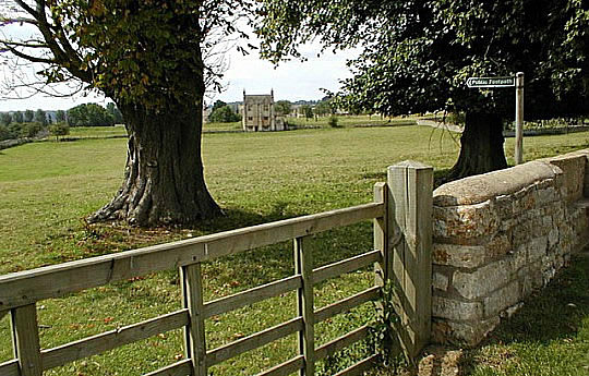
• Church fields near Chipping Campden.
ANWB Campings:
Zie voor een overzicht anwb.nl/engeland
Campings zijn er weinig. Ze staan ingetekend in je Harvey-strookkaart.
Wildkamperen (bivak):
Gaf mij geen problemen. In het agrarisch gebied waren er genoeg plekken (gemaaide weilanden). Zoek op je Harvey-strookkaart naar een beek om je te wassen. Wanneer die er niet was, vulde je bij een huis je waterzak. Hiermee kun je je voldoende wassen voor een enkele keer.
Hoogtepunten:
• Chipping Campden
• Stanton, veel woningen zijn hier opgekocht door rijke stedelingen die er alleen in het weekend zijn.
• Stanway House
• Leckhampton Hill― Cooper's Hill/A46. 14 km
(high along wooded scarps).
• Painswick ― Stonehouse/A46 ... 14 km
(more wooded scarps).
- Painswick,
- Haresfield Beacon (viewpoint),
• Cooley Peak (viewpoint),
• Cam Long Down (outlier).
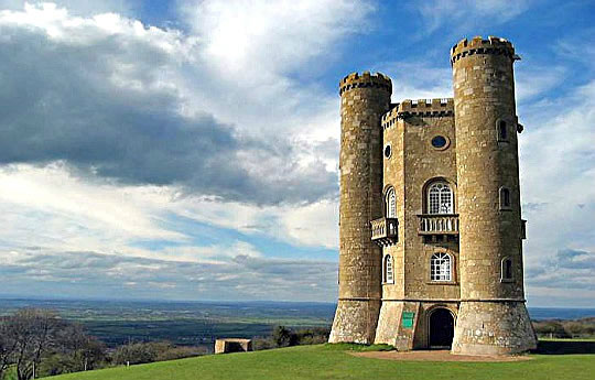
• Broadway Tower sits at the top of Broadway Hill, the second highest point in the Cotswolds. It is a beautiful view point.
• De toren is gemaakt van honey-coloured (honingkleurige) limestone en is een folly.
• Het verhaal gaat dat de vrouw van de Graaf van Coventry een kasteel wilde dat ze vanuit haar huis in Worcester kon zien. In 1798 kreeg ze het, op Broadway Hill,naar een ontwerp van de beroemde tuin- en landschapsarchitect Capability Brown.
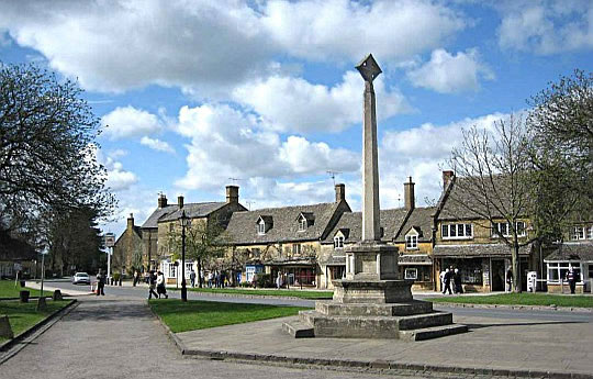
• Broadway.
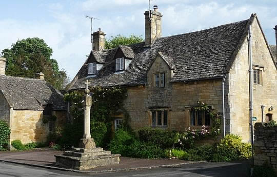
• Cottage in Stanton.
Extra dag mogelijk in:
1. Chipping Campden
The loveliest of all the ancient Cotswold Market towns, it is also the best preserved and most historically important.
Buildings of interest include:
- St James' Church is one of the best examples of a Cotswold 'wool' church and contains the largest memorial brass in the county, to William Grevel, 'the flower of the wool merchants of all England'.
- Next to the church are the gateway and onion-topped lodges of the old manor of Campden. The manor itself was destroyed during the Civil War.
- Nearby on a raised pavement stands a superb row of Almshouses built during the reign of James I in stunning symmetry.
- the Town Hall,
- the 14th century Woolstaplers Hall, where the fleeces were sold, which now.houses the town's museum;
- the magnificent Grevel House built in 1380.
- the open-sided Jacobean Market Hall, built to shelter stallholders from all weathers;
2. Bath
Het is een Unesco Werelderfgoed met zijn Georgiaanse architectuur en Romeinse baden. Zie: SouthWestEngland.html#52 en visitbath.co.uk
Eindbeoordeling:
Dit deeltraject is een echte top trail.
Beste websites:
www.cotswold-way.co.uk
........................................
www.ldwa.org.uk
Sites komen en gaan; dat valt niet bij te houden. Googel daarom ook een keer naar cotswold way en bekijk de eerste 10 (evt. 20) resultaten. Daar zitten de belangrijkste sites wel tussen.
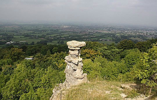
• Leckhampton Hill heeft een aantal uitzichtpunten. Hier staan we bij de Devil's Chimney.
Deze ogenschijnlijk natuurlijke pilaar op de heuvelrand is door mijnwerkers gemaakt.
• Hier was in het verleden een enorme steengroeve die in 1925 na een aantal ongelukken werd gesloten.
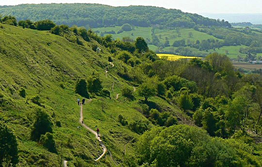
• Crickley Hill Country Park. Je kijkt naar het zuidwesten langs de westelijke rand van de 'Cotswold escarpment' (=cuestafront).
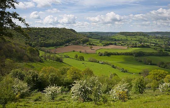
• Although just off the walk, Coaley Peak near Stroud is worth the detour since it offers some of the best views of the Severn Valley. On this photo we look to the south.
| aaaa |
The Cuesta of the Cotswolds:
• Cuesta's kunnen ontstaan, als er in een gebied een hardere laag
ligt, met erboven en eronder een pakket zachtere lagen,
waarbij het geheel zwak (enkele graden) helt.
• Erosie neemt de bovenliggende zachtere lagen weg, waardoor de zwak hellende hardere laag wordt ontbloot en hierop een lange, flauwe helling, een z.g. dip slope ontstaat.
(dip is de hellingshoek in graden met het horizontale vlak)
• Verwering en denudatie kunnen ook plaatselijk de harde laag doorbreken, waardoor de onderliggende zachtere lagen kunnen eroderen, waarbij het materiaal wordt
afgevoerd door een beek of rivier. Vervolgens breken stukken van de hardere laag af en ontstaat er een zeer steile helling, soms is ze zelfs klifachtig.
Deze zeer steile helling is de escarpment ; scarp slope (=cuestafront) (Gewoonlijk vertalen we escarpment in het Nederlands door steilrand, maar hier bij cuesta's heeft men in de geologie daar een eigen woord voor: cuestafront.)
• Het geheel vormt een asymmetrische rug, een cuesta.
Vanaf de hoogste kam loopt één helling flauw af, de andere helling is zeer steil, soms zelfs een klif.
• Anders dan bij de South Downs heeft bij de Cotswold Hills (en ook bij de North York Moors) de cuesta meer weg van een pláteau dan van een rúg.
The more massive limestones give rise to 150-metre escarpments (=cuestafronten), yet the dip slope is frequently of such a low angle that
the countryside resembles a dissected plateau(plateau doorsneden
door
rivierdalen), passing gradually on to the clay vales.
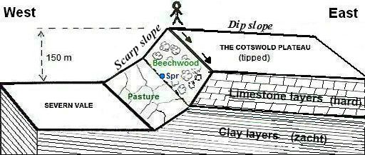
• De escarpment (cuestafront (Ned.) vormt een abrupte scheiding tussen het hooggelegen Cotswold plateau en de laag gelegen Severn Plain.
• De Cotswold Way loopt langs de westelijke rand van het plateau.
• Het hoogteverschil tussen hellingvoet en bovenrand bedraagt ca. 150 meter.
• Op de grens van kalksteen en klei ligt de 'spring-line' met natuurlijke bronnen (zie Spr) (want als het inzijgende grondwater op een slecht doorlatende kleilaag stuit, stroomt het
zijwaarts af en treedt dan uit als een bron.)
• Het bovenste (steilste) deel van het cuestafront heeft Beechwood (loofbos gedomineerd door Beuk);
het onderste deel is Pasture ('hedged fields' in gebruik als weiland).
• Dit blokdiagram overdrijft de hellingshoek van de dip slope. Ze is slechts enkele graden.
• Linksboven een stukje van de Severn Vale 150 m lager dan het pad boven op het plateau.
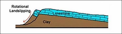
• Een
diagram van de cuesta bij Cleeve Common.
• A block has moved downslope over the underlying Clay.
• Dit blokdiagram overdrijft de hellingshoek van de dip slope. Ze is slechts enkele graden.
Zie ook voor cuesta:
engeland_southdownsway.html
| aaaa |
Limestone areas in England and Wales:
• There are three types of limestone in the British Isles, but the one that
forms
the highest upland areas is Carboniferous limestone (1) (kalksteen uit
het Carboon).
• Links van de diagonale lijn liggen de uplands (=gebieden hoger dan ongeveer 1,000 feet (± 300m) boven
zeeniveau.) De belangrijkste upland limestone landscapes in Engeland zijn: Northumberland NP , Lake District NP , Yorkshire Dales NP , North York Moors NP en Peak District NP.
• Je ziet op de kaart dat North York Moors NP wel uplands is (het ligt links van de diagonale lijn), maar geen Carboniferous limestone (1) heeft, In plaats daarvan
heeft ze de zachte, geelachtige Jurassic limestone (2).
Deze Jurassic limestone vormt een 500 km lang massief tussen Lyme Regis aan de zuidkust en Whitby aan de noordoostkust.
Ook de Cotswolds hebben die zachte, geelachtige kalksteen, maar omdat ze ten oosten van de diagonale lijn ligt, is het dus géén upland.
The map shows the three sedimentary rocks that are made from sea
creatures:
1. Carboniferous limestone
(kalksteen uit het Carboon: hard, grijs),
2. Jurassic limestone
(kalksteen uit de Jura: zacht, geelachtig) and
3. Cretaceous chalk
(krijt uit het Krijt: zacht, wit) ,
Jurassic limestone (2) and Cretaceous chalk (3) can hold water – they have tiny holes in them
and are very porous.
Carboniferous limestone (1)
Carboniferous limestone is not at all porous — although it is permeable (=doorlaatbaar) Water seeps through the joints.
The limestone is laid down in layers or 'beds' separated by bedding
planes (laagvlakken) and divided up into blocks by a series of joints (vertikale scheuren) (Joint = een vertikale scheur in een gesteente zonder dat het gesteente aan beide zijden verschoven is.)
These Joints in rock are caused by shrinkage or release of pressure as rocks above are eroded away. (Zie verder upland limestone landscapes)
A long time ago, about 350 million years ago (even before the
Dinosaurs) England was covered by a
shallow tropical sea – a bit like
where the Great Barrier Reef is forming today.
As the small animals and corals that lived in the sea died, their shells and skeletons fell to the bottom. A thick layer built up over millions of
years.
As it squashed and hardened, it eventually turned into limestone.
This Carboniferous limestone (1) is nowadays found in:
- northern
England (e.g. Yorkshire Dales, Peak district),
- Wales (e.g. Brecon Beacons) and in
- Ireland (e.g. The Burren).
| aaaa |
Belangrijke cuesta's in Engeland:
..
The map shows two long curving almost parallel cuesta's.
• The western limestone/sandstone cuesta consists of:
Cotswold Hills + Lincoln Edge + North York Moors.
(The southern end of this winding cuesta forms the
peninsula of Purbeck Hills on the English Channel.
The more massive limestones and sandstones give rise to 300-metre escarpments (=cuestafronten), yet the dip slope is frequently of such a low angle that
the countryside resembles a dissected plateau ( plateau doorsneden
door
rivierdalen), passing gradually on to the clay vales.
• The eastern chalk cuesta consists of:
Chiltern Hills + Lincolnshire Wolds + Yorkshire Wolds.
(The southern end of this winding cuesta is on the Isle of Whight.)
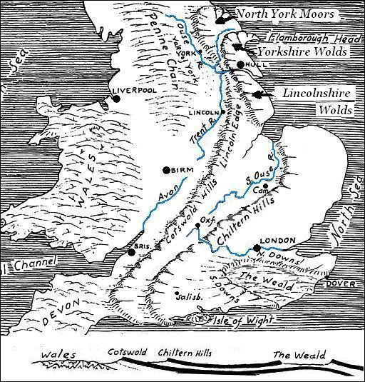
The cross section below the map shows the two relative hard layers
which form these two cuesta's.
These hard layers are separated from each other and also from the
underlying complex basement of older rocks by softer formations
of clays.
These clay beds underlie the two lowlands which form long belts just
west of the two cuesta's.
- Draining the western lowland are the rivers North Ouse, Trent and Avon.
- The eastern lowland is drained by the Southern Ouse, and the Upper . Thames. (This eastern lowland is known as the “Educational Lowland”, because it contains the cities of Oxford and Cambridge and other famous schools.)
The hard layers forming the cuesta's are limestone and sandstone beds.
The upper limestone bed which forms the Chiltern Hills is a chalk (krijt) formation , which comes out again in the South Downs and North Downs.
It also forms the “White Cliffs of Dover”
| aaaa |
Chambered Tomb (graftombe met kamer):
This term can be used to describe a wide range of stone monuments
dating from the Neolithic period that are characterised by
the use of
stone slabs (draagstenen) and/or drystone walling (stopstenen) and
capstones (dekstenen) to create a box like 'chamber' (kamer) intended
to house the bones or cremation remains of the dead.
These tombs are then covered with earth or stone and rubble to create
either
1. round barrow / long barrow
(barrow = aarden grafheuvel), or
2. round cairn / long cairn
(cairn = stenen grafheuvel).
These cairns are most commonly found in upland or stone-rich areas
and
there are identifiable regional styles.
The simplest form of the monument is the 'portal tomb' or 'dolmen' and consists of
-
a pair of upright side slabs (zijstenen) (the portals) (draagstenen) with
-
a smaller stone to the rear (sluitsteen),
-
supporting a large capstone (deksteen), and
-
a further upright slab of variable height at the front of the monument
creating a blocking door between the portals - although this stone is
often missing from surviving tombs.
The monuments can become more complex with the addition of further
large stones.
When a low narrow stone lined passage leading to the chamber is added
this creates a 'passage grave' (ganggraf). They are commonly covered by round
mounds.
In 'gallery graves' the passage is often wider, taller and longer and is
more likely to have a rectangular or trapezoidal covering
mound (heuvel).
In both cases there may be additional side chambers which give these monuments the name of 'transepted' or 'cruciform' graves.
Not all of these chambers were necessarily used for burials and in some
cases it seems that the chambers were kept accessible for long periods
of time for fresh burials and that previously deposited bones were often removed, perhaps for some kind of ritual activity, before being
redeposited in the tomb.
... Long Barrow = Langgraf ( letterlijk: Langwerpige, aarden grafheuvel) Naast . long barrow .heb je ook nog . round barrow. (ronde aarden grafheuvel) ... |
...Evenzo heb je: round cairn. en long cairn (cairn= stenen grafheuvel) Naast . long barrow .heb je ook nog . round barrow. (ronde aarden grafheuvel) ... |
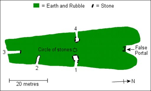
• Plattegrond van Bela Knap
• Zie ook : www.youtube.com
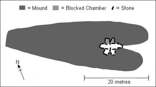
• Plattegrond van Hetty Pegler's Tump Chambered Long Barrow.
| aaaa |
Van dag tot dag bij de Cotswold Way:
Spend your first nights accommodation in Chipping Campden, a famously
quaint
ancient town featuring all the finest attributes of the Cotswolds,
from
beautiful honey coloured stone buildings to atmospheric narrow
streets
and
pleasant farmland views.
This is a fitting introduction to the
beautiful
Cotswold Way that lies
ahead.
1. Chipping Campden ― Stanton ...16½ km
- Walking out of the village we head for Dover's Hill and then Mile Drive, a narrow channel of grass that leads you to the elegant Broadway Tower. dating from 1798.
- Dropping down we reach the touristy town of Broadway.
-
This beautiful village
is well complemented by Cotswold stone and thatched roofs.
- The 12th century St. Eadburgh's Church, part of the old monastery, is well worth
viewing half a mile from the village.
- The trail now undulates over pretty Cotswold farmland and into the attractive village of Stanton.
2. Stanton ― Cleeve Hill ....21½ km
- There is much to see on this section as you pass Stanway House and continue onto Winchcombe, the ancient capital of Mercia and nearby Sudeley Castle, dating back to the 12th century.
- The trail ascends to a Neolithic long barrow Belas Knap , and onto the highest point of the Cotswolds; Cleeve Hill (317 m).
Alleen de allerbelangrijkste uitzichtspunten staan in deze kaart !
3. Cleeve Hill ― Leckhampton Hill
...16½km
- Enjoy the views over Cheltenham and on a clear day as far as the Black Mountains in Wales,
-
passing through Bill Smylie’s butterfly reserve before eventually
-
descending to Dowdewell reservoir(=stuwmeer) then
-
past Seven Springs - for
some the source of the River Thames - and
-
follow the escarpment(=cuestafront) onto
Leckhampton Hill.
4. Leckhampton Hill ― Painswick
...23 km
- More excellent views follow into Crickley Hill Country Park before
-
heading through woods and onto Birdlip.
-
The route passes close to the Roman Villa at Witcombe, where a bathhouse and fine mosaics have been unearthed & worth a look if time permits.
- Cooper’s Hill offers fine views and is today famous for its annual “Cheese rolling” event.
- Painswick, a small, ancient Cotswold market town with streets dating back to the 13th century. The local stone is light grey giving the ancient town a different feel for a normal Cotswold town.
5. Painswick ― Dursley ........24 km
- More fantastic views to enjoy today, especially the panorama from Haresfield Beacon over the Severn valley.
-
The walk is quite hilly but rewards
you with fine
vistas and historic sites, including a Neolithic long barrow Hetty Pegler's Tump , and an
Iron Age hillfort..(= hillfort; walburcht).
-
More woodland and magnificent views at Coaley Peak and Cam Long Down before reaching Dursley, an ancient town once famous for its wool and cloth.
- Cam Long Down is een geïsoleerde, erosiebestendige
heuvel.
Het
is een 'outlier' , een 'getuigeheuvel', d.w.z. een heuvel die
getuigt van de vroegere ligging van de cuesta en van de latere terugschrijding.
(Ook bij de Cleveland Way zagen we zo'n getuigeheuvel, namelijk Roseberry
Topping).
| aaaa |
SNP Natuurreizen heeft in Groot-Brittanië ook wandelreizen:
Hun reizen met een zwaarte van 1 of 2 zwarte cirkeltjes komen het beste overeen met mijn wandelingen.
Je maakt dan niet te veel hoogtemeters en wandeluren per dag.
Zie: www.snp.nl/reizen/
| aaaa |
Wandelgids: The Cotswold Way Strookkaart:
Harvey strip maps (strookkaarten) zijn de beste
kaarten. Te bestellen bij: Reisboekwinkel de Zwerver (webshop voor reisgidsen en landkaarten) |
..Deze wandelsite is niet-commercieel, onafhankelijk en gratis. Dat is enkel mogelijk door steun van de bezoekers. Uiteraard kun je ook doneren door overschrijving op mijn |
Reactie van Barbe Luc: Ik vond heel wat interessante informatie over wandelen in Engeland op je site - fijn werk ! - en heb nog één vraagje. In sommige boeken wordt de Cotswolds Way aangegeven van noord naar
zuid, in andere van zuid naar noord....., Ik zag ook op je site dat je maar een deel van het traject doet, zijn die laatste kilometers naar Bath dan echt veel minder mooi? Dank en fijn weekend nog Barbe Luc. Beste Barbe Luc, Mijn werkwijze is als volgt: Stap 1: zoek m.b.v. boeken en websites het mooiste deeltraject: Stap 2: Bepaal de wandelrichting: Groet, |
Weet je aanvullingen en verbeteringen van deze tekst?
Graag een e-mail naar:
![]()
![]() ...
... ![]() ...
... ![]()
LAATST BIJGEWERKT : 7-1-2019