...
.........NORTH. WEST. ENGLAND
| .BRITAIN'S FAVOURITE WALKS TOP 100―NORTH WEST ENGLAND |
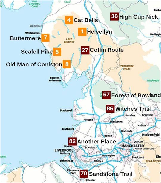
• 4 betekent: de wandeling eindigde op de 4de plaats in Britain's Favourite Walk...
• Klik je op dit nummer 4 in de kaart, dan word je doorverbonden met kader 4 hieronder.
• Alle wandelingen uit de Top 10 hebben een oranje nummer gekregen.
(Hier zie je hoe uniek het Lake District is met maar liefst 5 wandelingen in de Top 10.)
• Lichtbruin = National Park
• Lichtgroen = AONB (Area of Outstanding Natural Beauty) (the next step down from a National Park).
• De North Pennines AONB (in lichtgroen) zit alleen met het westelijke deel in de regio North West England. In de bovenstaande kaart zie je daar nummer 30 High Cup Nick.
Het Yorkshire Dales National Park daaronder in lichtbruin behoort er niet toe. Dat zit in de regio Yorkshire & The Humber.
| aaaa |
Het unieke Lake District heeft maar liefst 5 wandelingen in de Top 10.
Zie de kaart hierboven. Het is dan ook een fantastisch gebied voor een wandelvakantie. Alleen het weer kan wat tegen zitten.
The Lake District - a glaciated upland:
• The Lake District is England's highest upland, with mountains rising to almost 1000 m (highest mountain Scafell Pike = 978 m).
(upland = all land above the upper limit of enclosured (omheind) farmland.
Dit is grofweg het gebied hoger dan 1,000 feet (ongeveer 300 m).
• It is also the countries best example of a glaciated upland, with much evidence of a variety of glacial features including ribbon lakes (langgerekte meren) for which the area is famous.
As with all of our mountain regions, the Lake district used to be much, much higher than it is now, but it has been weathered and eroded by many forces, and especially by glaciers.
During the Ice Age, glaciers spread out in all directions from the highest part of the Lake District and eroded a trail of features including:
- corries (=karen) met tarns (=kaarmeertjes)
- arêtes (=graten)
- pyramidal peaks (=pyramidale pieken),
- U-shaped valleys (=dalen met U-vormig dwarsprofiel), met daarin:
- ribbon lakes (=langgerekte meren)
(most famous of these lakes being Lake Windermere (longest lake in Engl.)
Zie ook de volgende uitgebreide introducties:
glaciated upland landscapes en uplands
| aaaa |
1
1. Helvellyn (950 m)
(via Striding Edge)...Lake District
5-6 uur .. halfzwaar/zwaar
A thrilling mountain route. Helvellyn’s ridges are exciting, only a little
bit scary, but great fun.
Helvellyn is so much more than England’s third highest mountain, and
it was no surprise when this route was voted Britain’s Favourite Walk
in a 2017 ITV poll.
An ascent of this 950m peak via the narrow ridge (= graat) of Striding Edge is one of Britain’s most iconic mountain challenges,
mixing hill walking with scrambling on a spectacular route that requires the use of hands in a few places – and a good head for heights!
The classic way to walk Helvellyn is from the village of Glenridding, first climbing steeply over Birkhouse Moor with wonderful views down the Ullswater valley, then tackling the Grade 1 scramble of Striding Edge all the way to Helvellyn’s vast summit plateau
...Scrambling (= klauteren, klimmen) |
After tucking into celebratory sandwiches and enjoying views across what feels like the entire Lake District National Park, descend from the summit via Swirral Edge – another steep rocky scramble that feels intimidating when you first tiptoe towards it.
At the low point of the Swirral Edge ridge, follow the path that leads down towards the impressive glacial bowl (=kaar) containing Red Tarn then follow the obvious path down the valley to Glenridding.
IMPORTANT: If you aren’t comfortable with heights or exposed mountain terrain, this route may not be suitable for you. There are less technical routes up Helvellyn on footpaths suitable for walkers of all ages and abilities.
Rother Wandelgids 'Noord-Engeland', Tour 58 gaat door Grisedale.
Dan is het géén Top-Tour.
Doe dat daarom niet. Ga liever via Striding Edge en Swirral Edge, zie kaartje hieronder.
In dat geval heb je een spectaculaire route die toch voor vrijwel iedereen
goed te doen is. Ze is zeer bijzonder.
Ze
werd nummer 1 in Britain's favourite
walks TOP 100.
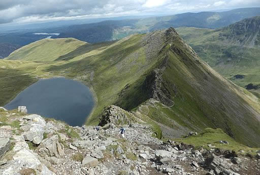
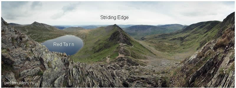
• Vanaf Helvellyn kijk je hier neer op het kaarmeer Red Tarn en rechts daarvan de graat Striding Edge.
• Helvellyn is without a doubt one of the most popular mountains in the Lake District.
Just like the best mountains around, it has many great routes to its summit, but one stands head a shoulders above the rest, and that is via Striding Edge.
Striding Edge is a spectacular knife edge arete (=graat) that offers a breathtaking
scrambling experience. From climbing across blocks, walking across a narrow crest,
and down climbing 'The Chimney', Striding Edge has it all. To the left of Hellvellyn is corrie lake Red Tarn.
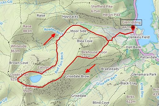
Start/Finish: Glenridding.
WB Campings:
Zie voor een overzicht anwb.nl/engeland
Wildkamperen (bivak):
Gaf mij geen problemen.
Zie voor goede introducties:
engeland_glaciated-up... en engeland_uplands
Verdere info:
www.walkingbritain.c...
......................................
https://www.youtube.c...
.........................................
http://theoutdoorguide.co...
Wandelgids: ... Tocht 58... Helvellyn ( 950 m) Kaart: OS Explorer OL5 Te bestellen bij: |
| aaaa |
4
4. Cat Bells ( 451 m)
Lake District National Park.. upland
5 km ... middelzwaar
Possibly England’s finest 'mini mountain' – perfect for everyone from families to experienced fell walkers.
This popular route up Cat Bells is one of the best walks in the Lake District – with huge views over Derwent Water, Keswick and the surrounding fells.
Cat Bells is a small hill that feels like a big mountain, with a perfectly shaped summit cone and a short rocky scramble near the top.
Scrambling (= klauteren, klimmen) |
This is a popular walk with everyone from tourists to experienced hikers – and is often used as a starter peak for parents introducing their children to hill walking.
Starting at the base Cat Bells and climbing steeply over Skelgill Bank, mountainous views quickly open up around you with the Newlands Horseshoe directly ahead and the Lake District’s shapely North-Western Fells to your right.
After bagging Cat Bells’ summit you continue onwards before dropping down towards beautiful Derwent Water at Hause Gate, then following an easy but spectacular footpath back to your start point.
De rout is slechts kort en middelzwaar (zie kaartje en hoogteprofiel).
Je blijft overal ten westen van het Derwent Water.
Tour 54 in Noord-Engeland (Rother Wandelgids) is veel langer en
zwaarder dan die van het kaartje hier onderaan.
Je komt dan veel verder zuidwaarts dan het Derwent Water tot zelfs
bij Seatoller.
• Cat Bells gezien vanaf Derwent Water.
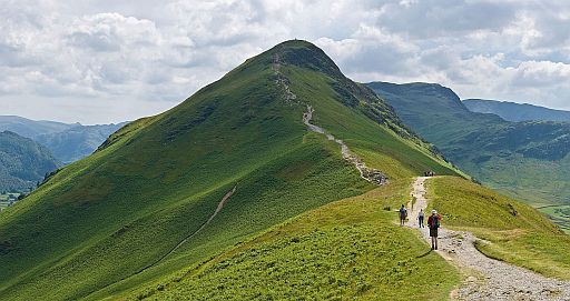
• The classic route is over the bumps
of the North Ridge.
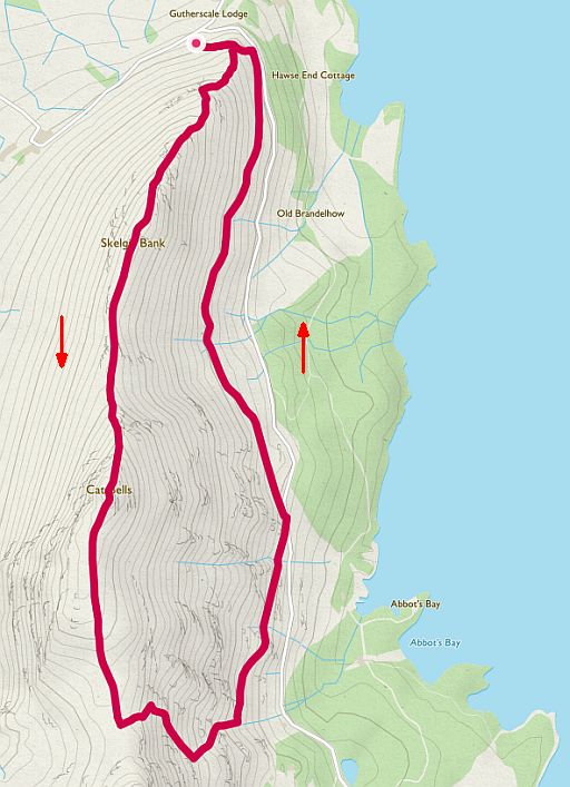
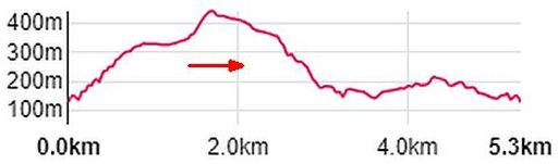
Totale stijging = 570 m
Start / finish: bushalte resp. parkeerplaats van Catbells
ANWB Campings:
Zie voor een overzicht anwb.nl/engeland
Wildkamperen (bivak):
Gaf mij geen problemen.
Zie voor goede introducties:
engeland_glaciated-up... en engeland_uplands
Verdere info:
https://www.youtube....
.........................................
https://osmaps.ordnance...
Wandelgids: ... Tocht 54 Kaart: OS Explorer OL4 Te bestellen bij: |
| aaaa |
5
5. Scafell Pike (978 m)
Lake District N.P........mountain
11 ½ km........ zwaar
England’s highest mountain, and possibly also its best.
This circular hike explores it from multiple angles, giving you chance
to
really get
to know the peak.
IMPORTANT: Scafell Pike is a big, fierce mountain where walkers
often face strong winds, heavy rain and low visibility.
Plan your route carefully and always carry suitable hill walking gear.
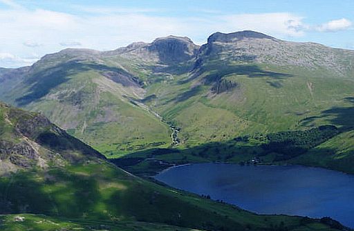
This circular walk up Scafell Pike – England’s highest mountain – starts and finishes in the remote Wasdale valley, on the shore of England’s deepest lake.
At 978m Scafell Pike marks the highest point in England, so reaching
the summit is a tough challenge for any hill walker.
This walk starts near the Wasdale Head pub and follows Lingmell Beck towards Sty Head, a famous Lakeland mountain pass between the
iconic
peak of Great Gable and the rocky bulk of the Scafell range.
From Sty Head you follow the thrilling Corridor Route that clings to
the mountainside beneath Great End, before turning left at Lingmell Col for the final push to the top.
You’re unlikely to be alone as you cross the boulder fields surrounding
the summit (this is a very popular place!) but you’ll be rewarded with
views stretching across the surrounding fells and valleys – and all the
way out to
the Irish Sea.
The descent follows the path through Hollow Stones – popular with anyone attempting the National Three Peaks Challenge – back to your start point in the Wasdale valley.
Noord-Engeland (Rother Wandelgids) loopt de route tegen de wijzers van de klok in en heeft ook een wat langere lus. Daardoor duurt haar Top-Tour wat langer en is ze nog wat zwaarder.
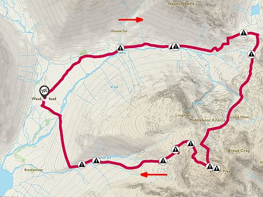
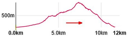
Totale stijging = 1170 m
Start / finish: Wasdale Head.
ANWB Campings:
Zie voor een overzicht anwb.nl/engeland
Wildkamperen (bivak):
Gaf mij geen problemen.
Zie voor goede introducties:
engeland_glaciated-up... en engeland_uplands
Verdere info:
https://www.youtube.com..
............................................
https://osmaps.ordnances...
Wandelgids: ... Tocht 50 .... Scafell Pike 4 (978m) Kaart: OS Explorer OL6 Te bestellen bij: |
| aaaa |
7
7. Buttermere ....Round-the-lake walk
Lake District N. P.........7 km.........licht
With the iconic view down the lake to Fleetwith Pike and miles of stunning shoreline to explore, Buttermere is a wonderful walk for all ages and abilities.
This lakeside walk does a full lap of Buttermere, passing through rocky tunnels and woodlands surrounded by some of England’s finest mountain scenery.
The walk has an adventurous feel from start to finish.
You can grapple with rock, lose yourself in beautiful woodlands and
skim stones on the lake.
All the while you’ll be surrounded by towering mountains, – from
Fleetwith Pike and Haystacks to the High Stile range that looms large
above Buttermere’s western shore.
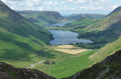
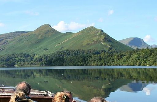
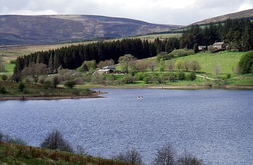
• Buttermere en daarachter Crummock Water gezien vanaf Haystacks.
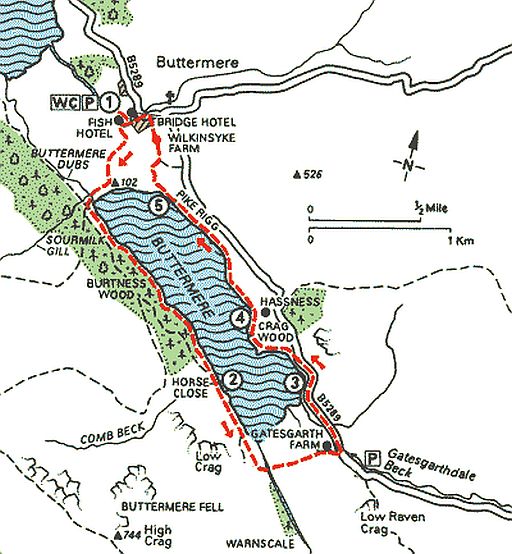
Start / finish: Buttermere.
ANWB Campings:
Zie voor een overzicht anwb.nl/engeland
Wildkamperen (bivak):
Gaf mij geen problemen.
Zie voor goede introducties:
engeland_glaciated-up... en engeland_uplands
Verdere info:
www.theaa.com/walks/a...
.............................................
https://osmaps.ordnancesu...
Wandelgids: ... Tocht 53 ..... Buttermere en Rannerdale Knotts Kaart: OS Explorer OL4 Te bestellen bij: |
| aaaa |
8
8. Old Man of Coniston (803 m)
Lake District N.P. mountain
12 km ...middelzwaar/zwaar
A Lakeland classic that ticks off three fine summits in one long,
beautiful
fell walk. It’s always busy, but that’s because it’s so good!
IMPORTANT: This is a long, tough mountain where you’ll need to be
prepared for high winds, heavy rain and low visibility.
Plan your route carefully and always carry suitable hill walking gear.
This circular route in the southern Lake District visits the summits of
the Old Man of Coniston, Swirl How and Wetherlam in one fantastic
walk.
The Old Man of Coniston is the perfect peak to introduce newcomers
to hill walking, mixing rugged mountain scenery with fascinating
history
thanks to
the abandoned mine workings scattered across its
lower slopes.
You’ll also climb past the secluded mountain tarn of Low Water on
your
ascent – a great spot for a wild swim on a hot day.
But the excitement doesn’t finish at The Old Man’s massive summit
cairn – you’ll head north along a wide rolling ridge to Swirl How, then
tackle a rocky descent down the ominously named Prison Band before
climbing to the fine summit of Wetherlam.
You should have just enough energy left in your legs to descend to the
village of Coniston and its welcoming pubs. As you walk down
Wetherlam you’ll get fine views across Coniston Water, where
Donald Campbell was famously
killed while attempting to set a world
water speed record in 1967.
• Kijkend over het Coniston Water naar de Old Man of Coniston.
• Levers Water with Coniston Water in the background.
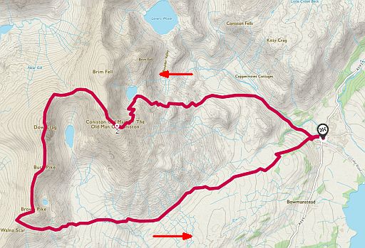
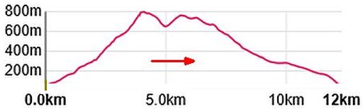
Totale stijging = 930 m
Start / finish: Coniston
ANWB Campings:
Zie voor een overzicht anwb.nl/engeland
Wildkamperen (bivak):
Gaf mij geen problemen.
Zie voor goede introducties:
engeland_glaciated-up... en engeland_uplands
Verdere info:
https://en.wikipedia.o...
.......................................
https://osmaps.ordnan...
Wandelgids: ... Tocht 43... Swirl How ( 802 m ) en Kaart: OS Explorer OL6 Te bestellen bij: |
| aaaa |
27
27. Coffin Route
(Ambleside – Grasmere)
Lake District National Park
6 ½ km .... lichte wandeling
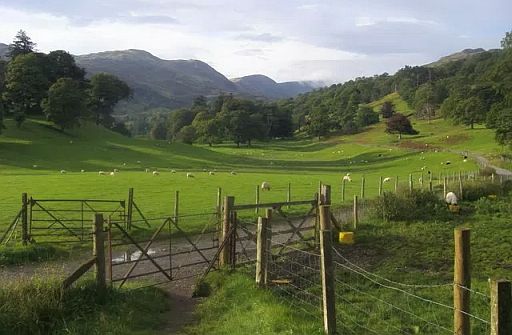
Despite its spooky name, there’s nothing to fear on this beautiful
woodland trail between two of the Lake District’s most popular
settlements. Don’t let the name scare you – the Coffin Route is a glorious woodland walk between Ambleside and Grasmere in the
Lake District National Park.
Starting in the busy Lakeland town of Ambleside this walk follows a
medieval corpse road that was once used to transport dead bodies to
their final resting place at St Oswald’s Church in Grasmere.
You’ll find no skeletons, ghosts or ghouls here today though, just a
beautiful
3-mile walk that cuts through a wooded valley and passes
the lakes of Rydal Water and Grasmere.
With the Fairfield horseshoe to the north and the ever-popular
Loughrigg Fell to the south, you’re right in the heart of the
Lake District’s finest mountain scenery, but apart from some slight
undulation this is a gentle stroll that walkers of all ages and abilities
can enjoy.
Along the way you’ll pass historic Dove Cottage – once the family home
of famous Lakeland poet William Wordsworth – en route to the idyllic
village of Grasmere with its pubs, cafes, shops and famous gingerbread.
There are plenty of buses that run along the A591 back to Ambleside,
but why not give yourself a treat and walk the route in reverse to savour
those views from the opposite direction?
Noord-Engeland (Rother Wandelgids) Tour 46 maakt hier een lus
tussen Grasmere en Rydal.
De noordelijke helft van die lus is de
'Coffin Route'.
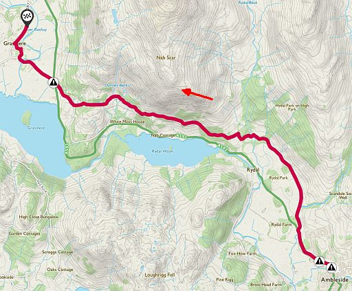
Start: Ambleside
Finish: Grasmere
Take first the bus from Grasmere to Ambleside and start walking there.
ANWB Campings:
Zie voor een overzicht anwb.nl/engeland
Wildkamperen (bivak):
Gaf mij geen problemen.
Verdere info:
https://osmaps.ordnanc...
Wandelgids: ... Tocht 46 .. Rondom Grasmere en Rydal Water Kaart: OS Explorer OL7 Te bestellen bij: |
| aaaa |
30
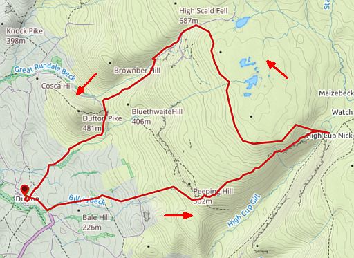
30. High Cup Nick (693 m)
....... North Pennines AONB .... upland
....... 15½ km..... middelzwaar
High Cup Nick is a place that must be seen to be believed – they don’t call it the Grand Canyon of the Pennines for nothing !
This walk explores the magnificent U-shaped glacial valley of High Cup Nick in the Northern Pennines from the picturesque village
of Dufton.
Often dubbed ‘The Grand Canyon of the Pennines’, High Cup Nick is
one of those places that has to be seen to be believed.
In stark contrast to the rounded, sweeping hills that surround it,
this spectacular gorge looks like it’s been carved out of the landscape
by a giant
ice cream scoop.
The distinctive ring of dark crags around the rim of the valley is formed
from a layer of tough grey-blue dolerite, which gives the whole place a dramatic and almost otherworldly feel.
The best viewpoint is found at the head of the canyon, above the
jumble of rocks that spill down to the valley floor.
If you’re feeling adventurous you can scramble down the rocks into
the valley, or follow this route past High Scald Fell and Dufton Pike back to your start point.
Noord-Engeland (Rother Wandelgids) Top-Tour 23 maakt hier een lus iets verder naar het zuiden. Deze loopt rondom de High Cup Gill. Zie kaartje hieronder.
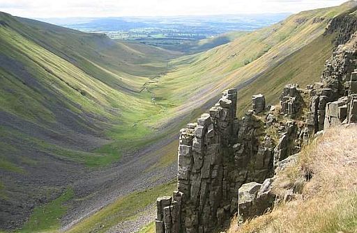
• Looking down from the head of High Cup Nick. (head = boveneinde van een dal)
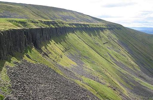
• The southern escarpment (= steilrand) of High Cup Nick.
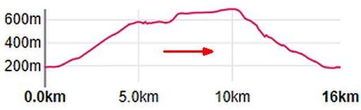
Totale stijging = 660 m
Hier heb je upland (=land lying above the limit of enclosed farmland)
Start / finish: Dufton.
ANWB Campings:
Zie voor een overzicht anwb.nl/engeland
Wildkamperen (bivak):
Gaf mij geen problemen.
Zie voor goede introducties:
engeland_glaciated-up... en engeland_uplands
Verdere info:
www.visitcumbria.co...
......................................
https://osmaps.ordnan...
Wandelgids: ... Tocht 23 .. High Cup Nick (574 m) Kaart: OS Explorer OL19 Te bestellen bij: |
| aaaa |
67
67. Forest of Bowland
(around Stocks Reservoir)
Forest of Bowla...... 11 km . licht
This Area of Outstanding Natural Beauty (AONB) covers 312 square
miles
of moorland, lowland, rivers and villages.
A favourite walk here takes in the trail around Stocks Reservoir which
passes through the Gisburn Forest.
Forest of Bowland — An example in the southern Pennines where Carboniferous sandstones and grits form high exposed moorland areas. (Carboniferous— Period of time between 290 and 354 million years ago) |
• Stocks Reservoir.
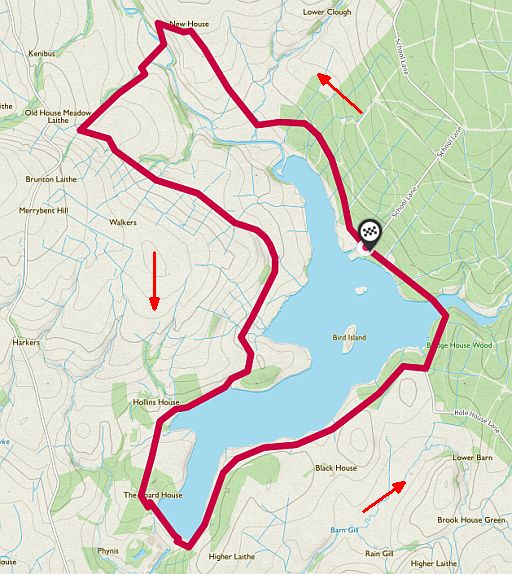
Start / finish: Stocks Reservoir Car Park.
ANWB Campings:
Zie voor een overzicht anwb.nl/engeland
Wildkamperen (bivak):
Gaf mij geen problemen.
Verdere info:
https://where2walk.co.uk...
..............................................
https://osmaps.ordnancesu...
Wandelgids: Kaart: OS Explorer OL41 Te bestellen bij: |
| aaaa |
70
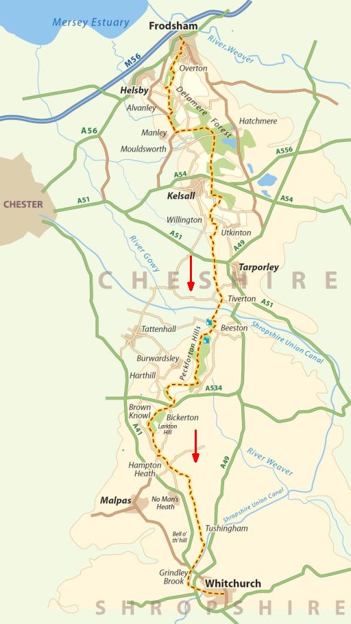
70. Sandstone Trail.....Cheshire..
54½ km ...... middelzwaar
Moderate. Some easy bits, but also steeper slopes in places.
Most of this is on roads and wider trails.
This route stretches for 54 ½ km and you can take a number of routes
varying in difficulty and length but all offer spectacular views.
Dont miss Delamere forest , the largest woodland in Cheshire, Beeston Castle and the historic market towns of Frodsham and Whitchurch. Forest.
Cheshire Plain — Lowlands area of England, on the border with North Wales. |
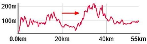
Totale stijging = 1290 m
Start: Frodsham
Finish: Whitchurch
ANWB Campings:
Zie voor een overzicht anwb.nl/engeland
Wildkamperen (bivak):
Gaf mij geen problemen.
Verdere info:
https://en.wikipedia.or...
..........................................
https://osmaps.ordnances...
Wandelgids: Kaart: OS Landranger 257, 267 Te bestellen bij: |
| aaaa |
82
82. Another Place, Art Trail,
Crosby Beach.... Liverpool
8 km ........ lichte wandeling
‘Another Place’ consists of 100 cast iron life-size figures by British
sculptor Sir Antony Gormley spread out along three kilometres of
the
foreshore, stretching almost one kilometre out to sea.
( foreshore = vooroever ; het gebied tussen hoog- en laagwater.) Each figure is 189 cm tall and weighs around 650 kg.
In common with most of Gormley's work, the figures are cast replicas
of his own body.
As the tides ebb and flow, the figures are, respectively, revealed and
submerged by the sea.
The starting point for this walk is the nearby Waterloo station.
Your exact route will change depending on the tide.
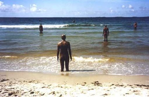
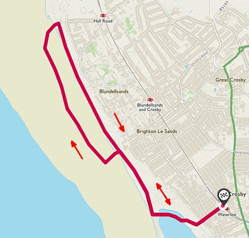
Start / finish: Waterloo Station
ANWB Campings:
Zie voor een overzicht anwb.nl/engeland
Wildkamperen (bivak):
Gaf mij geen problemen.
Verdere info:
https://en.wikipedia.org/...
.............................................
https://osmaps.ordnancesu...
Wandelgids: Kaart: OS Landranger 275 Te bestellen bij: |
| aaaa |
86
86. Walking with Witches Trail
.Forest of Bowland AONB
11 km .....lichte wandeling
The picturesque villages nestled in the shadows of the infamous Pendle Hill have a dark history of intrigue and witchcraft.
This route starts at the Pendle Heritage Centre and loops around
those
villages that were at the centre of the most infamous witch
trial in
British history.
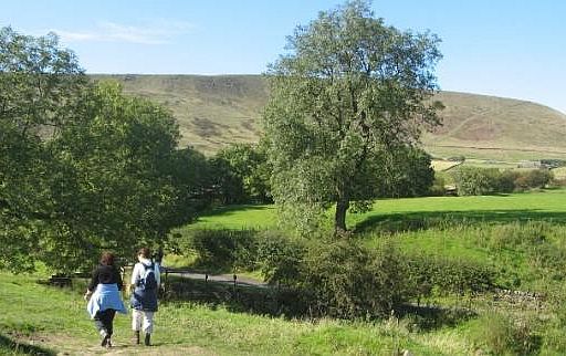
• Walking up Pendle Hill.
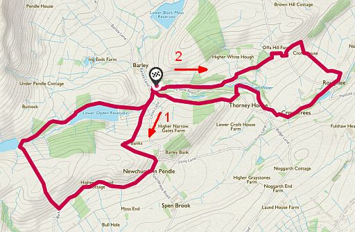
• First western loop ( 6 km), than eastern loop ( 5 km).
Start / finish: Pendle Heritage Centre
ANWB Campings:
Zie voor een overzicht anwb.nl/engeland
Wildkamperen (bivak):
Gaf mij geen problemen.
Verdere info:
www.visitlancashire.com/...
............................................
www.youtube.com/watch...
...........................................
https://osmaps.ordnance..
Wandelgids: Kaart: OS Landranger OL21, OL41 Te bestellen bij: |
| aaaa |
..Deze wandelsite is niet-commercieel, onafhankelijk en gratis. Dat is enkel mogelijk door steun van de bezoekers. Uiteraard kun je ook doneren door overschrijving op mijn |
Weet je aanvullingen en verbeteringen van deze tekst?
Graag een e-mail naar:
![]()
..![]() ....
.... ![]() ...
...![]()
LAATST BIJGEWERKT : 7-1-2019