.
... REBILD .BAKKER .RUTEN .... 11 km.....
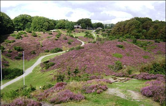
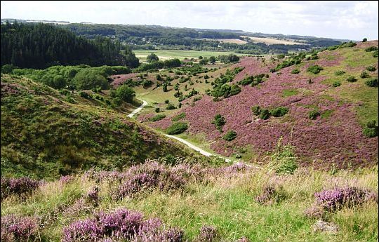
Rebild Bakker:
Rebild Bakker was vroeger gemeenschappelijke weidegrond.
In 1912 verwierf een groep Deens-Amerikanen het land en schonk het aan
de Deense staat.
Er waren drie voorwaarden:
1. het gebied moest in natuurlijke staat blijven,
2. het moest voor iedereen toegankelijk zijn en
3. de Deens-Amerikanen zouden op Amerikaanse feestdagen hier evenementen moeten kunnen houden.
Het gebied kreeg de naam 'Rebild National Park' en er wordt hier elk jaar
de Amerikaanse 'Independence Day' op 4 juli gevierd.
Er zijn in dit heuvelachtige terrein enkele wandelroutes, een mountainbike route
en een ruiterpad uitgezet.
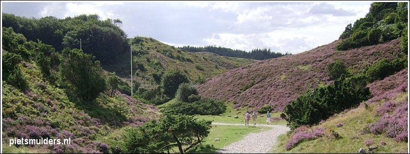
Het gebied bestaat uit een mozaïek van heide en oud, misvormd beukenbos. De heide wordt begraasd met schapen.
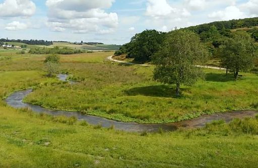
Aan de voet van de hellingen ontspringen bronnen met een zeldzame fauna.
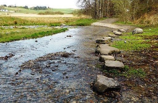
We passeren er twee op de wandeling: Kovadsbæk (28) en Ravnkilde (29).
|
|
| .. . REBILD. BAKKER.. RUTEN. . 11 km . |
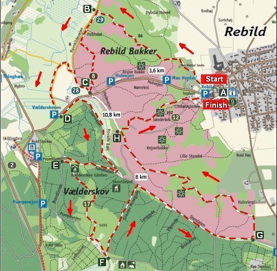
• De rode streepjeslijn is de wandelroute Rebild Bakker Ruten.
• Loop deze rondwandeling tegen de klok in (dus ABC...etc.)
Je hebt dan het prachtige uitzicht op het rivierdal van voren als je van A naar B loopt.
Video's:
www.youtube.com/watch?v=IRz
www.youtube.com/watch?v=FV (opname met een drone)
Lengte:11 km
De gehele witte route is 11 km (zie bovenstaande kaart).
De noordelijke lus naar Ravnkilde Bakker en Gravlevdalen is 3 ½ km.
De zuidelijke naar Rebild Bakker en Troldeskoven is 8 km.
Zwaarte: licht.
Het hoogste punt van de route ligt op ongeveer 100 m boven zeeniveau en
het laagste op ongeveer 10 m.
De wandeling is een rollercoaster tussen die twee waarden.
(Een keer of drie loop je op en neer daartussen.)
Toch is het maar een lichte wandeling.
Je wordt goed beloond met vele mooie uitzichten.
Routemarkering:
De route is zeer goed gemarkeerd in het terrein.
Beste periode: Juni, juli en augustus.
Wil je de Struikhei in volle bloei zien, dan moet je
ongeveer rond de
laatste
week van
augustus hier zijn.
.Klimaat Ålborg |
apr |
mei |
jun |
jul |
aug |
sep |
okt |
.Gemiddelde maximumtemp. °C |
10
|
15
|
19
|
20
|
20
|
16
|
12
|
.Maandsom neerslag (mm) |
36
|
44
|
51
|
63
|
57
|
65
|
66
|
| ( Gem. maximumtemp. De Bilt ) | 14 | 18 | 20 | 23 | 23 | 19 | 15 |
Begin- en eindpunt:
Tourist-Infocenter Rebild Porten
Rebildvej 25A, DK-9520 Skørping.
Bezoek vooraf dit informatiecentrum.
Bij aanvang van de wandeling steek je bij dit infocentrum noordwaarts de
hoofdweg over en
daar vind je het eerste markeringsteken.
Loop vervolgens ABC ..... etc.
Horeca:
- Bij de parkeerplaats in Rebild.
- Rold Storkro,
- Lincoln Blokhus.
ANWB Campings:
Zie voor een overzicht anwbcamping.nl/denemarken
Wildkamperen:
Dit geeft geen problemen.
Deense weerdienst (Engelstalig):
www.dmi.dk/lokation/show/DK/2613
Eindbeoordeling:
Een prachtige wandeling.
Beste websites:
www.rebildporten.com/rebild/pla
https://naturstyrelsen.dk/media/2
https://eng.naturstyrelsen.dk/exp
(geeft uitgebreide informatie over de geschiedenis van Rold Skov)
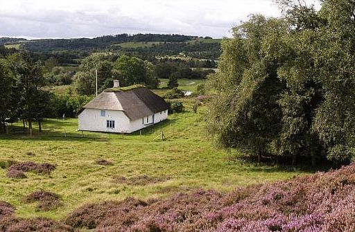
Ravnkilde (29) (kilde = bron)
|
Lars Kjærs Hus (8) |
Kovadsbæk (28) (bæk = beek)
|
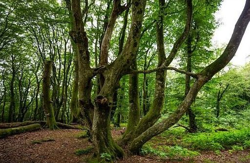
Troldeskoven (17) (Het Trollenbos) Dit is een oud beukenbos met misvormde, meerstammige beuken van
wel
300 jaar oud.
|
Stendalen |

De onechte heuvels bij Rebild:
Het Deense woord bakker vertaal je letterlijk door heuvels.
Het gebied ziet er wel heuvelachtig uit, maar er zijn hier géén echte heuvels !
Het zijn diepe smeltwaterkloven die
vlak na de ijstijd gevormd werden in de
grenszone tussen het rivierdal en het plateau.
During and following the end of the Ice Age, multiple deep erosion valleys were
carved in the border zone between the valley and the plateau, and these form
Rebild Bakker.
The ice left a wavy landscape with large quantities of melting ice.
As the land was not yet covered in vegetation, the water easily dug new channels as it flowed towards the river valley already formed.
Therefore, from the west, Rebild Bakker is merely hills with
valleys such as
Store and Lille Stendal, Hørgdalen, Pallisdal etc. cut into the high land.
During the melt after the Ice Age, for a period a large lump of ice formed a cork
in the Gravlevdalen valley with the effect that the material washed down material
was deposited in the lake along the edge of the ice.
As the ice melted, new layers were deposited and these are now seen as
horizontal terraces in several levels at the foot of Rebild Bakker.
The house of the poacher, Lars Kjær, is on one of these terraces.
Limestone: (kalksteen)
The entirety of Rold Skov is situated on limestone (kalksteen) and chalk (krijt)
and in the slopes of Gravlev Ådal there are chalky outcrops (dagzomen)
(daar treedt krijt aan de oppervlakte) .
Traces of limestone mining are visible in the surface of the limestone quarry(= kalksteengroeve) Skillingbro Kalkgrav (2) where you can go hunting for fossils
or
visit the limestone mine of Thingbæk Kalkmine (1) whose tunnels house a
sculptural museum.
The forest of springs: (Bronnenbos)
Nowhere else in Denmark will you find this many springs.
Springs as big as the ones you find in the woodlands of Rold Skov.
Rainwater accumulates under the forest in fissures (spleten) in the limestone,
and
where the erosion of millennia has exposed the limestone of the valleys,
water will spring ( te voorschijn komen in de vorm van bronnen) at the foot of the hills some 50 years later.
The water is cool, 7-8° C all year round.
It has maintained its temperature since the end of the ice age more than
12,000 years ago.
The stabile micro-climate of the springs has provided for an interesting flora;
especially, populations of small animals are particularly abundant.
The springs are home to several hundred species of small mosquitoes,
rare caddis flies (Kokerjuffers), mayflies (Eendagsvliegen) , flatworms, etc.
Several species have survived in the springs since the end of the ice age,
completely unaffected by numerous changes in the climate.
Gravlev Ådal has no less than seven larger springs, of which five are passed
on the walk around the lake Gravlev Sø.
Near the springs and along the stream (waterloop) Lindenborg Å, you may
spot otters,
dippers (Waterspreeuwen), kingfishers (IJsvogels) and grey wagtails
(Grote gele kwikstaarten).
Trout (Forellen) use the gravel bottom of the spring brooks as spawning grounds
(paaigronden).

Nature
The Rebild farmers used the moorland 'hills' (heidehellingen) as
common grazing area ( gemeenschappelijke weidegrond )
for cattle, horses and sheep as late as 1912,
when the area became
designated
national park.
They also cut the heather for winter feed crops, fuel, thatching, bedding, etc.
In old photos, you can see how well the grazing and the cutting
kept
trees and bushes off the 'hills'.
This has been preserved for nearly 100 years
by preservation and conservation.
The road at the bottom of the valley Stendalen forms a clear boundary
between the heather- and juniper (Jeneverbes)-covered northerly 'hills' and
the southerly
wooded 'hill'.
Originally, this was home to old beeches, like Troldeskoven (17) (the Troll forest),
but today most of its growth is conifers.
The conservation of Rebild Bakker is an eternal struggle with the trees.
If the area was left to its own device, the heather-covered 'hills would
quickly turn into woodland. The aspen (Ratelpopulier) would be the first
arrival and
followed closely by beeches.
In recent years, sections of beech forest have been cut down to allow
the ''hills' to become visible again.
However, animals still make up the most important conservation tool.
Sheep graze the slopes, preserving the characteristic population of heather
by eating grasses and saplings (kleine bomen).
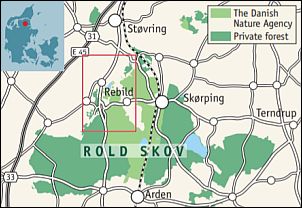
The history and geology:
Rebild Bakker are actually not hills (heuvels), at all.
Rebild is located on a plateau 60 metres above the level of the present valley of the stream Lindenborg Å and when the ice age ended 12,000 years ago, the melt water
and rain water cut the deep meltwater ravines visible today.
The Rebild area was settled early, as the sandy soil was easily cultivated
by the primitive tools of ancient times.
The sandy soil was quickly depleted, and heather took over and
turned the 'hills'
into moorland (heide).
The steep slopes could not be cultivated but were used as common grazing areas (gemeenschappelijke weidegrond) (village commons).
Previously, there were many more dwellings in Rebild Bakker; however, these days,
there is only the House of Lars Kjær (8), which has been turned into a museum
for the renowned poacher and his wife, Marie, who was a fortune-teller.
In the forested parts of the 'hills', you can see the twisted (gedraaide) and
multistemmed
beeches characteristic of the deciduous woodland of the old
Rold Skov.
Their appearance results from being repeatedly chewed down or cut down
for fire wood. The fire wood was used for charcoal, amongst others.
Exhibitions on the history of the area may be found at Museum Rebild (9).
Rebild National Park:
Rebild National Park Society, or Rebildselskabet, was founded in 1912.
A circle of Danish emigrants living in the USA, fronted by Max Henius,
collected donations which financed the acquisition of approximately
80 hectares of land in Rebild Bakker.
At the first Rebild Celebration in 1912, the land was granted to
King Christian X
on behalf of the Danish people on the following terms (voorwaarden):
-The National Park shall be open to the public and access shall be free.
- The National Park shall remain a natural scenery (natuurlandschap).
- Rebild Celebrations shall be held on 4th of July, the
American
Independence Day, and the National Park shall be available for other
activities celebrating the Danish-American friendship association.
Ever since then, the 4th of July Rebild Celebrations have attracted many
participants who, through speeches, song and entertainment, have celebrated
the friendship of the two nations.
The location of the Celebrations is the natural amphitheatre Gryden (12).
Exhibits in the Lincoln Log Cabin (9) tell more of the story and one of the
walking trails leads past the bust of Max Henius.
Nature restoration in the valley of Lindenborg Ådal:
Many of the beautiful natural features (natuurtypen) of the valley have been
undergoing significant changes since the mid-1800s.
Streams (waterlopen) were straightened, lakes, marshes and springs were drained,
fish farms were established, and the land was put into agricultural rotation.
However, at the end of the 1990s, the area was restored in order to preserve
biological diversity and the characteristic open landscape of the valley.
Fish farming has been replaced by winding spring brooklets (bronbeken);
the lake Gravlev Sø dominates the landscape once more and Lindenborg Å
winds its way across the valley.
The overgrowth (overwoekering) of willow, birch and reeds has been stopped
and
replaced by cattle grazing in the meadows.
Wandelgidsje:
Te bestellen bij: |
|
 |
... Deze wandelsite is niet-commercieel, onafhankelijk en gratis. ... • Heb je zelf nog geen PayPal-rekening, dan kun je toch via PayPal ...... vanaf je creditcard geld overmaken. ....Uiteraard kun je ook doneren door overschrijving op mijn |
Weet je aanvullingen en verbeteringen van deze tekst?
Graag een e-mail naar:
![]()
.....................................
![]() .....
.....
![]() . ..
. ..
![]()
LAATST BIJGEWERKT : 23-1-2020