| |
.
....... MOOISTE. KUSTWANDELINGEN
........................ WALES
................. ( weekendwandelingen )
..... Snel naar:
.....( klik op rode naam in kaart)
• Lichtbruin = National Park.
.. Wales heeft er drie: Pembrokeshire Coast National Park, Snowdonia National Park en
.. Brecon Beacons National Park.
• Lichtgroen = AONB (Area of Outstanding Natural Beauty)
......................................... ( the next step down from a National Park).
......................................... Dat zijn er een groter aantal met o.a. :
......................................... The Gower AONB . en
. Anglesey AONB. |
In Britain's Favourite Walks Top 100 stonden alle drie de kustpaden
uit Wales behoorlijk hoog, namelijk:
...... 16. Pembrokeshire Coast Path,
...... 28. The Gower,
...... 32. Anglesey Coastal Path.
...........
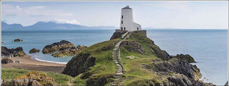
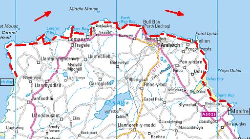
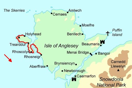
Anglesey
Anglesey Coastal Path
Church Bay - Moelfre ......... 47 km / 2-3 dagen
Topper onder de kustwandelingen:
Zie: Top 10 UK coastal walks.
Terrein:
Mainly low, grass-topped cliffs and rocky foreshore,
plus sandy bays and a few lanes.
Introductie:
• Anglesey's low, flat interior is a curiously empty land of rolling green
.. fields
and whitewashed buildings that feels more akin to Cornwall
.. than
Wales.
• For the walker, its the 201 km of coastline that sets the island apart,
.. varying from a low shoreline of dunes and fields in the south to the
.. undulating cliff terrain, pebble coves and sandy bays along the north
.. and
east coasts.
• The northern coast forms the basis for this walk.
• Highlights include views of Holy Island, sea stacks
.. (= brandingspilaren, klippen) and caves (= brandingsgrotten) ,
.. the Cemlyn nature reserve and Point Lynas lighthouse.
• Amlwch is about halfway, and has hotels and B&Bs.
Verdere informatie:
 wales_angleseycoastalpath.html wales_angleseycoastalpath.html
.
 streetmap.co.uk streetmap.co.uk
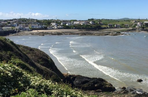
• Looking down on Cemaes Bay.
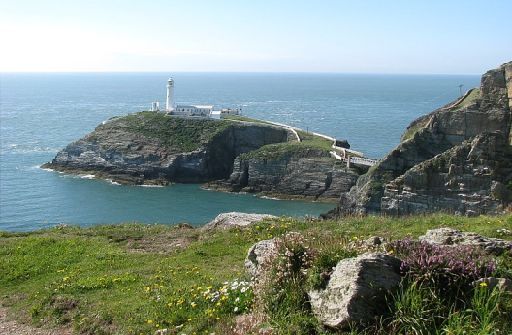
• South Stack Lighthouse
Mooi deeltrajectje van 2 of 3 dagen volgens:
www.contours.co.uk/isle-of-ang
1. Holyhead ― Trearddur ................................ 19 km
2. Trearddur ― Four mile bridge .................... 14 km
3. Four mile bridge ― Rhosneigr .................... 11 km
ANWB Campings:
Zie voor een overzicht anwb.nl/wales.
Wildkamperen:
Een nachtje bivakkeren ('s avonds de trekkerstent opzetten en 's morgens
weer
afbreken) geeft geen problemen.
Verdere info:
www.pietsmulders.nl/wales_angle
https://osmaps.ordnancesurvey.co
|
Pembrokeshire
Pembrokeshire
Broad Haven – Porthgain ........... 53 km / 3 dagen
Terrein:
Rugged and sometimes challenging cliff scenery,
although the high-level path is generally quite firm and
interspersed with pleasant sandy bays.
Introductie:
• Pembrokeshire is unique among Britain's national parks in being
.. predominantly coastal - nowhere in it are you more than 16 km from
. .the sea.
• It also boasts the only marine nature reserve in Wales and, for its size,
.. has one of the highest densities of protected environmental sites in
.. europe.
• It is a coast that combines rugged cliffs and sandy bays,
..prehistoric remains and medieval castles, and enjoys plenty of natural
..history - from the wonderful array of wild flowers to the grey seals and
..seabirds.
• It's no coincidence that this national park has a razorbill (= Alk) for its
.. symbol, although for a real close-up at the likes of puffins
.. (Papegaaiduikers), shearwaters (Pijlstormvogels) and kittiwakes
. .(Drieteenmeeuwen), it's best
to put a day aside for a boat trip to one
.. of the offshore islands where the
birds congregate.
Verdere informatie:
wales_pembrokeshirecoastpath.html
.
 streetmap.co.uk streetmap.co.uk
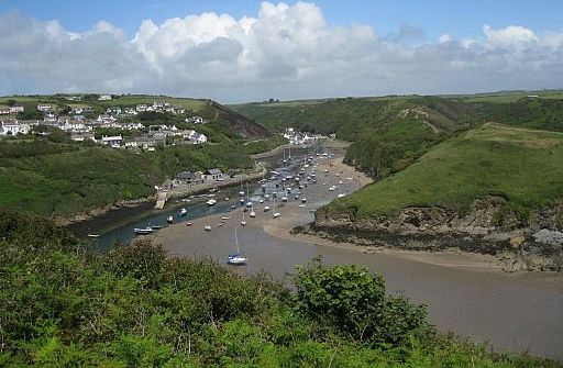 • Solva is a popular traditional village in a wooded, steep-sided inlet but new • Solva is a popular traditional village in a wooded, steep-sided inlet but new
.. development extends up onto the plateau.
.. It is one of the most sheltered (= beschutte) anchorages between Fishguard
.. and Milford Haven.
• It's possible to walk around the headlands, where there are wonderful views
.. into the harbour, both
at low and high water.
• In the 19th century, Solva had around 30 registered trading ships.
• Coastal trade has been replaced by tourism, and the harbour is now a
.. popular boating centre.
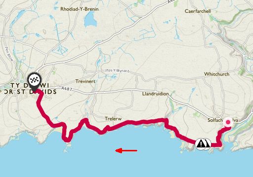
In Britain's Favourite Walks Top 100 stond een klein deeltraject
daarvan
op de 16 ste plaats. Dat is erg hoog.
Het was:
16. Solva .― St Davids,
.....Pembrokeshire Coast National Park .... 7 km ..... licht
Follow this section of the Pembrokeshire Coast Path to explore
the pastel
painted village of Solva.
Take time to explore the harbour and unspoiled coastline.
For a longer walk, head for the UK’s smallest city, St Davids.
ANWB Campings:
Zie voor een overzicht anwb.nl/wales.
Wildkamperen:
Een nachtje bivakkeren ('s avonds de trekkerstent opzetten en 's morgens
weer
afbreken) geeft geen problemen.
Verdere info:
Rother Wanderführer doet deze niet, maar heeft hier Tour 41,
die er mooi op aansluit.
https://osmaps.ordnancesurvey.co.uk/route/1672670/....
|
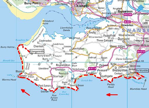
TheGower
The Gower
The Mumbles – Llangennith ......... 45 km / 2 dagen
.
Terrein:
From promenade and surfaced paths to rough cliff tracks and sandy
bays.
Introductie:
• The Gower is a small and attractive limestone peninsula that sticks
.. out
like an oversized big toe from Swansea into the sea off south
.. Wales.
• Modest in size, its enduring popularity is testimony to its mild climate,
.. sunny disposition and kilometers of golden sand.
• Its 55 km of coastline boasts a staggering 70 named beaches, coves
.. and bays.
• In 1956, the Gower was designated the first AONB
.. ( Area of Outstanding Natural Beauty) in England and Wales in
.. recognition of its natural diversity and largely unspoit habitats.
Verdere informatie:
www.contours.co.uk/the-gower-coast-path
.
 streetmap.co.uk streetmap.co.uk
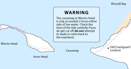
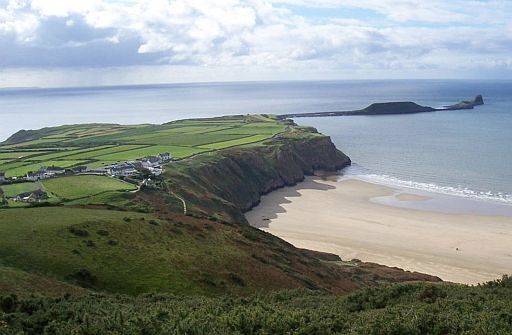 • Worms Head & Rhossili Bay. • Worms Head & Rhossili Bay.
• Worms Head derives its name from the Old English wurm meaning dragon.
In Britain's Favourite Walks Top 100 stond een klein deeltraject
daarvan op de 28 ste plaats.
Dat is tamelijk hoog. Het was:
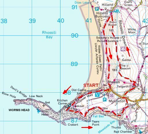
28. Rhossili,
.... Gower Peninsula AONB ........... 11 ½ km ........... licht
Visit when the sun is shining and you’ll be treated to sparkling blue-green water and miles of sand.
There are various trails offering fantastic views and a landscape rich in mythology and history.
• Start and finish: Rhossili.
• Worms Head & Rhossili Bay.
• Worms Head derives its name from the Old English wurm meaning dragon.
ANWB Campings:
Zie voor een overzicht anwb.nl/wales.
Wildkamperen:
Een nachtje bivakkeren ('s avonds de trekkerstent opzetten en 's morgens
weer
afbreken) geeft geen problemen.
Verdere info:
Rother Wanderführer Wales, Tour 36
https://osmaps.ordnancesurvey.co.uk/route/167275....
|
The National Trust is our biggest coastal landowner

In the summer of 1965, a young geography professor called John
Whittow
and a few dozen students set out for a walk along the shores
which would
change the character of the coast forever.
They spent their holiday forcing their way through bramble thickets,
hurdling barbed wire and jumping streams to survey on foot every mile
of the coast of England, Wales and Northern Ireland, concluding that
a
third of this uniquely varied 3,000-mile coastline was pristine,
precious
and worth preserving.
Their findings kick-started Enterprise Neptune, a fundraising campaign
for the National Trust which after half a century has saved 742 miles
of
beach, cliff, estuary and bay from development or destruction. |
Boeken met informatie:
• Zoek voor deze beste kustwandelingen één van de twee onder-
...staande.. wandelboeken van Andrew McCloy.
...Een geweldige aanwinst voor je wandelbiebje !
• Je kunt deze wandelingen óók zónder die boeken goed doen.
... De benodigde.informatie staat meestal ook in een wandelgids en
... kaart van een..langeafstandspad. Wel heb je dan wat minder
... leuke achtergrondinfo.
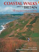
Coastal Walks Around Britain,
.... 15 Magnificant Weekend Walks,
.... Andrew McCloy,
.... New Holland Publishers, 2008
.... ..
|
|
In 2011 is Coastal Walks Around Britain met wat kleine wijzigingen
opnieuw uitgebracht,
maar nu onder de titel:
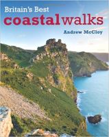
Britain's Best Coastal Walks:
Britain's Best Coastal Walks,
.... Andrew McCloy,
.... New Holland Publishers, 2011
|
|
• Deze twee boeken zijn alleen nog antiquariatisch te krijgen.
• Zoek eerst naar Britain's Best Coastal Walks uit 2011.
...Kun je dat niet vinden,
probeer dan Coastal Walks Around Britain,
...uit 2008. |
... Deze wandelsite is niet-commercieel, onafhankelijk en gratis.
... Dat is enkel mogelijk door steun van de bezoekers.
...
... Heb je hier goede info gevonden, toon dan je waardering door
een
... kleine donatie voor het vele werk.
... .Zo kan de website ook gratis blijven en uitgebouwd worden!
... • Betaal met deze knop in een paar klikken via je eigen PayPal-saldo.
... • Heb je zelf nog geen PayPal-rekening, dan kun je toch via PayPal
...... vanaf je creditcard geld overmaken.
....Uiteraard kun je ook doneren door overschrijving op mijn
.. ING-bankrekening:
.. IBAN : NL38 INGB 0003 5057 89
.. BIC : INGBNL2A
.. t.n.v. P. C.M. Smulders. |
Weet je aanvullingen en verbeteringen van deze tekst?
Graag een e-mail naar:

En tot slot: veel wandelplezier !
Piet Smulders, 2018
 .. . .. .  . .. . .. 
|
|