.
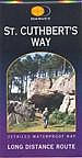
........... ST CUTHBERT'S WAY
........
....
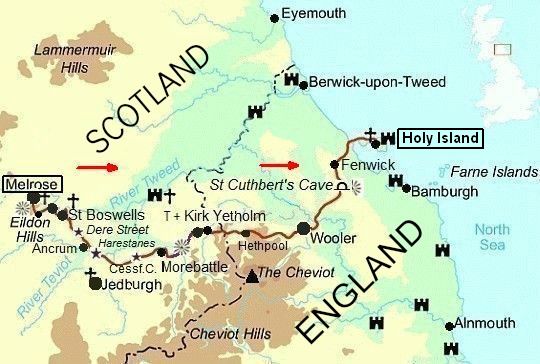
.. Melrose – Holy Island (England) = 102 km
St Cuthbert:
Cuthbert was a native of the border country who received his calling aged
16 in
650 AD. From that day till his death he served the church, finally
achieving the
rank
of Bishop.
He was beatified (zalig verklaard) some 11 years after his death when
his coffin
was
opened, and his remains found to be perfectly preserved.
These remains were removed from Lindisfarne in 875 AD, when the island
community was threatened by Viking raids, and finally came to rest in
Durham Cathedral.
St Cuthbert's Way =
wandelen door Scottish Borders en Cheviot Hills
naar Holy Island.
• St Cuthberts Way is één van de vier Schotse langeafstandspaden die
.. in de Britain's favourite walks Top 100 stonden.
.. Het eindigde op de 51 e plaats.
(
Vanzelfsprekend een stuk lager dan de
.. zeer populaire West Highland Way die
op de 14e plaats eindigde.)
• It is a long distance footpath linking a number of places associated with
.. the
life of
St Cuthbert.
.. It starts in Melrose (in the Scottish Borders), where St Cuthbert began his
.. ministry
and over the Cheviots to Lindisfarne (later known as Holy Island),
.. the island wherehe was ordained Bishop.
• It includes a large variety of quite unspoilt countryside:
... - the Eildon Hills (heuvels met fraai uitzicht over het Borderland),
... - the Tweed valley (origin of the famous woollen cloth),
... - the Cheviot Hills (origin of one of the most famous breeds of sheep),
... - and the coastal flats, sanddunes, and a causeway
......(= dam; verhoogde weg ) passable only at low tide.
• The small historic towns en route - Melrose and Wooler - are equally
.. unspoilt and offer a pleasant contrast with the very thinly populated
.. countryside.
• There is an abundance of historical remains including ruined abbeys at
.. Melrose, and Lindisfarne.
| ST CUTHBERT'S.WAY: .MELROSE–LINDISFARNE (HOLY ISLAND) |
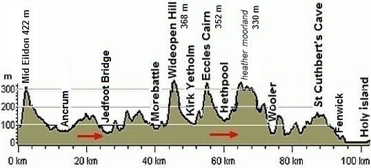
..... ( De route komt nauwelijks boven de 300 m uit ! )
|
|
.jpg)
• Als je met een lichte dagrugzak loopt , terwijl je de hoofdbagage laat
.. bezorgen, kun je deze wandeltrektocht in 6 dagen lopen
.. (zie verderop bij Van dag tot dag).
• Ga je echter met trekkingrugzak en tent dan heb je zo'n indeling niet
.. nodig. Je bent dan vrij in doen en laten en kunt 's avonds altijd wel een
.. tentplek vinden.
.. Je hebt dan wel een dag méér nodig, omdat je met een trekkingrugzak
.. minder kilometers per dag aflegt.
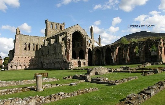
• Melrose Abbey met één van de drie Eildon Hills rechtsboven.
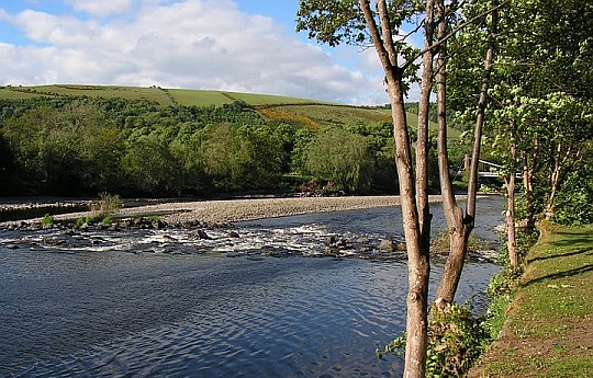
• The River Tweed at Melrose. This is one of Scotlands most important salmon rivers.
• Als het een tijdje niet geregend heeft, krijg je mooi helder rustig stromend water,
.. zoals hier op de
foto.
Dit is ideaal voor de vliegvissers.
.. Na regen veranderd de rivier echter in een woeste stroom met veel
slib erin.
.. Dan blijven de vissers thuis.
Beste periode:
Juli en augustus zijn de beste maanden.
Juni kan nog koude dagen hebben en september is al vroeg donker.
Ter geruststelling:
dit gebied is essentieel anders dan West-Schotland.
Hier in Oost-Schotland regent het weinig en heb je
geen last van
'midges'
en
muggen.
Rainfall drops almost an inch (2,54 cm) for every mile (1609 m) you go east.
( Voor het weerbericht ga je naar www.metoffice.gov.uk/ )
.Climate – Station Galashiels |
apr |
mei |
jun |
jul |
aug |
sep |
okt |
.Gemiddelde maximumtemp. °C |
11
|
14
|
16
|
19
|
18
|
15
|
12
|
.Maandsom neerslag (mm) |
49
|
55
|
61
|
64
|
67
|
65
|
86
|
| ( Gem. maximumtemp. De Bilt ) | 14
|
18
|
20
|
23
|
23
|
19
|
15
|
Zwaarte:
Meeste dagen middelzware wandelingen. Enkele dagen licht.
Routemarkering: zeer goed.
Soms kan er in de bebouwde kom een bordje ontbreken, maar dat geldt
voor
alle langeafstandspaden.
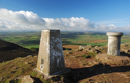
• Eildon Mid Hill. The top is marked by a trig point and a view indicator - the latter
.. reveals that this
must rank as perhaps the finest viewpoint in the Borders,
.. with the steep upper slopes ensuring the
outlook has depth as well as distance.

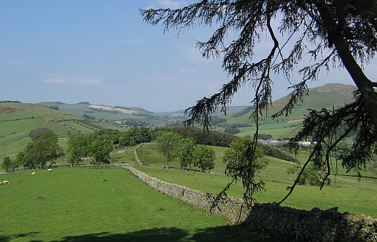
• Looking back to the Eildons from Whitelee.
Bevoorrading:
• Levensmiddelen: Zie de food shop-symbooltjes op je Harvey-map.
.. Je passeert dus vrijwel iedere dag een kleine food shop.
.. Alleen bij Wooler
moest
je voor 1½ dag inslaan.
...Vraag wel telkens bij de winkel of
het volgende dorp er nog steeds een
...heeft.
...Bij Ancrum bijvoorbeeld was ze zo klein dat de winkel ieder moment haar
...deuren
permanent kan sluiten.
• Drinkwater: Vul de veldflessen bij het verlaten van de dorpjes.
.. Neem geen water uit de beekjes om te koken. Er zijn hier te veel
.. schapen
die het
oppervlaktewater ongeschikt maken om te drinken.
ANWB Campings:
Zie voor een overzicht anwb.nl/schotland.
Wildkamperen:
Een nachtje bivakkeren ('s avonds de trekkerstent opzetten en 's morgens
weer
afbreken) geeft geen problemen.
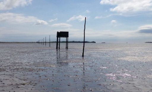
Uitgezonderd Holy Island, daar is het uitdrukkelijk verboden.
Hoogtepunten:
• Melrose Abbey.
• the Eildon Hills
• the River Tweed.
• Dere Street (Roman Road).
• the Cheviot Hills (heather moorland).
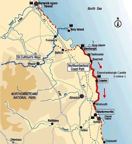
• Wooler ― Holy Island ..... 29 km
... From Wooler over Westwood Moor, then onto St Cuthbert's Cave and
... finishing at
Holy Island via the tidal causeway (= getijdendam).
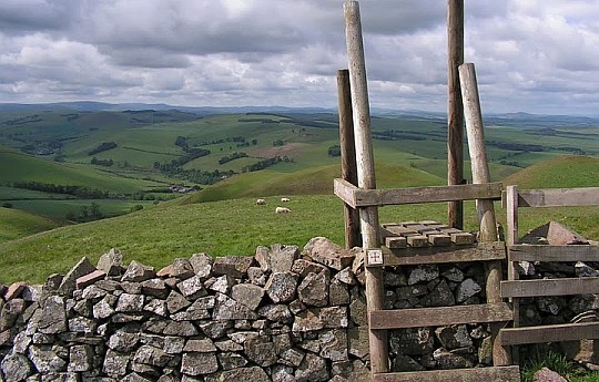
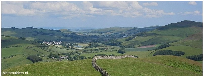
• View from Wideopen Hill.
• Descending from Wideopen Hill into Bowmont Valley south of Town Yetholm.
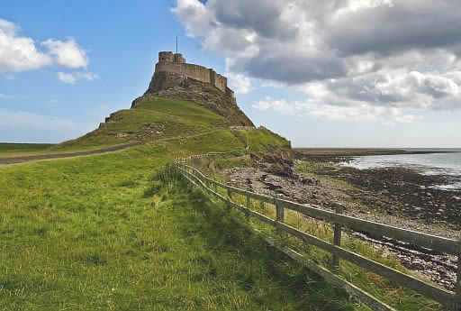
Lindisfarne, or Holy Island,
has an illustrious history: |
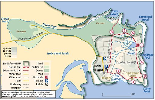
Lindisfarne has a nature trail: |
Eindbeoordeling:
St Cuthbert's Way is een échte Top Trail van begin tot eind !
Beste websites:
![]() www.stcuthbertsway.net/
www.stcuthbertsway.net/
![]() www.st-cuthberts-way.co.uk
www.st-cuthberts-way.co.uk
![]() www.ldwa.org.uk
www.ldwa.org.uk
![]() www.walkhighlands.co.uk/borders/st-cuthberts-way.shtml
www.walkhighlands.co.uk/borders/st-cuthberts-way.shtml
Sites komen en gaan; dat valt niet bij te houden.
Googel daarom ook een keer naar st cuthbert's way en bekijk de eerste
10 (evt. 20)
resultaten.
Daar zitten de belangrijkste sites wel tussen.
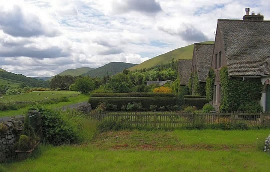
• Hethpool Cottages (in the College Valley).
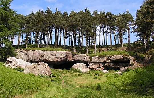
• St Cuthbert's Cave, near Fenwick, a dramatic sandstone overhang where the
.. saint’s body was taken
during the
flight of the monks from Lindisfarne in
.. 875 AD after a Viking raid.
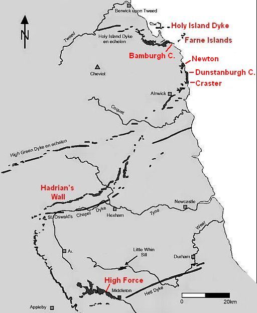
Whin Sill: The Whin Sill is one of the special geological features of the North Molten origins:
The original sill: |
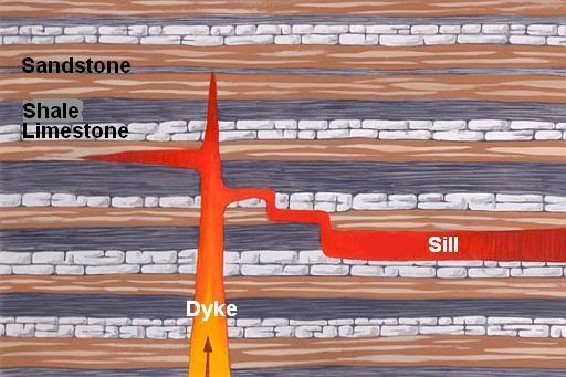
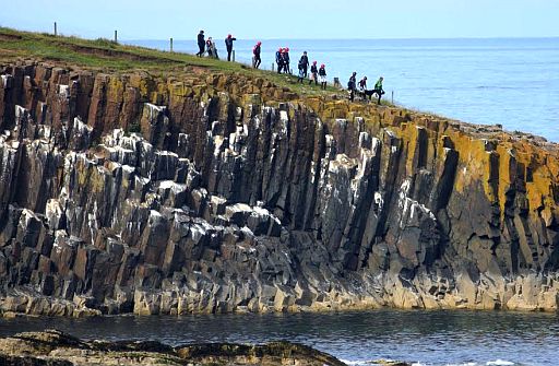
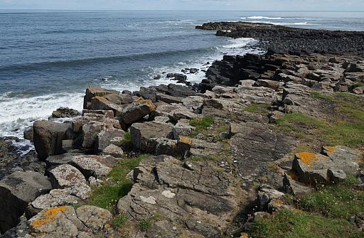
Where to see the Whin Sill:
 . 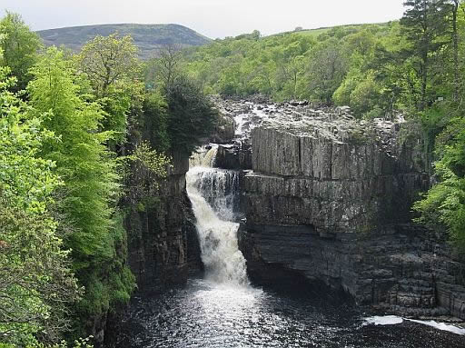 • The Whin Sill is also responsible for one of Britain’s most famous waterfalls: • The Whin Sill is also responsible for one of Britain’s most famous waterfalls: ...High Force. .. Here the River Tees falls more than 20 m over the resistant rocks of the Whin Sill. • Two types of rock can be seen at the falls. .. The lower rocks are horizontal sediment layers. .. The upper rocks are dark dolerite and has vertical joints. .. They are much harder than the sediment layers underneath. • This tough dolerite is resistant to erosion, which explains the location of the .. waterfall. .. Where there is no dolerite, the valley broadens out and waterfalls are absent, but .. other bands of dolerite create waterfalls just a short distance upstream at ...Cauldron Snout and downstream at Low Force. |
Van dag tot dag volgens Arrive in Melrose. (Melrose en omgeving is zeer mooi! ) 1. Melrose ― Ancrum .... 22½ km .....Middelzwaar... ↑ 430 m 2. Ancrum ― Morebattle .. 19 km .... Middelzwaar ... ↑ 370 m 3. Morebattle ― Kirk Yetholm .... 11 km..... Licht.... ↑ 270 m
4. Kirk Yetholm ― Wooler .. 21 km .. Middelzwaar . ↑ 620 m 5. Wooler ― Fenwick ... 19 km..... Middelzwaar .. ↑390 m 6. Fenwick ― Holy Island ... 10 km .... Licht.... ↑0 m - While exploring the island you should visit: |

Verlenging St Cuthbert's Way mogelijk:
|
Wil je de St. Cuthbert's Way lopen ? |
| aaaa |
SNP Natuurreizen heeft in Groot-Brittanië ook wandelreizen:
Hun reizen met een zwaarte van 1 of 2 zwarte cirkeltjes komen het beste overeen met mijn wandelingen.
Je maakt dan niet te veel hoogtemeters en wandeluren per dag.
Zie: www.snp.nl/reizen/
| aaaa |
Te bestellen bij: |
.. . Overnachtingsmogelijkheden: West Highland Way, Great Glen Way en St Cuthberts Way zijn populaire paden. Daardoor zijn er problemen bij het vinden van accommodaties. Kijk bij Accommodation and services along the way op |
... Deze wandelsite is niet-commercieel, onafhankelijk en gratis. ... • Heb je zelf nog geen PayPal-rekening, dan kun je toch via PayPal ...... vanaf je creditcard geld overmaken. ....Uiteraard kun je ook doneren door overschrijving op mijn |
Weet je aanvullingen en verbeteringen van deze tekst?
Graag een e-mail naar:
![]()
![]() ....
.... ![]() ....
.... ![]()
LAATST BIJGEWERKT : 7-1-2019