.
...........ARRAN COASTAL WAY
. Meerdaags circuit vanuit Brodick (anticlockwise).101 km
Onvolledige pagina; wordt te zijner tijd aangevuld !.
Arran:
• Arran is een eilandje (30 x15 km) voor de kust bij Glasgow.
• Het wordt door de Highland Boundary Fault in tweeën gedeeld.
.. Men noemt dit eiland daarom ook wel Schotland in het klein'
.. (hoewel die
bijnaam
te
weinig recht doet aan haar sterk eiland karakter).
• Het noordelijke deel is "mountainous and rugged" (Highland scenery)
.. met graniettoppen en diepe
dalen.
• Het zuidelijke deel bestaat uit "lowlands and rolling hills"
.. (Lowland scenery) met landbouwgronden,
bos en veen.
.. Daar bevinden zich ook de meeste nederzettingen.
• En dan is er natuurlijk de gevarieerde kustlijn: with rugged cliffs,
.. spectacular caves, sandy beaches, landslips and
boulder fields.
The Arran Coastal Way:
• The Arran Coastal Way combines coastal paths, forest tracks, roads and
.. stretches
of beach to encircle this beautiful island.
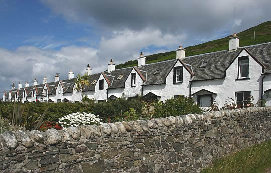
• You walk through many of Arran’s charming coastal villages with their
.. white
stone cottages and ancient Celtic and Norse names; Lagg, Sannox,
.. Kildonan and Corrie.
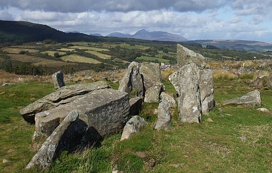
• It also passes many reminders of Arran's rich history including:
.. - Neolithic chambered cairns,
.. - Bronze Age stone circles,
.. - Iron Age hill forts,
.. - the ruins of Kildonan and Lochranza Castles,
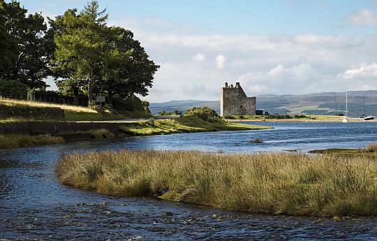
.. - the warm red sandstone pile of Brodick Castle, surrounded by
.... magnificent gardens,
.. - salt pans,
.. - ruined crofts abandoned during the Clearances and
.. - King's Cave, where according to legend Robert the Bruce was inspired
.. . by the
determination of a small spider.
• Most of the time you follow the coastline.
• Exceptions are the two inland loops:
.. - On the first day you walk to the shoulder (630 m) of Goat Fell ( 874 m),
.... the
island's highest
mountain.
.. - On the last day you walk from Whiting Bay an inland loop to see the
.... Glenashdale Falls and Iron Age Fort.
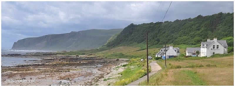
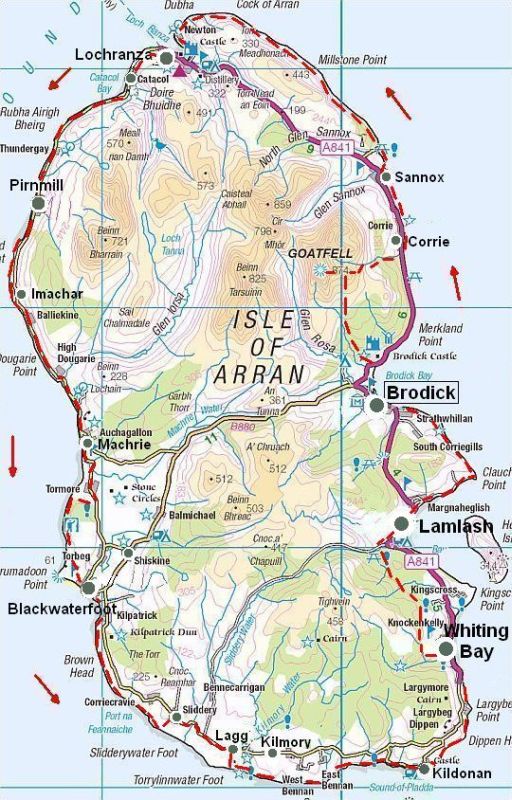
| . ARRAN . COASTAL . WAY .. (anticlockwise) |

• Het eiland heeft een lengte van circa 30 km en breedte van 15 km.
• Belangrijkste dorpen zijn: Lamlash (± 1100 inw.), Brodick (650) en Whiting Bay (600).
.. ( De andere dorpen en gehuchten zijn veel kleiner: enkele honderden inwoners.)
Fotoalbum:
|
|
Lengte en tijdsduur: ... km
• Als je met een lichte dagrugzak loopt , terwijl je de hoofdbagage laat
.. bezorgen,
kun je deze wandeltrektocht in .. dagen lopen
.. (zie verderop bij Van dag tot dag).
• Ga je echter met trekkingrugzak en tent dan heb je zo'n indeling niet
.. nodig.
Je bent dan vrij in doen en laten en kunt 's avonds altijd wel een
.. tentplek vinden.
..Je hebt dan wel .... méér nodig, omdat je met
een trekkingrugzak
minder
.. kilometers per dag aflegt.
Het noordelijke deel is een glaciated upland:
During the Ice Age, glaciers eroded a trail of features including:
- corries ( = karen), met daarin tarns (= kaarmeertjes)
-
arêtes ( = graten)
-
pyramidal peaks (= pyramidale pieken),
-
U-shaped valleys (= dalen met U-vormig dwarsprofiel)
Zie voor een goede introductie van de glaciale erosie tijdens Ijstijden:
![]() engeland_glaciated-upland-landscapes
engeland_glaciated-upland-landscapes
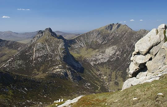
De granietbergen in het noordelijke deel van Arran tonen het effect van
de glaciale erosie gedurende
de ijstijd(en).
De fotograaf stond op North Goatfjell en keek naar het noordwesten.
Links zie je Cir Mhòr en rechts Caisteal Abhail.
Het zijn allebei Corbetts, d.w.z:
berg, of heuvel, hoger dan 2500 voet (762 meter)
met aan alle kanten
een hoogteverschil van
minimaal 500 voet (152 meter)
met andere toppen.
(Indien de berg hoger is dan 3000 voet (914 meter), dan wordt deze
gekwalificeerd
als een Munro)
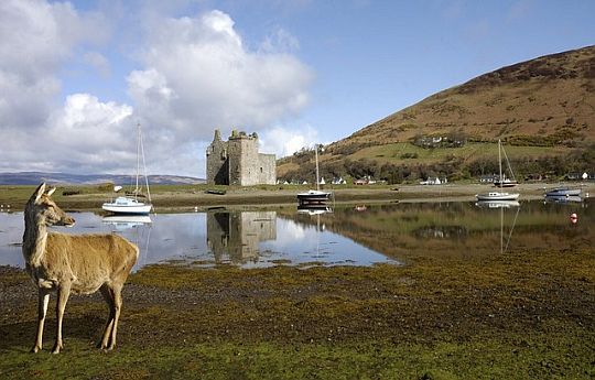
Edelhert aan de kust bij Lochranza. Op de achtergrond de kasteelruïne.
Beste periode:
..
..
( Voor het weerbericht ga je naar www.metoffice.gov.uk/ )
.Climate – Station Machrihanish |
apr |
mei |
jun |
jul |
aug |
sep |
okt |
.Gemiddelde maximumtemp. °C |
11
|
14
|
16
|
17
|
18
|
16
|
13
|
.Maandsom neerslag (mm) |
77
|
63
|
73
|
78
|
95
|
109
|
144
|
| ( Gem. maximumtemp. De Bilt ) | 14
|
18
|
20
|
23
|
23
|
19
|
15
|
Zwaarte:
Middelzware dagwandelingen.
De dagwandelingen varieren van ........
Zie verderop bij Van dag tot dag voor meer details.
• Pay attention to the times of the tide - particularly on the lower
.. coastal
section.
• Walking on the shoreline you will encounter boulder fields; these can
.. be treacherous in wet weather.
.. ( although the‘boulder hopping’ is tough, it is worth
the challenge to
.. have
the chance to see seals, dolphins, porpoise,
sea otters
and, if you
.. are
really lucky,
the large black fin of the
basking shark. )
• Also be prepared
for a bit of road walking.
• Many parts of the Coastal Way are simple, basic paths that can be
.. muddy or
boulder strewn and which will, on occasion, require clambering
.. over
rocks.
Routemarkering:
The route has been waymarked, but they can be obscured by dense foliage
in
the summer
months.
De Twaalf Apostelen, Catacol.
Bevoorrading:
• Levensmiddelen: Zie de food shop-symbooltjes op je Harvey-map.
• Drinkwater: Vul de veldflessen bij het verlaten van de dorpjes.
ANWB Campings:
Zie voor een overzicht anwb.nl/schotland.
Wildkamperen:
Een nachtje bivakkeren ('s avonds de trekkerstent opzetten en 's morgens
weer
afbreken) geeft geen problemen.
Hoogtepunten:
• ....
• Brodick Castle, once the ancient seat of the Dukes of Hamilton, houses
.. a glorious collection of furniture, with some pieces dating as far back as
.. the
17th century.
.. The garden has been lovingly restored and the grounds contain
.. numerous paths offering great views of the island.
• ....
Zie voor een goede introductie van de verschillende kustvormen:
![]() engeland_coastal-landscapes
engeland_coastal-landscapes
Wildlife:
Door de diversiteit aan landschappen op Arran tref je er veel verschillende
dieren
aan: Zeehonden, Steenarend, de Alpensneeuwhoen,
Schotse
Sneeuwhoen,
diverse zeevogels als Eidereenden, Roodkeelduiker en
Noordse Stormvogel.
Arran's rich and diverse wildlife is a special feature of the trail.
• The coastline supports a wide variety of birds including, eider, gannet,
.. cormorant, shelduck, oystercatcher, red-breasted merganser,
redshank,
...red-throated diver and fulmar.
.. Seals are often seen basking on the shores of the island.
• The northern mountains are natural home of the red deer.
.. Raise your eyes from your path and you may rewarded with
a majestic
.. golden
eagle, gliding hen-harrier, or
amongst the heather bring up a
.. fluttering grouse or curlew.
FOTO:
..............
The Highland Boundary Fault: A significant geological discontinuity, the Highland Boundary Fault
Active during the Caledonian mountain-building episode, a plate tectonic collision which took place from Mid Ordovician to Mid Devonian periods |
.jpg)
Eindbeoordeling:
....
Beste websites:
![]() http://coastalway.co.uk/
http://coastalway.co.uk/
![]() www.walkhighlands.co.uk/arran/arran-coastal-way.shtml
www.walkhighlands.co.uk/arran/arran-coastal-way.shtml
![]() www.contours.co.uk/walking-holidays/arran-coastal-way.php
www.contours.co.uk/walking-holidays/arran-coastal-way.php
Sites komen en gaan; dat valt niet bij te houden.
Googel daarom ook een keer naar ... en bekijk de eerste 10 (evt. 20)
resultaten.
Daar zitten de belangrijkste sites wel tussen.
FOTO
....
Van dag tot dag volgens Arrive in Brodick,
where your first nights accommodation has been 1. Brodick—Sannox (via Goatfell ridge) . 13 km .Lichte wandeling 2. Sannox — Lochranza .. 14 ½ km ......... 3. Lochranza — Machrie ..22 ½ km .........
4. Machrie — Lagg .. 18 ½ km ........ 5. Lagg — Whiting Bay .. 13 ½ km ......... 6. Whiting Bay — Brodick .. 19 km ......... |
| aaaa |
SNP Natuurreizen heeft in Groot-Brittanië ook wandelreizen:
Hun reizen met een zwaarte van 1 of 2 zwarte cirkeltjes komen het beste overeen met mijn wandelingen.
Je maakt dan niet te veel hoogtemeters en wandeluren per dag.
Zie: www.snp.nl/reizen/
| aaaa |
FOTO
.....
Te bestellen bij: |
.. . Overnachtingsmogelijkheden: ANWB campings: zie hier |
... Deze wandelsite is niet-commercieel, onafhankelijk en gratis. ... • Heb je zelf nog geen PayPal-rekening, dan kun je toch via PayPal ...... vanaf je creditcard geld overmaken. ....Uiteraard kun je ook doneren door overschrijving op mijn |
Weet je aanvullingen en verbeteringen van deze tekst?
Graag een e-mail naar:
![]()
![]() ...
... ![]() ...
... ![]()
LAATST BIJGEWERKT : 7-1-2019