.
.......SOUTH .. WEST . COAST . PATH:
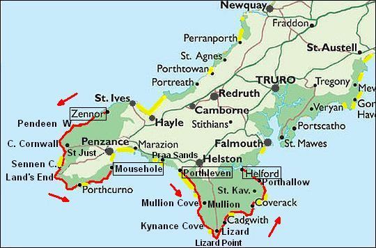
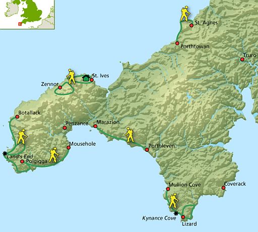
...................West . Cornwall
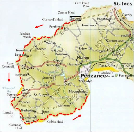
- Penwith (Zennor – Mousehole) ... 59 km
- The Lizard (Porthleven – Helford) ... 60 km
.
| . SOUTH WEST COAST PATH . ( West Cornwall ) |
Geel = strand. .... Groen = Heritage Coast.
A walk along great cliffs, interspersed with coves (inhammen) and beaches.
A wild and rugged landscape that gives you a real feeling of remoteness.
• West Cornwall is een plateau op ongeveer 100 m boven zeeniveau.
Op je Harvey-strookkaart deel 3 zie je dat daar ook een aantal heuvels bovenuit steken. Ze zijn wit gekleurd (=Moorland).
• Overal waar een beekje in zee uitmondt, is het bezig zich in te snijden in het plateau. Je vindt daar een nauw, bebost dal. De diepste van die aanpassingsdalen liggen vrijwel op zeeniveau. Dat betekent voor de wandelaar al gauw 75 hoogtemeter tamelijk steil naar beneden en vervolgens weer omhoog.
• Het gesteente van Land's End is graniet en dit verklaart de mijnbouw van de mineralen zoals koper en tin, en de aanwezigheid van vele prehistorische monumenten. De prehistorische mens gebruikte graag de keiharde graniet voor de bouw van grafkamers en dergelijke.
• Het South West Coast Path is een écht kustpad; de zee is altijd zichtbaar aanwezig.
• Meestal loop je bovenlangs de kliffen, waar je een mooi uitzicht hebt.
Zo nu en dan ook beneden over stranden en langs haventjes.
• Constant aanwezig zijn o.a.:
Bracken (Adelaarsvaren), .Gorse (Gaspeldoorn-soorten) en.Heidesoorten.
.Bijna afwezig daarentegen Bomen/Bos (vrijwel alleen in de dalen).
• Voortdurend hoor je krijsende zeevogels en met wat geluk zie je:
- Red-billed Chough (Alpenkraai) (Pyrrhocorax pyrrhocorax),
En beneden in zee misschien:
- Grey seal (Grijze zeehond) (Halichoerus grypus), en/of
- Basket shark (Reuzenhaai) (Cetorhinus maximus) trawling for plankton.
Voor dit pad is een verrekijker dan ook een must !
• Op dit langeafstandspad ontmoet je opvallend veel Duitse wandelaars.
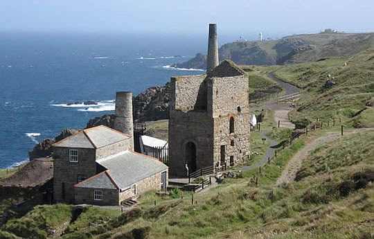
• The relics of Cornwall's once thriving Tin mines at Levant.
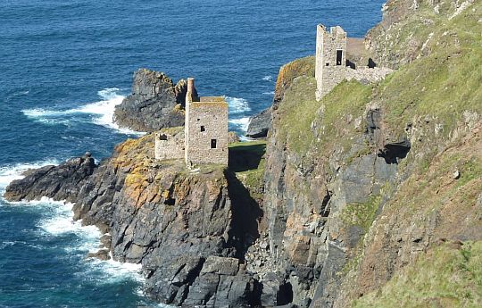
• The disused tin mines at Botallack Head cling to the very cliff edge.
Introduction West Cornwall:
• The coastline of the Land's End peninsula between St Ives and Penzance is one of the most beautiful in Britain, with rugged granite cliffs dotted with the ruins of old tin mines.
• In spring and early summer the clifftops are carpeted with a dazzling array of wild flowers.
• As well as the delightful port of St Ives, with its narrow winding streets and picturesque harbour, the path visits
- the pretty fishing villages of Mousehole, Lamorna and Sennen Cove;
- the open-air Minack Theatre, perched spectacularly on the cliffs above beautiful Porthcurno Bay; and
- the sleepy mining village of St Just.
• The stretch of the coast around the beautiful Lizard Peninsula to Falmouth, visits:
- the picturesque island of St Michael's Mount, which is linked by a tidal causeway (getijdendam) to the mainland at low tide;
- the idyllic coves of Kynance and Gunwalloe, the smugglers' hideawaysof Prussia Cove and Coverack; and
- the pretty fishing villages of Porthleven, Mullion and Cadgwith, where white-washed thatched cottages cluster around the tiny harbour.
The rugged cliffs of red-green serpentine around The Lizard provide a superb contrast to the tranquil woods, creeks and inlets of the Helford River so beloved by Daphne Du Maurier.
De volgende twee gedeelten hebben top trail - kwaliteit:
.1. Zennor – Mousehole (op het schiereiland Penwith (= Land's End)
This coastline has rugged granite cliffs dotted with the ruins of old tin mines.
2. Porthleven – Helford (op schiereiland The Lizard)
The rugged cliffs of red-green serpentine around The Lizard provide a superb contrast to the tranquil woods, creeks and inlets of the Helford River.
Hoogtepunten daarin volgens www.ldwa.org.uk:
ad 1. . Zennor ― Cape Cornwall .... (18 km)
Scenic clifftop walking in a past mining landscape.
ad 2. . Mullion ― Lizard .. (13 km)
Coves, seabirds, rugged serpentine cliffs once part of an ocean floor.
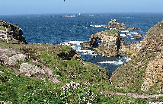
• Granite rocks at Land's End.
• Land's End, de meest westelijke punt, is een woestenij van rotsen.
• In het hoogseizoen is het veel drukker dan op deze foto. Het is dan verpest door massatoerisme.
Foto's:
www.penseelmourik.nl/southwestc
Lengte en tijdsduur: 119 km
• Als je deze wandeltrektocht met een lichte dagrugzak loopt , terwijl je de hoofdbagage laat bezorgen, kun je het traject in 6 dagen doen(zie verderop bij Van dag tot dag).
• Maak je deze wandeltrektocht met trekkingrugzak en tent dan heb je zo'n indeling niet nodig. Je bent dan vrij in doen en laten en kunt 's avonds altijd wel een tentplek vinden.
Je hebt dan wel 1 tot 2 dagen meer nodig, omdat je met een trekkingrugzak minder kilometers per dag aflegt.

• The Minack Theatre at Porthcurno (een in de kliffen uitgehouwen openlucht-theater).
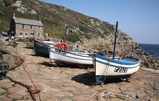
• Penberth, small fishing boats lie pulled up on the rocky beach.
• De vissersboten worden hier nog steeds met een lier het strand opgetrokken.
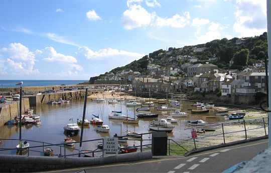
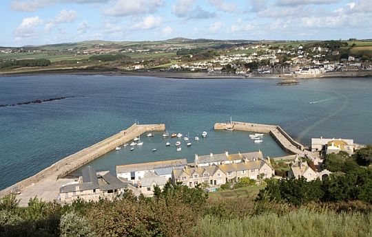
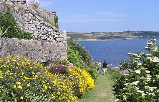
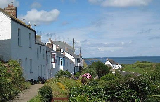
• Arguably Cornwall's most attractive harbour, Mousehole (pronounced 'Mowzul') is a classic.
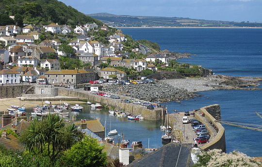
• The two harbour arms can be linked by boards to prevent stormy seas from entering the enclosed area.
• Mostly full of fishing boats, Mousehole retains a sense of antiquity, assisted by the proximity of its quayside cottages.
Beste periode:
Half juni ― half september is beste periode. Je bent hier aan de kust. Dat betekent dat het op bewolkte dagen met wind zelfs in het begin van juni nog koud aanvoelt.
September is al vroeg donker.
De neerslag is seizoensgebonden. In de winter valt er veel, maar de zomer is droog.
.Climate – Station Culdrose (78m) |
apr |
mei |
jun |
jul |
aug |
sep |
okt |
.Gemiddelde maximumtemp. °C |
12
|
15
|
17
|
19
|
19
|
17
|
14
|
.Maandsom neerslag (mm) |
67
|
60
|
61
|
62
|
67
|
72
|
105
|
| ( Gem. maximumtemp. De Bilt ) | 14
|
18
|
20
|
23
|
23
|
19
|
15
|
Zwaarte:
Middelzware dagwandelingen.
• Het pad bevindt zich meestal vlak onder de 75m-hoogtelijn.
Daar golft het op en neer met talloze korte ups and downs van enkele tientallen hoogtemeters.
• Daarnaast steek je nog een aantal deep, steep-sided valleys over.
Dat betekent telkens bijna 75 m steil naar beneden en daarna weer omhoog.
Dit alles bij elkaar maakt deze route middelzwaar.
(Een uitzondering op bovenstaande regel is het gedeelte tussen Land's End en Gwennop Head. Daar is het een lichte wandeling over een plateau met heather moorland.)
Routemarkering:
Zeer goed, zoals gebruikelijk bij "national trails".
Openbaar vervoer: goed.
Je kunt desgewenst met openbaar vervoer naar het beginpunt/eindpunt van de dagwandeling reizen.
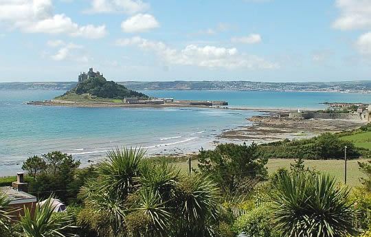
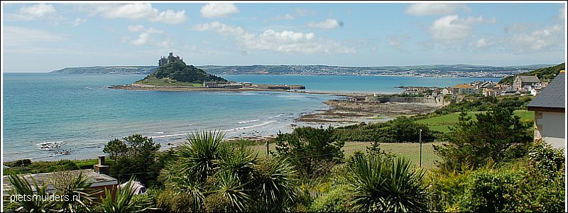
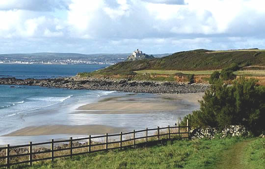
• St Michael's Mount is een getijdeneiland.
• Het is een granietrots waaromheen alle leisteen weggeërodeerd is.
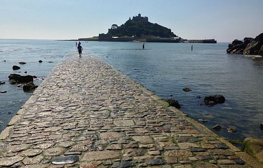
• Here is a good example of how we can see the effects of climate change over time - particularly in the increased speed of sea-level rise:
- In the 15 th century the tombolo (= a bar extending out to an island) was passable 3 hours either side of low-water.
- Today the tidal causeway (getijdendam) is only open for 2 hours either side and in 40 years from now it will be less than 1 hour.
• St Michael's Mount, cut off by the tide from mainland Marazion.
• Noordwaarts kijkend vanaf St Michael's Mount met Marazion in de verte.
• Rechts van de jachthaven zie je de ondergelopen tidal causeway (=getijdendam)
• Op St Michael's Mount.
• Je staat hier enkele kilometers ten oosten van St Michael's Mount boven op de lage kliffen.
• Ze bestaan uit grondmorene en zijn erg instabiel. Daarom is er een hek voorgezet.
• Je kijkt over een strandje westwaarts. Midden op de foto zie je de kliffen ook als een bruine band.
Bevoorrading:
• Levensmiddelen: De Harvey-strookkaarten geven aan welke dorpjes een klein levensmiddelenwinkeltje hebben. Porthcurno bleek er geen meer te hebben. Daarom altijd even informeren of het volgende dorpje er nog steeds een heeft.
• Drinkwater: De Harvey strookkaarten hebben ook symbolen voor openbare toiletten ingetekend. Deze toiletten hebben drinkwater.
Nooit water uit de beekjes nemen vanwege intensely farmed land !
ANWB Campings:
Zie voor een overzicht anwb.nl/engeland
Wildkamperen (bivak):
Gaf mij geen problemen.
• Kynance Cove.
• Cadgwith. Er was hier overal fijn gaas over de rieten daken gespannen, om het nestelen van vogels te verhinderen.
• Coverack, Coastguard Cottages.
Hoogtepunten:
• St Ives,
• Zennor ― Cape Cornwall ... 18 km
Scenic cliff-top walking in a past mining landscape. (Geevor Tin Mine Museum, Pendeen and Levant Engine House, St. Just)
• het prachtige Heather moorland ten zuidoosten van Land's End,
• Minack Theatre, een in de kliffen uitgehouwen openlucht-theater,
• Penberth,
• Mousehole (pronounce: 'Mowzul'),
• Marazion & St. Michael's Mount (Britse versie van Franse Mont St. Michel)
St Michael's Mount, a granite isle, has defied erosion in comparison to the surrounding softer sedimentary rocks. A small, roughly circular intrusion of granite forms the Mount and the southern foreshore.
• Porthleven,
• Loe Bar en The Loe (het grootste meer in Cornwall),
• Mullion ― Lizard ... 13 km
Coves, seabirds, rugged serpentine cliffs once part of an ocean floor.
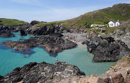
- Kynance Cove (uitzonderlijk mooie inham !).
• Cadgwith,
• Coverack.
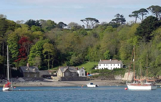
• Helford River, a ria (= het verdronken buitenste deel van een rivierdal).
Openbaar vervoer:
There is a decent bus network serving many of the villages along this part of the Cornwall coast, with most of the routes emanating from Penzance.
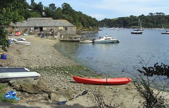
• Gillan Harbour in the Helford River. This river is a ria.
• A ria is a coastal inlet formed by the partial submergence of an unglaciated river valley.
• The south coast of England is a submergent coastline which contains many rias.
• St Anthony.
• Durgan.
Beware of unstable cliffs / falling rocks:
Het kustpad loopt grote stukken boven langs de klifrand. Op een aantal plaatsen nadert de terugwijkende klifrand tot op 1 meter het pad. Dit kan gevaarlijk zijn, indien het klif op die plaats ondermijnd is. Het overhangende gesteente zou dan kunnen afbreken en omlaagstorten.
Daarom geldt als regel:
• blijf boven op het klif op ruime afstand van de klifrand en
• beneden op het strand ver van de voet van het klif.
www.bbc.co.uk/news/uk-15251 (Cornwall cliff collapse film)
Aan de kust is wind een belangrijke standplaatsfactor:
Als je de kustlijn van West-Cornwall vergelijkt met die in Exmoor, dan kun je zien hoe belangrijk de invloed van de wind is op de vegetatie.
Aan de kust in West-Cornwall zie je alleen heidesoorten gemengd met
Bracken (Adelaarsvaren) en Gorse (Gaspeldoorn-soorten).
De planten blijven er laag bij de grond. Ieder die zijn hoofd boven het maaiveld uitsteekt, wordt door de sterke westenwinden genadeloos gegeseld.
In Exmoor is het een ander verhaal. De steile hellingen aan de kust bevinden zich in de luwte van de overheersende zuidwestenwinden. Vandaar de aanwezigheid van zelfs hellingbossen.
Eindbeoordeling:
Deze korte deeltrajecten zijn echte top trails.
Beste websites:
www.southwestcoastpath.org.uk
.................................................
www.luggagetransfers.co.uk
Sites komen en gaan; dat valt niet bij te houden. Googel daarom ook een keer naar south west coast path en bekijk de eerste 10 (evt. 20) resultaten. Daar zitten de belangrijkste wel tussen.
Zie voor een goede introductie van de verschillende kustvormen:
engeland_coastal-landscapes
Introductie South West Coast Path
Zie hiervoor: South West Coast Path
| aaaa |
- Penwith (Zennor – Mousehole) .. 59 km
- The Lizard (Porthleven–Helford). 60 km
Deze van dag tot dag is samengesteld uit o.a.:
www.trek-inn.com/self-gu
.........................................
www.hfholidays.co.uk/hol
Arrival:
Arrive at your first night’s accommodation at picturesque St Ives.
You will have time free to acclimatise, and perhaps to enjoy a walk
along the beautiful beaches or just explore the maze of narrow
cobbled
streets that
form this lovely Cornish town.
1. Zennor ― St Just.
... 18 km ... middelzwaar .
Scenic cliff-top walking in a past mining landscape.
(dit is het eerste zéér mooie deeltraject)
• Maak 's morgens eerst een korte transfer van St Ives naar Zennor.
• The path weaves in and out of small headlands(= kapen) and coves(=inhammen).
The terrain is tough, isolated and rugged but spectacular all at the
same
time with little habitation in sight.
Occasionally, seals may be spotted, frolicking in the sea.
From Pendeen Watch the Path still undulates but in a gentler pace,
passing Geevor Tin Mine Until 1990 it was an active mine, but now it
is
solely a museum. The setting is beautiful - the museum is perched
on
cliffs overlooking the sea.
Just half a mile away is the Levant Mine a tin and copper mine with a
working steam-powered beam engine, which was used to pump water
out of tunnels below the sea level.
The surrounding purply red soil adds further drama to the backdrop of
rugged cliffs and wild seas.
• Leaving the industrial heritage behind at Botallack, the clifftop walk
to
Cape Cornwall is superb with open views all round, passing the
ruins of Kenidjack Castle atop a headland (= kaap).
Enjoy the stunning views from Cape Cornwall; a mile inland is the
lovely village of St Just.
2. St Just ― Porthcurno
...19 km ... middelzwaar/licht
• Leaving Cape Cornwall behind, there is a considerable amount of
climb
and descent, footbridge crossing, rugged and bouldery terrain,
narrow in places. Dolphins and seals may be spotted off the coast.
• At low tide, you can walk along the beach of Whitesand Bay to Sennen Cove,
a lovely fishing village with a round house on its
harbour
front.
Enjoy the superb view back to the lighthouse at Cape
Cornwall.
The beach is popular with surfers.
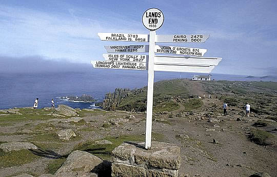
• Land's End, being the most south westerly point of the British Isle, can
be a
bit of a touristy affair but offers the ultimate photo opportunity
next
to the famous signpost.
There is also an exhibition about the Land's End to John o'Groats
journey.
More spectacular off the coast are the Armed Knight, a prominent
rocky
stack (=brandingspilaar, klip), and Enys Dodnan, a pierced islet (=doorboord eilandje).
• From here, the Path weaves around headlands and coves before eventually arriving at the world famous cliff-face Minack Theatre.
It is difficult to imagine a more dramatic location for an open air
theatre,
where the actors have to cope with the elements as well as
their nerves.
Not far inland from here is the small village of Porthcurno.
• De eerste helft (= tot Land's End) is een middelzware wandeling over
een ruw pad met vele korte ups and downs.
De tweede helft (= na Land's End)
is een lichte wandeling over
vrijwel horizontaal heather moorland.
3. Porthcurno ― Mousehole
... 12 ½ km . .. middelzwaar
• In today's world of satellite communication, it is difficult to imagine
the important role that the little village of Porthcurno played in
British
history.
For hidden from sight, a network of undersea cables reached out
from the village to all four corners of the British Empire and other
countries. You can visit the museum to see how this all happened.
• From the beach at Porthcurno, it is a steep climb out of the back of
Porth Curno onto the cliff and out towards Logan Rock, looking back
to
fabulous views of Minack Theatre nesting against the cliff face.
It is a continuous up and down and around coves and headlands,
through
a couple of woodlands.
• Pass Lamorna Cove, the Path skirts the windswept small wood that is Kemyel Crease before arriving at the quaint harbour village
of
Mousehole (pronounced 'Mowzul'), with its narrow streets.
• Bekijk op je gemak het mooie Mousehole.
• Neem daarna de bus naar Marazion, waar je overnacht.
• 's Morgens een korte transfer met de bus naar Porthleven.
(Je kunt desgewenst ook een extra dag nemen
voor Marazion en
Porthleven.
Je overnacht dan in Mousehole en de volgende morgen
naar Marazion
en in de loop van de middag naar Porthleven,
waar je overnacht.)
4. Porthleven ― Lizard
.... 21 km .... middelzwaar
Hiervan is Mullion Cove - Lizard (13 km) tweede zéér mooie deeltraject.
• The Path across Porthleven Sands is relatively gentle.
A couple of miles into the walk is Loe Pool, the largest freshwater lake
in Cornwall. It was once a tidal inlet and boats had sailed up to
Helston,
2 miles inland,
but heavy storms had created a shingle bar (kiezelwal), Loe Bar, cutting it off from the sea.
The sea here is dangerous and has claimed many ships over the
centuries; note the memorial to the 100 plus crew of HMS Anson.
At Gunwallow Fishing Cove, sandy beaches give way to rugged rocks
and cliffs.
• There are also a number of delightful and interesting coves:
Poldhu Cove where the Marconi Centre pay homage to the birth of
modern day communication when the first transatlantic radio signal
was
transmitted 1901; Mullion Cove with a harbour and village.
The best of all though must be Kynance Cove with a white sandy
beach, turquoise water and multi-coloured rock stacks (=brandingspilaren, klippen).
• The Lizard is an Area of Outstanding Natural Beauty, renowned for its
rare clovers and heathers and colourful serpentine rocks.
As you
approach the headland (= kaap) , there is superb view of the
village, which
is further inland.
5. Lizard ― Coverack
... 18 km ..... middelzwaar
• Lizard Point is the most southerly point on mainland Britain and from
now on follows a lush and generally sheltered coastline with delightful
coves and headlands.
Here you will find lush gardens, valleys filled
with trees and rushing water, and many thatched houses.
• The Lizard Lighthouse has for many centuries guided many a ship
safely around this most treacherous coast.
• Watch the sea hammer into the 100 metre deep hole that is the
Devil's Frying Pan, a 800 year old collapsed sea cave, before exploring
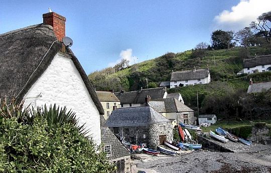
the little fishing village of Cadgwith with its narrow roads and
thatched cottages, nesting in the cliffs. This was the location of the
BBC TV show "The Fisherman's Apprentice", starring Monty Halls,
about the challenges
of being a small boat fisherman.
• Pass the disused buildings of an old serpentine mine at Poltesco on
the
way to Kennacks Sands for a low cliff and small valley walk over
gorse
and heather scrubs to Coverack.
6. Coverack ― Helford
.... 21 km .... middelzwaar
• Coverack is a lovely fishing village with a small harbour and a long
stretch of beach across the bay.
It is a low cliff walk from Coverack, not much above sea level.
It passes briefly through a wood, and, after Lowland Point,
Dean Quarry,
which until recently was busy with activities.
As the Path rounds Dean Point, the treacherous Manacles Reef is
visible
a mile from shore; many a ship have been lost there, sailing in
and out
of Falmouth. At Godrevy Cove, the Path detours inland before
coming
back out to sea briefly at Porthoustock.
• It swings back inland and follows a road for much of the way to Porthallow , which marks the halfway point of the Path.
Climb steeply out of Porthallow for a low cliff walk to Nare Point.
Enjoy the splendid views across Gillian Harbour and Creek, the River
Helford ria and Falmouth Bay. (A ria is a coastal inlet formed by the partial submergence of an
unglaciated river valley )
• Gillian Creek can be crossed on foot at low tide, otherwise, it will
entail an extra 2 miles of diversion inland, which is a worthwhile
detour, if you like creek walks and if you have the time and energy
to spare.
Once across, the Path passes the church of St Anthony-in-Meneage to
go
out to Dennis Head before curving back in along the Helford River with
great views of wildlife to Helford.
• The day ends with a ferry crossing from Helford to Helford Passage on
the other side of the river. It is a seasonal service. The advisable
alternative would be to use a taxi to avoid the 10 mile hike round!
| aaaa |
SNP Natuurreizen heeft hier ook een wandelreis:
Zie : www.snp.nl/reis/groot-britt
| aaaa |
Wandelgids: The South West Coast Path, Belangrijk: Strookkaarten: Harvey Maps 1 : 40,000 Bovenstaande is te bestellen bij: Boek met informatie over deze tocht: ........ |
..Deze wandelsite is niet-commercieel, onafhankelijk en gratis. Dat is enkel mogelijk door steun van de bezoekers. Uiteraard kun je ook doneren door overschrijving op mijn |
Weet je aanvullingen en verbeteringen van deze tekst?
Graag een e-mail naar:
![]()
![]() ....
.... ![]() ....
....![]()
LAATST BIJGEWERKT : 7-1-2019