.
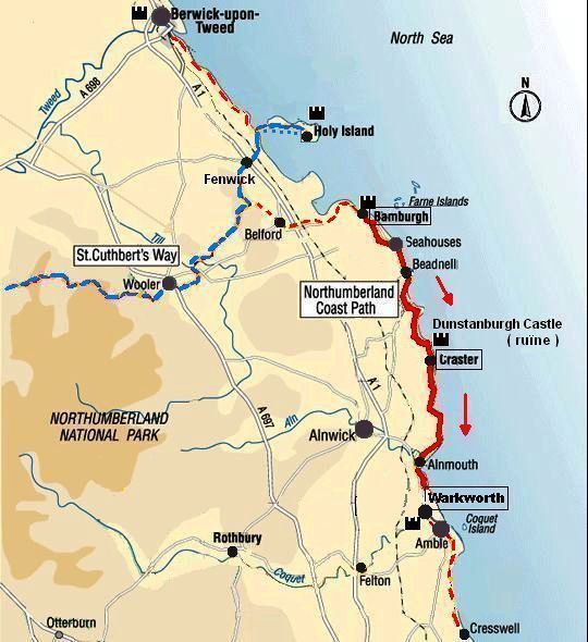
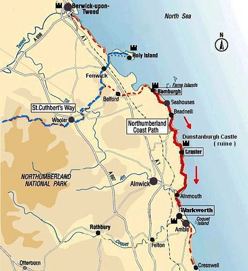
..NORTHUMBERLAND COAST PATH
... Bamburgh – Warkworth .. =.. 41 ½ km
.
| .NORTHUMBERLAND..COAST..PATH: BAMBURGH — WARKWORTH |
Northumberland:
Bamburgh used to be the capital of the Kingdom of Northumbria which
stretched
from the Firth of Forth (where Edinburgh is) all the way to the
Humber estuary
(where Hull is) which is why the county is still today
called
Northumberland.
Northumberland coast: sandy beaches and imposing castles
Samen met de kust van Cleveland (zie Cleveland Way) is de Northumberland
Coast
wellicht
het
mooiste stuk van de Britse noordoostkust.
Tevens is het een van de rustigste kustgebieden, omdat het klimaat hier
niet
direkt uitnodigend is voor strandtoeristen. Het zeewater is behoorlijk
koud en
de zandstranden liggen meestal nogal onbeschut.
Des te beter is de kust geschikt voor wandelingen over de stranden, door
de
duinen en boven over de
lage kliffen.
The Northumberland coast AONB is one of England’s finest unspoilt coastal
stretches,
characterized by:
1. sandy beaches (and dunes) with,
2. imposing castles perched
on rocky headlands, and
3. picturesque old coastal villages having hardly been changed by time,
4. wildlife rich off-shore islands.
There are few real cliffs, and if the tide is favourable you can wander the
open
sand for long stretches.
Northumberland Coast Path:
Het Northumberland coast Path heeft een klein gedeelte met 'top trail'-kwaliteit,
namelijk
het gedeelte tussen Beadnell en Alnmouth
(zie kaart hieronder).
De Short Break van www.contours.co.uk. heeft dit deel aan beide uiteinden
een beetje verlengd, zodat ook Bamburgh en Warkworth erbij komen.
Je krijgt dan de volgende twee dagetappes:
• Bamburgh — Craster ... 22 ½ km en
• Craster — Warkworth ... 19 km.
Voorstel: Plak deze 2 dagen achter de 6 dagen van de St Cuthbert's Way.
Fotoalbum:
Nog geen gevonden.
Lengte en tijdsduur: 41 ½ km
• Als je deze wandeltrektocht met een lichte dagrugzak loopt , terwijl je de
hoofdbagage laat bezorgen,
kun je het traject in 2 dagen doen (zie verderop bij Van dag tot dag).
• Ga je echter met trekkingrugzak en tent dan heb je zo'n indeling niet
nodig.
Je bent dan vrij in doen en laten en kunt 's avonds altijd wel een
tentplek vinden.
Je hebt dan wel een halve dag méér nodig, omdat je met
een trekkingrugzak
minder kilometers per dag aflegt.
Beste periode:
Dat is juli, augustus.
Juni kan nog koude dagen hebben.
September is minder geschikt om te kamperen, want:
1.
's morgens droogt je tent niet meer op voor 10.00 uur, zodat je ze nat moet inpakken.
2.
koude dagen behoren ook in september al tot de mogelijkheden.
3. 's avonds is het dan al vroeg donker.
Ter geruststelling:
Dit gebied is essentieel anders dan West-Engeland en West-Schotland.
Hier in Oost-Engeland regent het weinig en heb je geen last van
'midges'
en
muggen. (Rainfall drops almost an inch (2,54 cm) for every mile (1609 m) you go
east.)
(Voor het weerbericht ga je naar www.metoffice.gov.uk/)
.Climate – Station Boulmer (23m) |
apr |
mei |
jun |
jul |
aug |
sep |
okt |
.Gemiddelde maximumtemp. °C |
11
|
13
|
16
|
18
|
18
|
16
|
13
|
.Maandsom neerslag (mm) |
52
|
45
|
56
|
58
|
65
|
56
|
69
|
| ( Gem. maximumtemp. De Bilt ) | 14
|
18
|
20
|
23
|
23
|
19
|
15
|
Zwaarte:
Allebei lichte wandelingen en geen noemenswaardige hoogteverschillen.
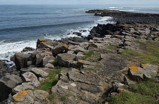
Je loopt over zandstranden, coastal rock
(abrasieplatform, brandingsterras),
paden door duinen
en boven over lage kliffen.
Op je Harvey-strookkaart zie je afwisselend zandstrand (oranje) en coastal
rock (donkergrijs).
(Coastal rock is het brandingsplatform)
Zie voor een goede introductie van de verschillende kustvormen:
engeland_coastal-landscapes
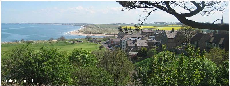
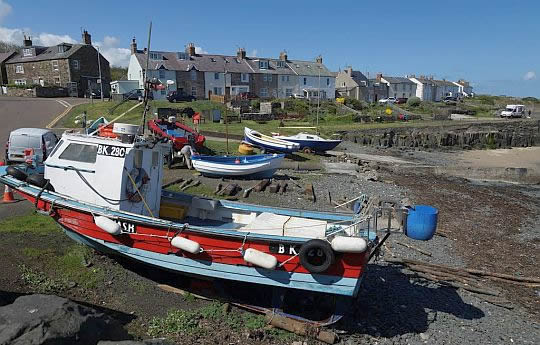
• Low Newton-by-the-Sea.
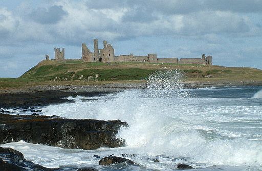
• In de verte ruined castle Dunstanburgh, standing upon its remote headland
overlooking the North Sea.
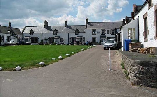
• The lovely fishing hamlet of Low Newton with a square of whitewashed cottages.
Routemarkering:
Zeer goed, zoals gebruikelijk bij "national trails".
Bevoorrading:
• Levensmiddelen: Er zijn voldoende dorpjes met een kruidenier.
Zie het weegschaal-symbooltje op je Harvey - strookkaart.
(Let op: Bamburgh heeft er géén !)
• Drinkwater: Er zijn voldoende dorpjes/huizen onderweg.
ANWB Campings:
Zie voor een overzicht anwb.nl/engeland
Wildkamperen (bivak):
Gaf mij geen problemen.
Hoogtepunten:
• Bamburgh Castle : ruined castle restored as a fantasy castle,
• Low Newton-by-the-Sea, (fishing hamlet),
• Dunstanburgh Castle perched on a promontory (vooruitspringende rots),
• Alnmouth,
• Warkworth with Warkworth Castle.
This fortified village has a well-preserved old centre enclosed (ingesloten)within a meander of the river Coquet, with Castle Street running downhill
from the castle to the
market square.
Public transport:
http://traveline.info/
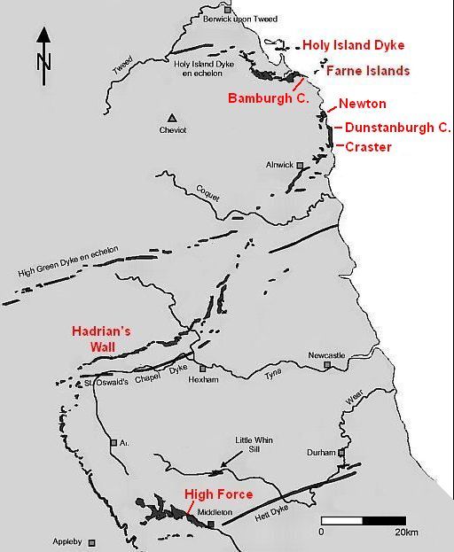
Whin Sill:
Een van de meest opmerkelijke dingen aan deze kust is het voorkomen van
de
zogenaamde Whin Sill.
Het is een hard, donker stollingsgesteente (basalt) dat moeilijk verweert.
Het is de oorzaak van de ligging van Bamburgh Castle en de Farne Islands.
Ook verder zuidwaarts tot aan Alnwick is de Whin Sill steeds in de rotspunten
langs de kust aanwezig (dus ook bij Dunstanburgh Castle ).
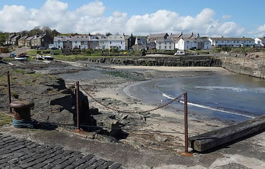
• Craster Harbour.
• Craster Harbour.
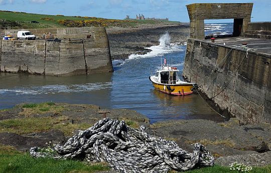
• Kijkend vanuit Craster Harbour noordwaarts over de rocky shoreline naar ruined castle Dunstanburgh in de verte.
Eindbeoordeling:
Het deeltraject Beadnell - Alnmouth heeft top trail - kwaliteit.
Beste websites:
www.northumberland.g...
........................................
www.contours.co.uk/w...
Sites komen en gaan; dat valt niet bij te houden.
Googel daarom ook een keer naar northumberland coast path tours en
bekijk
de eerste 10 (evt. 20)
resultaten.
Daar zitten de belangrijkste sites
wel tussen.
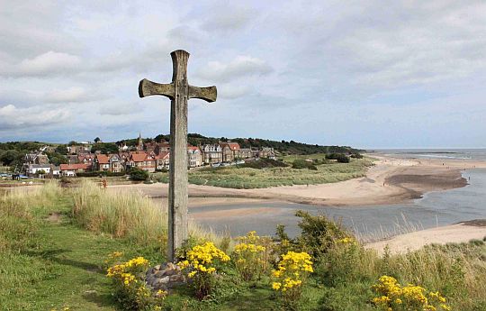
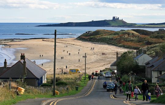
• The village Alnmouth seen from across the River Aln from Church Hill.
• Alnmouth with its beautiful beach and rich history, makes for a pleasant stop on the
coastal walk, but the wide and fast-flowing River Aln entails a diversion inland.
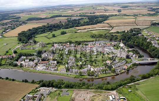
• The village Warkworth is situated in a loop of the River Coquet.
• It is probably best known for its well-preserved medieval castle, church and hermitage.
| aaaa |
Korte beschrijving van de tweedaagse wandeltrektocht:
Day 1. Bamburgh — Craster
22 ½ km......Lichte wandeling
.
- Bamburgh was the site of King Oswald's royal seat.
- It is now dominated by one of Northumberland's most familiar landmarks, the imposing Bamburgh Castle (ruined castle restored as a fantasy castle).
Perched on an outcrop (ontsluiting) over the village, Bamburgh Castle
offers wonderful views of the coastline below and of the Farne Islands (bird sanctuaries and seal colonies).
- From here, the trail heads towards the popular seaside village of Seahouses.
- The route then follows the coast southwards past Beadnell to the beautifully
preserved small fishing hamlet of Low Newton-by-the-Sea.
- After this the trail passes the romantic ruined castle Dunstanburgh, sitting on a rocky headland,
before arriving at the charming fishing village of Craster.
Day 2. Craster — Warkworth
19 km ....Lichte wandeling
.
- From Craster the trail continues southwards down the coast.
- It passes the site of Northumberland's earliest Stone Age Settlement Howick hillfort (= hillfort ; walburcht), before arriving at the village
of. Boulmer with the nearby Royal Air Force base.
- After heading through the picturesque village of Alnmouth, the routepasses around the Aln Estuary before using paths through the coastaldunes with splendid views of Amble and Coquet Island.
- The trail then meets the River Coquet at the historic village Warkworth, with its impressive ruined castle Warkworth and medieval fortified
bridge.
Verderop bij Van dag tot dag geef ik een uitgebreidere beschrijving.
| aaaa |
Bamburgh Castle
(ruined castle restored as a fantasy castle)
• Bamburgh Castle is visible from land or sea for miles along the coast.
• The site was originally chosen by the sixth-century kings of Northumbria for its commanding possition and the fact that it had a natural harbour.
• The first castle was destroyed in Viking raids but the location was too good
to leave to nature. Within fifty years of the Conquest those prodigious castlebuilders the Normans had produced another formidable fortified castle that stood until the end of the Wars of Roses.
• The fate of Bamburgh seemed sealed with the invention of the cannon, and it fell into disrepair. Its final abandonment by James I reflected the decline in fortunes of the northeast coast at the beginning of the seventeenth century as the political importance of the border regions ebbed away.
• However, Bamburgh was restored by the nineteenth-century industrialist
Lord Armstong as a fantasy castle, which explains why it looks for all the
world like Lancelot's Camelot.
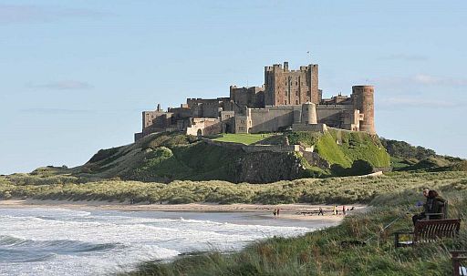
• Op deze foto zie je wat we bedoelen met:
Northumberland coast is sandy beaches and imposing castles.
• Bamburgh Castle is op een rotspunt van de Whin Sill gebouwd.
• Few castles can rival the setting of Bamburgh on the Northumberland coastline.
It dominates the coast from its craggy hill (= rotsige heuvel).
• The Whin Sill was formed when layers of magma were forced into horizontal beds of
sedimentary rock. Subsequent wheathering and erosion resulted in the present land scape, with outcrops (ontsluitingen) of Whin Sill.
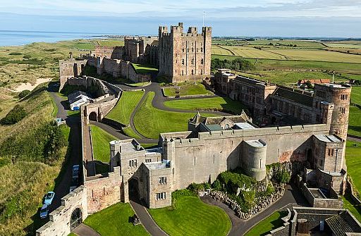
• The full might of Bamburgh Castle on its massive basalt outcrop (ontsluiting) is shown in this aerial view.
| aaaa |
Ruined castle Dunstanburgh:
Ruined castle Dunstanburgh is an archetypal mediaeval castle dominating a headland. It was once one of the largest castles in the north-east
of England.
Much of the castle lies in ruins, derelict and neglected since its decline
in
the fifteenth century.
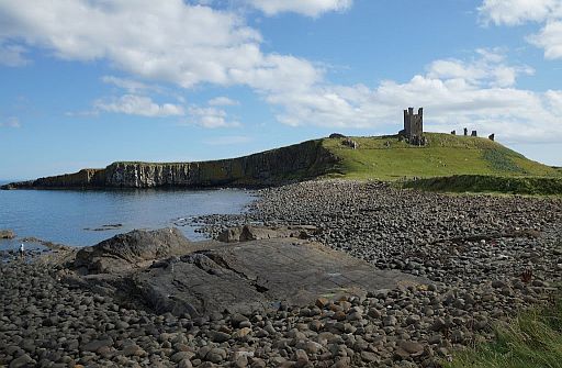
• Ruined castle Dunstanburgh, perched on a promontory (vooruitspringende rots) formed by a black basalt outcrop (ontsluiting), known as the Whin Sill.
• Je kijkt vanuit het noordwesten naar de kasteelruine.
• Nu gezien vanuit het zuiden.
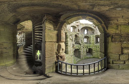
• Inside the ruins.
| aaaa |
Whin Sill:
The Whin Sill is one of the special geological features of the North
East England and forms some of the area's most dramatic landscapes.
Molten origins:
The hard, dark rock of the Whin Sill was once molten, but now stands
out
as spectacular craggy hills or cliffs.
The Whin Sill formed 295 million years ago when stretching of the
Earth's
crust caused molten rock, or magma, at over 1000 °C to rise up through
cracks in the rock
from
deep within the Earth.
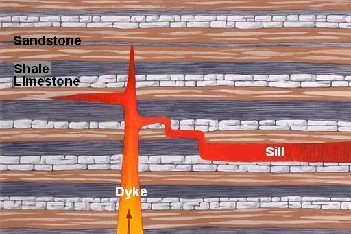
It didn't reach the surface but was injected between layers of sedimentary
rock (=sedimentgesteenten) (limestone, shale and sandstone).
The magma cooled and solidified underground to form the Whin Sill –
a vast sheet (=plaat) of rock up to 60m thick, which lies beneath much
of North East England.
It is made of a hard dark igneous rock (=stollingsgesteente) and is much tougher than
the sedimentary rocks (=sedimentgesteenten) around.
After millions of years of erosion the Whin Sill is now partly exposed
at
the
surface as craggy hills or cliffs.
...Igneous rocks (=stollingsgesteenten) Sedimentary rocks (=sedimentgesteenten) |
Dykes (= gangen) en sills:
.
• Dykes (=gangen)
They are formed as magma pushes up towards the surface through cracks in the rock and harden there.
They form vertical or steeply-dipping (steil hellende) sheets (platen) (wall-like bodies)
of igneous rock (stollingsgesteente).
.
• Sills (= sills; intrusie-platen)
They are formed when magma intrudes (indringt) between the rock
layers and harden there.
They form horizontal or gently-dipping (flauw hellende) sheets (platen) of igneous rock (=stollingsgesteente).
Crystals and columns:
The Whin Sill is made of a hard, dark, crystalline rock (een basalt).
As it slowly cooled, the Whin Sill contracted (kromp) , producing vertical cracks (scheuren) along which the rock breaks into rough columns (zuilen) (see picture below).
This is a distinctive feature of most Whin Sill outcrops (ontsluitingen).
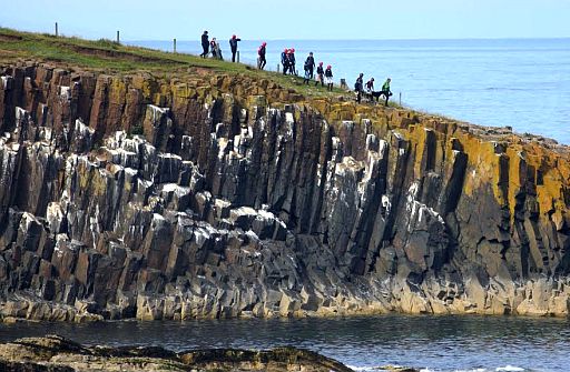
• Bij krimp, na stolling, van afkoelende vulkanische gesteentemassa's vormen zich vaak zuilen, meest 6-zijdige, ook wel 4-,5-, 7-, of 8-zijdige.
• Cullernose Point is formed from the Whin Sill.
• The Whin Sill probably took
around 50 years to cool from
molten rock to solid dolerite (dit is een basalt).
During the cooling (afkoeling) it contracted (=kromp) , producing vertical
cracks (scheuren) along which the rock breaks into rough columns (zuilen).
You
can see these cracks and columns in the cliff.
• During the summer months, the cliffs are home to kittiwakes (Drieteenmeeuwen) and fulmars (Noordse Stormvogels).
• Newton Point another example of Whin Sill.
• Hier zie je de krimpscheuren door de langzame afkoeling van een basaltlava.
The original sill:
The name 'Whin Sill' was first used by local quarrymen.
To them 'whin' was a hard, dark rock, and
'sill' was a term for a flat-lying layer of rock.
Geologists who studied the Whin Sill in the 19th century recognised its molten origins and the term 'sill' was adopted for all similar bodies of igneous rock(=stollingsgesteente).
The Whin Sill is thus the original sill of geological science and is well
known to geologists worldwide.
| aaaa |
Where to see the Whin Sill:
.
• The Whin Sill extends over a large area from Middleton in Teesdale
in the south to Berwick in the north.
• It varies from 30 m to about 60 m in thickness, and gradually thins as
it goes westwards.
• However, in most places the sill of dolerite is not seen on the surface .of the ground, but remains covered by the carboniferous rocks.
• Only in a few areas it has been exposed by the erosion of overlying .rocks.
In that case, the hard, dark-coloured dolerite, which is very resistant
to erosion, stands out as craggy hills or cliffs in the landscape.
• Because of its resistance to erosion this dolerite, forms:
- islands: e.g. Farne Islands,
- ridges: e.g. Hadrian's Wall,
- waterfalls e.g. High Force.
- the base for castles: e.g.
. Bamburgh Castle,. Dunstanburgh Castle and. Castle on Holy Island (The last one is not sited on a sill but a dyke).
| . Situeringskaart Whin Sill ( Dolerite ) ontsluitingen: |
.
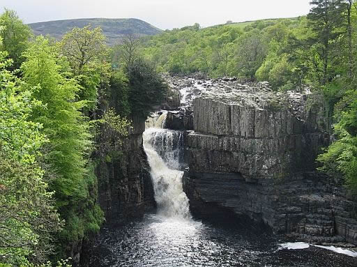
• The Whin Sill is also responsible for one of Britain’s most famous waterfalls: High Force.
Here the River Tees falls more than 20 m over the resistant rocks of the Whin Sill.
• Two types of rock can be seen at the falls:
- The lower rocks are horizontal sediment layers.
- The upper rocks are dark dolerite and has vertical joints.
They are much harder than the sediment layers underneath.
• This tough dolerite is resistant to erosion, which explains the location of the waterfall.
Where there is no dolerite, the valley broadens out and waterfalls are absent, but other bands of dolerite create waterfalls just a short distance upstream at Cauldron Snout and downstream at Low Force.
| aaaa |
Van dag tot dag volgens
www.contours.co.uk/walking...
Day 1. Bamburgh — Craster
22 ½ km ......lichte wandeling
- Bekijk Bamburgh met kasteel.
- loop daarna via het strand (of door de weilanden) naar Seahouses.
Je kunt ten noorden van het kasteel via de parkeerplaats het strand op.
- Loop ook van Seahouses naar Beadnell waar mogelijk over het strand.
- Vervolgens van Beadnell verder over het strand tot aan de monding van de Long Nanny Burn. (Je omzeilt op deze manier een grote, lelijke caravan site).
Ga bij de beekmonding enkele honderden meters landinwaarts naar het voetbruggetje en verder over paden tot aan Craster. .
- Bamburgh was the site of King Oswald's royal seat.
- It is now dominated by one of Northumberland's most familiar landmarks, the magnificent Bamburgh Castle ( a ruined castle restored as a fantasy castle).
Perched (= zittend) on an outcrop (ontsluiting) over the village, the imposing Bamburgh Castle offers wonderful views of the coastline below
and of the Farne Islands (bird sanctuaries and seal colonies).
- From here, the trail heads towards the popular seaside village of Seahouses.
- The route then follows the coast southwards past Beadnell Bay (which in summer is home to a large colony of arctic terns) and further
to the picturesque hamlet square of Low Newton-by-the-Sea.
- At Newton Pool nature reserve are
two wildlife hides that face out over the waters.
- After this the trail passes the romantic ruined castle Dunstanburgh, follows. the rocky shoreline and arrives at the charming fishing village of Craster.
Day 2. Craster — Warkworth
19 km......lichte wandeling
- From Craster the trail continues southwards down the coast.
- It passes the site of Northumberland's earliest Stone Age Settlement Howick Hillfort(= hillfort; walburcht) before arriving at the village of Boulmer, with the nearby Royal Air Force base.
- As you head towards Alnmouth, the beautiful beach can be used as analternative to the path just inland of the dunes, which passes two golfcourses.
- After heading through the picturesque village of Alnmouth, the route passes around the Aln Estuary before using paths through the coastal dunes with splendid views of Amble and Coquet Island.
- The trail then meets the River Coquet at the historic village Warkworth, with its impressive ruined castle Warkworth and medieval fortified bridge. A fine conclusion to this short break.
| aaaa |
SNP Natuurreizen heeft in Groot-Brittanië ook wandelreizen:
Hun reizen met een zwaarte van 1 of 2 zwarte cirkeltjes komen het beste overeen met mijn wandelingen.
Je maakt dan niet te veel hoogtemeters en wandeluren per dag.
Zie: www.snp.nl/reizen/
| aaaa |
... Wandelgidsjes + boek met achtergrondinfo:
..
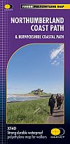
2. Northumberland Coast Path Voor een boek met achtergrondinfo: Strookkaart: Harvey strip maps (strookkaarten) zijn de beste
kaarten. Te bestellen bij: Reisboekwinkel de Zwerver ( webshop voor reisgidsen en landkaarten) ..... |
..Deze wandelsite is niet-commercieel, onafhankelijk en gratis. Dat is enkel mogelijk door steun van de bezoekers. Uiteraard kun je ook doneren door overschrijving op mijn |
Weet je aanvullingen en verbeteringen van deze tekst?
Graag een e-mail naar:
![]()
![]() ....
.... ![]() ....
....![]()
LAATST BIJGEWERKT : 7-1-2019