...
..MOOISTE. KUSTWANDELINGEN
............... ENGELAND
.......... ( weekendwandelingen )
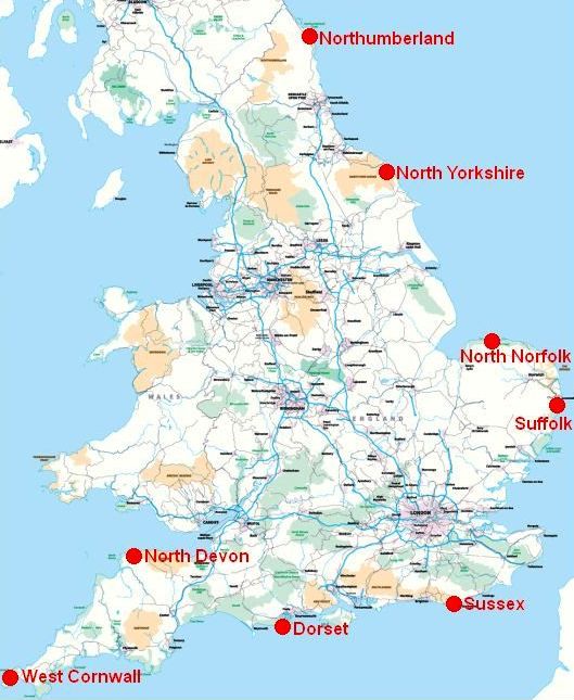
Snel naar een regio:
(door klikken op een naam)
De meeste wandelingen zijn in belangrijke natuurgebieden. Denk aan:
1. National Park (= lichtbruin) of
2. AONB(Area of Outstanding Natural Beauty) (=lichtgroen) (This is the next step down from a National Park)..
| aaaa |
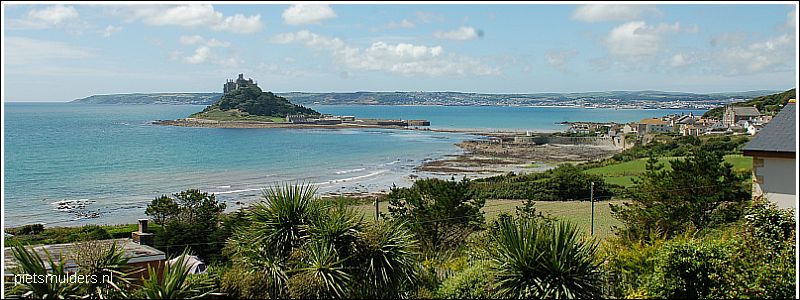
WestCornwall
WEST CORNWALL:
(Walking to the tip of Britain)
Porthcurno – St Ives
48 km .. .. 3 dagen
Topper onder de kustwandelingen:
Zie: Top 10 UK coastal walks.
Terrein:
Dramatic and frequently challenging cliff path,
with some steep climbs and rough ground,
particularly in the last third of the route.
Introductie:
• The Land's End peninsula is a singularly special place: soaring cliffs and headlands (=kapen), exquisite sandy bays and the Atlantic Ocean crashing into the rocks at your feet.
• Derelict tin mine workings cling to the cliff edge, and there is a profusion
of flowers and migrant birds.
• Early in the walk you'll pass the Minack Theatre, an open-air amphitheatre fashioned out of the cliffs in the 1930s;
the tiny but stunning sandy cove of Porth Chapel; and Porthgwarra, a tiny fishing village.
• Then the coast path takes off on an exhilarating, challenging clifftop journey
to Land's End.
• From there, break the long walk to St Ives with overnight stays in St Just and Zennor.
Verdere informatie (wandelgids, kaart, etc.):
engeland_westcornwall.html
Zie voor een goede introductie van de verschillende kustvormen:
engeland_coastal-lands...
ANWB Campings:
Zie voor een overzicht anwb.nl/engeland
Wildkamperen (bivak):
Gaf mij geen problemen.
.
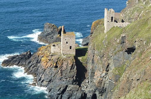
• The disused tin mines at Botallack Head cling to the very cliff edge.
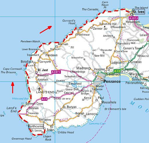
streetmap.co.uk
| aaaa |
NorthDevon
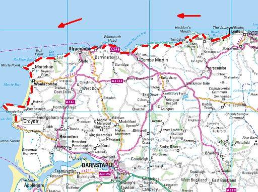
NORTH DEVON:
(Exmoor's Wild coast)
Lynton – Croyde
50 km .. ..2-3 dagen
.
Topper onder de kustwandelingen:
Zie: Top 10 UK coastal walks.
Terrein:
Undulating and sometimes steep coastal path embracing
open
clifftop and rocky headlands, sheltered bays and woodland.
Introductie:
• This section of the North Devon coast is stimulating but rigorous: it includes the highest spot on the South West Coast Path: Great Hangman.
• There are also delightful pockets of woodland and numerous bays and
coves, plus the traditional seaside resort of Ilfracombe.
• Lynton is a small, interesting clifftop town separated from its village neighbour, Lynmouth, by a 150m drop. A water-powered cliff railway(pictured) connects them.
• The undulating and sometimes steep coastal path featuressuperb views across to the Gower peninsula and South Wales, and also swings inland to
the Valley of Rocks, a curious dry valley encircled by jagged tors with its
own herd of free-ranging goats.
Verdere informatie (wandelgids, kaart, etc.):
engeland_exmoor-swcp.html
Zie voor een goede introductie van de verschillende kustvormen:
engeland_coastal-lands...
ANWB Campings:
Zie voor een overzicht anwb.nl/engeland
Wildkamperen (bivak):
Gaf mij geen problemen.
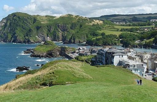
• Ilfracombe: view from Capstone Point showing the entrance to the harbour.
• Het grootste deel van Ilfracombe ligt rechts van de foto in een beschutte inham omgeven. door heuvels.
 streetmap.co.uk
| aaaa |
Dorset
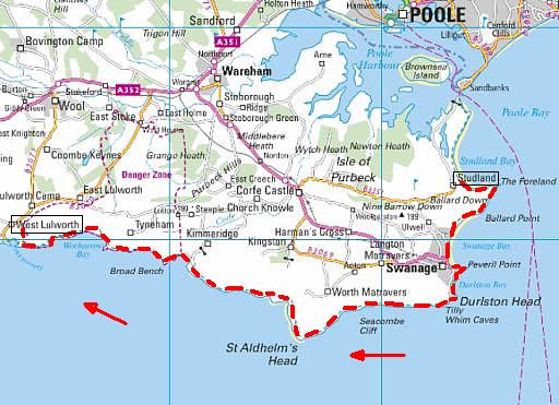
DORSET: .
(The Jurassic Coast).
Studland – Lulworth Cove
38 km .. ..2 dagen
.
Topper onder de kustwandelingen:
Zie: Top 10 UK coastal walks.
Terrein:
Grassy cliff path, promenade and sandy bays.
Be aware that there are
some very steep sections approaching Lulworth,
with plenty .of ascent..
Introductie:
• The Dorset coast offers extremes: from safe, sandy beaches to plunging
cliff paths.
• The Dorset and East Devon Coast was England's first natural world heritage site, and it is said that in 95 miles you can walk through 185 million years of history in just one week.
• The Studland Heath nation... is an important area of dunes
and heathland that supports threatened species such as the nightjar (= Nachtzwaluw), ladybird spider and sand lizard.
• This short but rewarding excursion encompasses part of the South West Coast Path, along grassy cliff paths, promenades and sandy bays;
there are some
very steep sections.
• Look out for the dramatic Old Harry and Durdle Door rocks, St Aldhelm's Norman chapel and bottlenose dolphins.
Verdere informatie:
engeland_jurassiccoast.html
Zie voor een goede introductie van de verschillende kustvormen:
engeland_coastal-lands...
ANWB Campings:
Zie voor een overzicht anwb.nl/engeland
Wildkamperen (bivak):
Gaf mij geen problemen.
.
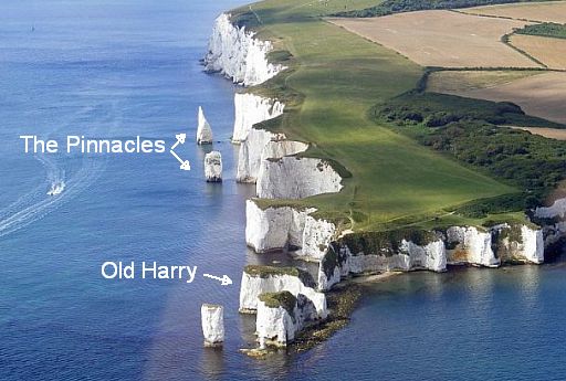
• Chalk cliffs and stacks at Handfast Point.
• Chalk (= krijt) is generally considered a soft rock, but it is surprisingly resistant to marine erosion and
forms towering vertical cliffs along the coast.
• The string of sea stacks (= brandingspilaren) that trail out onto the sea off the point here formed after the last age.
• Sea stacks like Old Harry form when slightly harder areas of rock resist erosion whilst everything else around them is worn away. Eventually these stacks will collapse but
new ones will replace them. Ongoing erosion like this is the main reason the coast is
so beautiful.
streetmap.co.uk
| aaaa |
Sussex
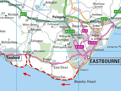
SUSSEX:
(A Chalkland Rollercoaster).
Eastbourne – Seaford
22 ½ km ....1-2 dagen
.
Topper onder de kustwandelingen:
Zie: Top 10 UK coastal walks.
Terrein:
Springy turf and wellwalked paths
along undulating chalk cliffs and
valley bottom.
Introductie:
• Eastbourne is an extremely civilised beginning to one of the UK's classic coast walks.
• The billowing chalk downland of Beachy Head and the Seven Sistersare
popular spots for walkers so it's unlikely you'll have them to yourself, but
this is a sociable (as well as energetic) coast walk, full of grand views and
items of interest.
• You will be following the last stage of the South Downs Way along undulating chalk cliffs and valley bottoms.
Verdere informatie:
engeland_southdownsway.html
Zie voor een goede introductie van de verschillende kustvormen:
engeland_coastal-lands...
ANWB Campings:
Zie voor een overzicht anwb.nl/engeland
Wildkamperen (bivak):
Gaf mij geen problemen.
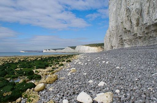
• De Seven sisters in de verte, gezien vanaf het rolsteenstrand. De golvende krijtheuvels zijn kaarsrecht afgesneden door de zee.
• Rechts zie je een brandingsnis. Ze ligt ongeveer op hoogwaterniveau.
• Ervoor ligt een grijze wal van vuursteen-rolstenen met hier en daar een brok krijt).
(The grey cobble beach is of rounded flint nodules, speckled with fresher chalk lumps.) Hun ronde vorm kregen de rolstenen bij het heen en
weer rollen door de golfslag.
• Links het wave-cut platform (= brandingsplatform)
streetmap.co.uk
| aaaa |
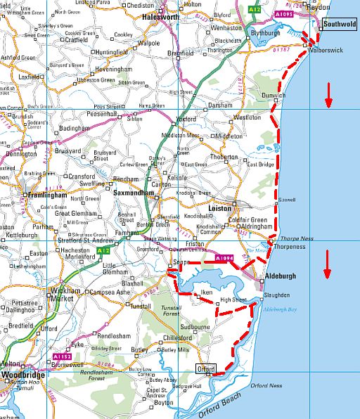
Suffolk
SUFFOLK: .
(Resisting the Tide).
Southwold – Orford
48 km .. ..2 dagen
.
Terrein:
Low, flat shoreline of shingle bank, dunes, heathland tracks and grassy embankment.
Introductie:
• The Suffolk Coast & Heaths AONB contains iconic coastal landscapes including the largest shingle spit (kiezel-schoorwal) in Europe – Orford Ness and the great sweeping sandy beaches of Dunwich Heath.
The elegant towns of Southwold and Aldeburgh appear to actively resist
the excesses of the modern seaside resort, while an out-of-season walk through villages such as Orford and Walberswick feels like a journey
back into the
past.
• The landscape, too, can be tremendously evocative, especially when the
mist is swirling over the marshes and feeling its way up the rivers and
estuaries that bite into the low-lying country.
From shingle(= kiezel) and reedbed to heath and woodland, the
Suffolk
coast is surprisingly varied, and since much is protected by a
string of nationally important nature reserves, it makes for a great
wildlife walk.
Verdere informatie:
www.cicerone.co.uk/...
Zie voor een goede introductie van de verschillende kustvormen:
engeland_coastal-lands...
ANWB Campings:
Zie voor een overzicht anwb.nl/engeland
Wildkamperen (bivak):
Gaf mij geen problemen.
• Aldeburgh's shingle (= kiezel) shoreline.
streetmap.co.uk
| aaaa |
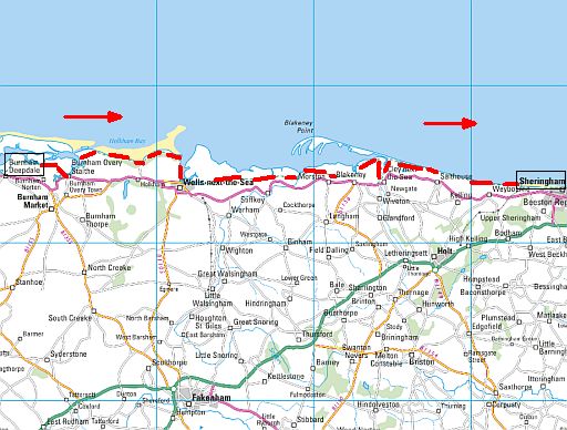
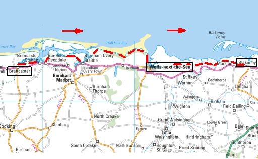
NorthNorfolk
NORTH NORFOLK:
(From Seals to Saltmarsh).
Burnham Deepdale – Sheringham
47½ km .... ..2 dagen
.
Topper onder de kustwandelingen:
Zie: Top 10 UK coastal walks.
Terrein:
Easy, flat edge of saltmarsh and top of sea banks ;
low, grassy clifftop ; shingle and sand dunes.
Introductie:
• Along the wild and atmospheric Norfolk shores are vast tracts of tidal saltmarshes (=kwelders) and mudflats (=wadden) , riddled with creeks
and inlets.
There are also glorious sandy beaches and dunes, low, crumbling cliffs and constantly shifting shingle banks.
• The emphasis is not on the challenging ups and downs of many coastal routes, but on the AONB (Area of Outstanding Natural Beauty) that
stretches the whole way along the trail.
• Here golden sands, salt marshes and pine woodland combines perfectly
with the charming tile and flint cottages along the trail.
• A particular highlight is the glorious golden beach at Holkham Bay.
• The nature reserve at Blakeney Point also offers the chance to see one
of the largest colonies of common and grey seals.
Verdere informatie Norfolk Coast Path:
engeland_norfolkcoastpath.html
Zie voor een goede introductie van de verschillende kustvormen:
engeland_coastal-lands...
ANWB Campings:
Zie voor een overzicht anwb.nl/engeland
Wildkamperen (bivak):
Gaf mij geen problemen.
.
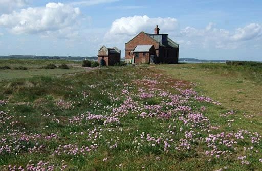
• Blakeney Point, the watch house.
streetmap.co.uk
streetmap.co.uk
Voorstel van contours.co.uk:
1. Brancaster (T) ― Wells-next-the-Sea ........... 19 km
2. Wells-next-the-Sea ― Blakeney .................. 13 km
(Travel to Wells-next-the-Sea and book there your accommodation)
Zie: www.contours.co.uk/... .... ....
| aaaa |
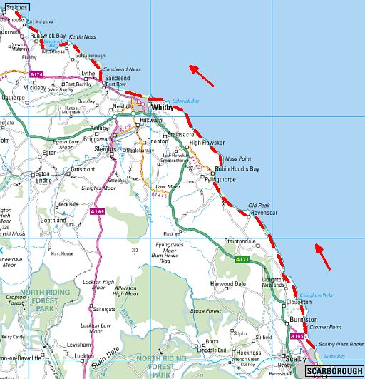
NorthYorkshire
NORTH YORKSHIRE:.
(Northern Rock).
Scarborough – Staithes
51½ km .. .. 3 dagen
.
Topper onder de kustwandelingen:
Zie: Top 10 UK coastal walks.
Terrein:
High-level cliff paths, sometimes slippery when wet,
with occasional steep flights of steps; plus beach and promenade sections.
Introductie:
• It's quite a challenging walk along this stunning bit of Yorkshire coast, with high-level cliff paths, steep flights of steps and areas of cliff erosion.
• Starting in Scarborough, you head north past the elegant old guest houses and climb the coast path, the Cleveland Way.
Grassy farmland and old coastguard lookouts set the scene, and places to visit on the way include:
the Ravenscar estate,
a mill-turned youth hostel at Boggle Hole (yha.org.uk/hostel/boggle-hole ), Robin Hood's Bay and Whitby's spooky attractions.
Sandsend is a glorious stretch of sandy beach, then after a couple more villages you reach lovely Staithes, full of pretty fishing cottages.
Verdere informatie:
engeland_cleveland...(voor het noordelijke deel)
nationaltrail.co.uk/c...
Zie voor een goede introductie van de verschillende kustvormen:
engeland_coastal-lands...
ANWB Campings:
Zie voor een overzicht anwb.nl/engeland
Wildkamperen (bivak):
Gaf mij geen problemen.
.
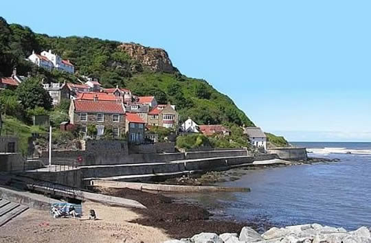
• The houses of Runswick Bay cling to the hillside at the northern end of a curved bay.
• Runswick Bay has the only stretch of sand along this part if the coast.
streetmap.co.uk
| aaaa |
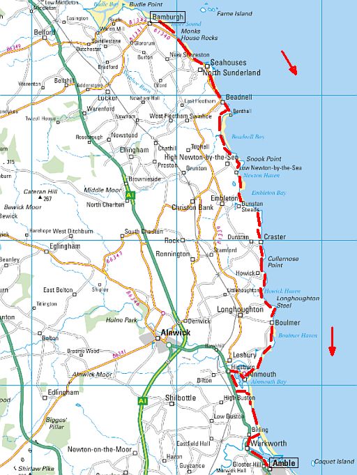
rthumberland
NORTHUMBERLAND:
(A Coast of Castles)
Bamburgh – Amble
43 km .. .. 2 dagen
.
Terrein:
Easy sandy beaches, plus paths through dunes and along rocky foreshore.
Introductie:
• Deserted sandy beaches and imposing castles characterize the Northumberland coast.
• It's a low and open shoreline of unblemished golden strips and gentle, yawning bays.
• There's a
scattering of fishing villages, some generally low-key tourism and, of course , a succession of impressive fortifications in various stages of repair.
• But despite its obvious beauty, this is the coast that always seems to have space aplenty. There may be queues for the causeway toHoly Island, and the master fryer at the fish and chip shop in Seahouses can be working up a sweat, but out on the beaches you can usually walk in space and freedom, enjoying the stunning seascapes and rich variety of wildlife.
Verdere informatie:
engeland_northumberl...
Zie voor een goede introductie van de verschillende kustvormen:
engeland_coastal-lands...
ANWB Campings:
Zie voor een overzicht anwb.nl/engeland
Wildkamperen (bivak):
Gaf mij geen problemen.
.
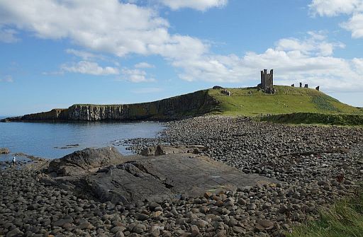
• ruined castle Dunstanburgh, perched on a promontory (vooruitspringende rots).formed by a black basalt outcrop (ontsluiting), known as the Whin Sill.
• Je kijkt vanuit het noordwesten naar de kasteelruine.
streetmap.co.uk
| aaaa |
The National Trust is our biggest coastal landowner

In the summer of 1965, a young geography professor called John
Whittow
and a few dozen students set out for a walk along the shores
which would
change the character of the coast forever.
They spent their holiday forcing their way through bramble thickets,
hurdling barbed wire and jumping streams to survey on foot every mile
of the coast of England, Wales and Northern Ireland, concluding that a
third of this uniquely varied 3,000-mile coastline was pristine, precious
and worth preserving.
Their findings kick-started Enterprise Neptune, a fundraising campaign
for the National Trust which after half a century has saved 742 miles of
beach, cliff, estuary and bay from development or destruction.
| aaaa |
... Boeken met informatie: Coastal Walks Around Britain, In 2011 is Coastal Walks Around Britain met wat kleine wijzigingen
opnieuw uitgebracht,
maar nu onder de titel: • Deze twee boeken zijn alleen nog antiquariatisch te krijgen. |
..Deze wandelsite is niet-commercieel, onafhankelijk en gratis. Dat is enkel mogelijk door steun van de bezoekers. Uiteraard kun je ook doneren door overschrijving op mijn |
Weet je aanvullingen en verbeteringen van deze tekst?
Graag een e-mail naar:
![]()
..![]() ....
.... ![]() ...
...![]()
LAATST BIJGEWERKT : 7-1-2019