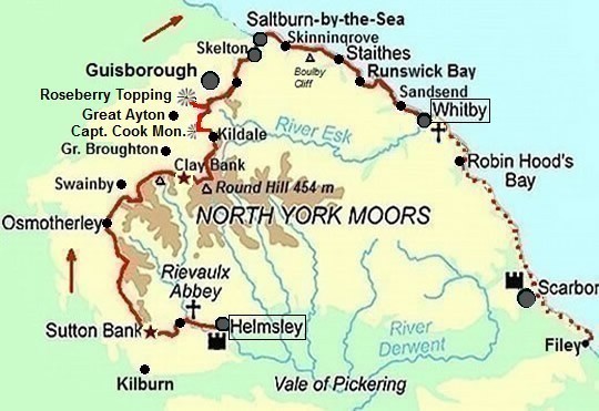
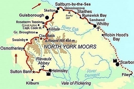
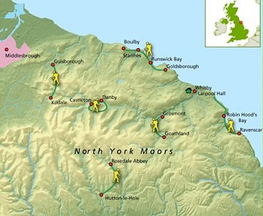
..........CLEVELAND WAY
...... Helmsley – Whitby = 125 km
.
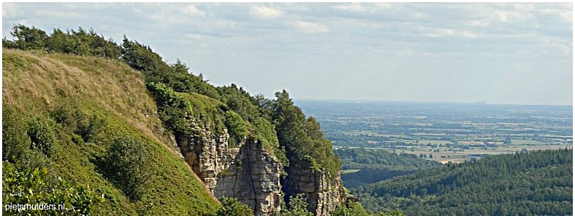
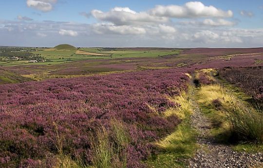
North York Moors : gentle rolling heather-clad moorlands. .
• The North York moors National Park is a plateau with west-facing escarpment (=cuestafront).
• Deze hoogvlakte ligt 300 tot 400 m
boven haar omgeving
(die slechts een
beetje boven zeeniveau ligt).
De North York Moors rekenen we nog tot de uplands (Upland = all land above the upper
limit of enclosured (=omheind) farmland.Dit is grofweg het gebied hoger dan 1,000 feet
(ongeveer 300 m).
• Haar flat-topped hills zijn glooiend en zwak aflopend naar het
zuiden. (het gebied is een cuesta; zie verderop) Het kent weinig
rotspartijen.
| . LAND USE. in. NORTH YORK MOORS NATIONAL PARK |
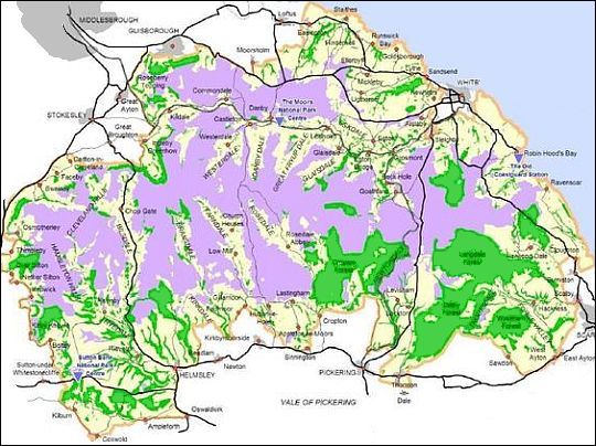
• Paars = Moors (... • Groen = Plantation/ Woodland (...• Geel = Farmland
Moors, dales and coast:
These are the three basic elements:
.
1. The Moors(=venen) :
- Gentle rolling heather-clad moorlands (zacht golvend heideveen).
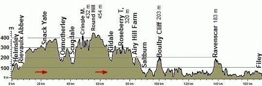
- The moorland plateau is not exceptionally high. The park reaches its highest point on Round Hill (454 m).
- The plateau has the largest expanse of upland heath in England, but bogland is limited. (The rainfall on the north-east moorlands is considerably less than that on the high Pennines some 40 km to the west.)
- Space and solitude characterise these moors. And while many walkers believe it is. a wilderness landscape, the expanse of heather is in fact entirely man-managed to provide a favourable habitat for red grouse (which are preserved for hunting).
.
2. The Dales:
- From the main moorland watershed radiate a series of lush green dales.
- These valleys shelter farms and small villages, plus abbey and castle ruins.
- Here and there on the sides of the dales is a mixture of indigenous trees - a reminder of the type of woodland that once covered much of the plateau. However plantations dominate the scene in terms of area.
.
3. The Coast:
- The coastline is a range of generally high cliffs with intervening wooded, coastal gorges.
Het hoogste klif is hier Boulby Cliff (203 m) (zie ook hoogteprofiel verderop). (Dit is tevens het hoogste klif aan de oostkust van Engeland.
-. Een mooi voorbeeld van een beboste kustkloof is de wooded gully of Claymore. Beck (Kijk bij Runswick Bay op je Harvey-strookkaart.)
De Cleveland Way loopt er doorheen. Men heeft daar in de kloof een touw gespannen en een trap gemaakt. Hierover klim je 100 hoogtemeter naar de kliftop. In het bovenste deel van de kloof zie je mooi bos/struweel.
- Most of the coast has a wave-cut platform (=brandingsplatform) (in je Harvey-strookkaart wordt dat in de legenda coastal rock genoemd en is donkergrijs).
- Only some of the bays have sandy beaches.(in de Harvey-kaart: oranje gekleurd).
| . RELIEFKAART VAN HET NORTH YORK MOORS NATIONAL PARK |
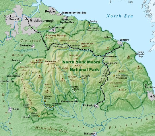
• From the main moorland watershed radiate a series of lush green dales.
• De donkergroene lijn en de kustlijn vormen de grens van het Nationale Park.
• De rode lijn is de Cleveland Way.
De Cleveland Way: heather moorland (=heideveen) en hoge klifkust.
Het is een hoefijzervormige meerdaagse route rond het North York Moors-plateau. Daarbij loop je eerst bovenlangs de westelijke escarpment (=cuestafront) van het plateau, en vervolgens bovenlangs de kliffen aan de Noordzeekust.
• Bij de South Downs is er echt sprake van een asymmetrische heuvelrug.
Bij zowel de Cotswold Hills als de North York Moors heeft de dip slope van de cuesta echter meer weg van een plateau dan van een rug.
The more massive limestones in the North York Moors give rise to 300-metre escarpments (=cuestafronten), yet the dip slope is frequently of such a low angle that the countryside resembles a dissected plateau (plateau doorsneden door rivierdalen), passing gradually on to the clay vales.
.
1. Bovenlangs de westelijke escarpment (=cuestafront):
Hier is aan uitzichtpunten geen gebrek.
Westwaarts kijk je voortdurend over de enkele honderden meters lager gelegen agrarische vlakte en oostwaarts over het zacht golvende heather moorland (heideveen).
Dit gedeelte van de wandeltrektocht is dus een écht panoramapad.
.
2. Bovenlangs de kliftoppen aan de kust:
- De kust heeft hoge kliffen onderbroken door coastal ravines. (deep, steep-sided, wooded ravines leading down to the sea).
- Deze kustkloven zijn ontstaan door het diep insnijden van beekjes en riviertjes.
- Deze kloven dwingen je telkens tot een afdaling, gevolgd door een klim.
- In de grotere kustkloven liggen dikwijls badplaatsen en vissersdorpen.
Voorbeelden van schilderachtige vissersdorpen zijn Staithes en Runswick Bay.
Naamsverklaring Cleveland Way:
The Cleveland Way is named after the county of Cleveland, but in fact is mostly based the North Yorkshire Moors National Park.
| .. MOOISTE DEEL :.. HELMSLEY – WHITBY |
 • Deze route kent zeer veel uitzichtpunten.
• Alleen de 2 belangrijkste zijn in de kaart met een uitzichtpunt-symbooltje aangegeven. Het zijn . Captain Cook Monument .en .. Roseberry Topping.
Fotoalbum:
https://picasaweb.google.com/
Introductie:
http://walkeast.org/resources/
Mooiste deel:
Van Helmsley naar Whitby.
Voor de kilometers ten zuiden van Whitby geldt:
• Het traject Whitby ― Robin Hood's Bay is ronduit zwak.
• Robin Hood's Bay zélf is heel schilderachtig en romantisch, maar daar kom je ook al tijdens de Coast to Coast Walk.
• Na Robin Hood's Bay wisselen goede en zwakke gedeelten elkaar af.
Dit samengenomen deed me besluiten de route te eindigen in Whitby.
Lengte en tijdsduur: 125 km
• Als je deze wandeltrektocht met een lichte dagrugzak loopt , terwijl je de hoofdbagage laat bezorgen, kun je het traject in 7 dagen doen (zie verderop bij Van dag tot dag).
• Ga je echter met trekkingrugzak en tent dan heb je zo'n indeling niet nodig. Je bent dan vrij in doen en laten en kunt 's avonds altijd wel een tentplek vinden. Je hebt dan wel ongeveer twee dagen méér nodig, omdat je met een trekkingrugzak minder kilometers per dag aflegt.
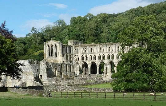
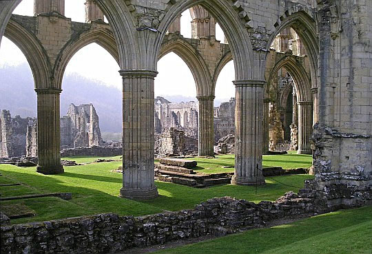
• Rievaulx Abbey. Een van de mooiste abdij-ruïnes van Groot-Brittannië.
• Men heeft er ook een
prachtig museumpje dat
laat zien hoe
de monniken toentertijd leefden. Warm aanbevolen.
Beste periode:
• Het zacht golvende heather moorland (heideveen) is rond de laatste week
van augustus een paars paradijs.
Dan staat de Struikhei maximaal in bloei. Dus dat is een heel geschikte periode.
• Kijk je echter alleen naar de temperatuur dan
zijn juni, juli, augustus de
beste
maanden.
• Neerslagcijfers vormen hier geen probleem. Het is nog wel upland, dus
hoger
dan grofweg 1,000 feet (ongeveer 300 m), maar toch niet erg
hoog
namelijk slechts ± 400 m
boven zeeniveau. En doordat je hier in de regenschaduw van de Pennines bent,
is het hier droger en
zonniger dan
de
westkant van Groot-Brittannië en zelfs
droger
en zonniger dan bijv.
Nederland.
(Voor het weerbericht ga je naar www.metoffice.gov.uk/ )
.Climate – Station Leeming (32m) |
apr |
mei |
jun |
jul |
aug |
sep |
okt |
.Gemiddelde maximumtemp. °C |
12
|
16
|
18
|
21
|
20
|
18
|
14
|
.Maandsom neerslag (mm) |
50
|
43
|
60
|
51
|
63
|
54
|
62
|
| (Gem. maximumtemp. De Bilt) | 14
|
18
|
20
|
23
|
23
|
19
|
15
|
Zwaarte:
Meeste dagen middelzwaar; één wandeldag is zwaar (zie verderop bij Van dag tot
dag).
• Voor het Heather moorland (heideveen) geldt:
Alleen dag 3 (Osmotherley - Clay Bank) is zwaar. Daar passeer je vier
moors gescheiden door kleine dalen en dat is telkens 100 - 150 hoogtemeters.
Een echte rollercoaster.
• Voor de kuststrook geldt:
1.
All the breaks
in the
cliffs (wooded coastal ravines (beboste kustkloven) and harbours). necessitating short drops and climbs over steep
steps.
2. High winds can make narrow sections of the clifftop path quite frightening.
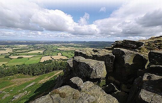
Cleveland Hills:
• The basic structure of the North York Moors is fairly simple with a series
of rock layers lying on top of each other and dipping down (= sloping
gently (zwak; flauw) . downwards) to the south.(Het is dus een cuesta).
• The Cleveland Hills form an arc that marks the boundary between the uplands of. the North York Moors and the lowlands of the Tees Valley.
(Uplands = gebieden grofweg hoger dan 1,000 feet (ca. 300 m) en lowlands lager dan 1,000 feet.)
• The softer stones underneath the harder sandstones ( Middle Jurassic Rocks)
are continually eaten away. This causes the hard rock to break off giving
an escarpment (=cuestafront). with
breathtaking views over the Tees Valley.
(The more massive sandstones give rise to a 300-metre escarpment (=cuestafront (Ned.), yet the dip slope is frequently of such a low angle that
the countryside resembles a dissected plateau (plateau doorsneden
door
rivierdalen), passing gradually on to the clay vale.)
• The Whitby Mudstone and Cleveland Ironstone beds have been the source .of mineral wealth in this area for centuries.
... Sandstone — As the name implies, sandstone is formed of sand that has
been turned to stone. Mudstone — Muds and silts that have been compressed to form a hard, fine-grained rock. Ironstone — A mudstone or sandstone with a high iron content. .... |
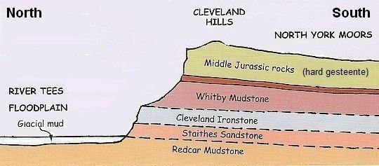
• De noordelijke escarpment (=cuestafront) van de Cleveland Hills vormt een abrupte scheiding
tussen het upland North York Moors en het lowland van de River Tees Floodplain.
• Je staat op de bovenrand van de noordelijke escarpment (= cuestafront) en kijkt naar het oosten.
• Helemaal links in de foto begint de voet van de escarpment op ongeveer 100 m boven zeeniveau.
• De harde zandsteenrots rechtsboven bevindt zich op ongeveer 400 m.
• Ook bij South Downs Way en Cotswold Way loop je bovenlangs
een escarpment (=cuestafront).
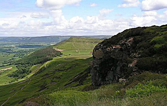
• The jagged (=getande), blocky Wainstones are on the sharp edge of the Cleveland Hills.
• Erosion has exposed the thick slab of sandstone that forms the cap of
the hills.
• As rain and wind wears away the soft shales (=kleischalies) underneath, huge square boulders break off.
(You can
see these boulders strewn around the lower slopes of the hills.)
• The view to the north over the
villages at the foot of the escarpment with Teeside in
the distance,
is breathtaking.
Routemarkering:
Zeer goed, zoals gebruikelijk bij "national trails".
Bevoorrading:
De dagen dat je langs de escarpment (=cuestafront) loopt, moet je
naar dorpjes
in
de vlakte afdalen voor voorzieningen. De route komt zelf maar
door één
dorp: Osmotherley.
Ik zou liever gezien hebben dat alle overnachtingsplaatsen in de
route waren opgenomen. Na uren lopen over heide met bijna continue prachtig
uitzicht,
zou
het toch geen probleem moeten zijn om tegen de avond over een "public
footpath" naar
een dorp aan de voet van het plateau te lopen, en de
volgende
morgen
via
een andere route weer omhoog. Dat komt ook de variatie ten goede.
• Levensmiddelen: (Zie o.a. het Food shop - symbool in je Harvey-kaart).
Sommige "Food shops" ("General stores") zijn zo klein, dat ze ieder moment gesloten kunnen worden. Vraag daarom altijd bij het verlaten van een dorp
of
de
volgende halteplaats nog wel een "Food shop" heeft.
• Drinkwater: zie o.a. het Toilets-symbool op je Harvey-kaart.
De veenstroompjes in het moorland zijn vervuild door schapenmest.
Daarom telkens
de
veldflessen in de dorpjes vullen.
(In geval van nood zoek je een hooggelegen veenstroompje met helder
water
en
kook je het).
ANWB Campings:
Zie voor een overzicht anwb.nl/engeland
Wildkamperen:
Een nachtje bivakkeren ('s avonds de trekkerstent opzetten en 's morgens
weer
afbreken) gaf geen problemen.
In het Nationaal Park is dat uitdrukkelijk verboden.
In het landbouwgebied er
omheen
zijn echter mogelijkheden genoeg.
Wil je ook langs de kust je tentje zetten, neem er dan een mee dat
behoorlijk
windvast is.
Hoogtepunten:
• Helmsley (and Helmsley Castle ).
• Rievaulx Abbey.(zeer mooie kloosterruïne)
• Mount Grace Priory, Osmotherley
• 'Red grouse' in the beautiful rolling heather moorland (golvend heideveen).
Kildale ― Slapewath .. (16 km) with:
• Captain Cook's Monument (walk here 25 meter to the west for a spectacular view along the Cleveland Hills)
• Roseberry Topping (uitzichtheuvel met rondom vrij zicht)
• Staithes ( famous old fishing village).
• Runswick Bay (beautiful hamlet and beach)
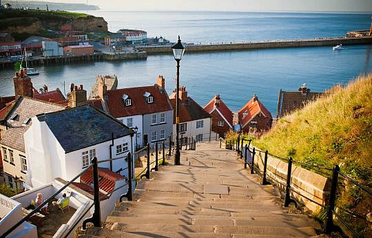
• Whitby (and Whitby Abbey , Captain Cook Museum )
Extra dag mogelijk in:
• Osmotherley:
With its neat stone cottages huddled around its green, ancient market cross
and
stone table where John Wesley preached during one of his sermon tours.
A lovely short walk from here visits the Lady Chapel and Mount Grace Priory,
an
attractive 14th century Carthusian monastery.
• Whitby:
It boasts an attractive harbour, atmospheric ruined abbey, Captain Cook
Museum,
Lifeboat Museum, Whitby Museum and St Mary's Church.
The interior of this intriguing church was altered in 1612 to resemble the
lower
deck of a wooden sailing ship.
Je kunt ook vanuit Whitby met de bus enkele uren naar Robin Hood's Bay
gaan.
Roseberry Topping: heuvel met uitzicht naar alle kanten.
Zo heet de geïsoleerde, erosiebestendige
heuvel achter op de foto.
Men noemt hem ook
wel de Mini Matterhorn van Yorkshire.Het
is een 'outlier', van de Cleveland Hills, d.w.z: a remnant separated from the Cleveland Hills escarpment (=cuestafront) by
erosion.
In het Nederlands: getuigeheuvel, d.w.z. een heuvel die getuigt van de
vroegere
ligging van het plateau en van haar latere terugschrijding.
This remarkable hill is the best-known landmark (=markant object) in
the lower Tees Valley.
The climb to the top gives spectacular 360 degree views over Teeside and
along
the Cleveland Hills.
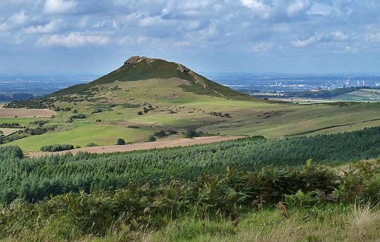
• Roseberry Topping with the well trodden path to the summit snaking its way up.
• Rechtsachter zie je Teeside-Middlesbrough (Je staat ten zuidoosten van Roseberry T.)
• Ook bij de Cotswold Way passeerden we zo'n getuigeheuvel, namelijk de Cam Long Down op de laatste dag
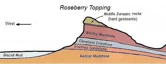
• A hard slab of sandstone sits on top of Roseberry Topping, while the soft
Whitby Mudstone is eaten
away from beneath.
• The hill also owes its shape to mining - ironstone on the lower slopes was dug out
in the past, leading to the collapse of one side of the hill.
| aaaa |
Limestone areas in England and Wales
• There are three types of limestone in the British Isles, but the one that
forms
the highest upland areas is Carboniferous limestone (1) (kalksteen uit
het Carboon).
• Links van de diagonale lijn liggen de uplands (=gebieden hoger dan ongeveer 1,000 feet (± 300m) boven
zeeniveau.) De belangrijkste upland limestone landscapes in Engeland zijn: Northumberland NP , Lake District NP , Yorkshire Dales NP , North York Moors NP en Peak District NP.
• Je ziet op de kaart dat North York Moors NP wel uplands is (het ligt links van de diagonale lijn), maar geen Carboniferous limestone (1) heeft, In plaats daarvan
heeft ze de zachte, geelachtige Jurassic limestone (2).
Deze Jurassic limestone vormt een 500 km lang massief tussen Lyme Regis aan de zuidkust en Whitby aan de noordoostkust.
Ook de Cotswolds hebben die zachte, geelachtige kalksteen, maar omdat ze ten oosten van de diagonale lijn ligt, is het dus géén upland.
The map shows the three sedimentary rocks that are made from sea
creatures:
1. Carboniferous limestone
(kalksteen uit het Carboon: hard, grijs),
2. Jurassic limestone
(kalksteen uit de Jura: zacht, geelachtig) and
3. Cretaceous chalk
(krijt uit het Krijt: zacht, wit) ,
Jurassic limestone (2) and Cretaceous chalk (3) can hold water – they have tiny holes in them
and are very porous.
Carboniferous limestone (1)
Carboniferous limestone is not at all porous — although it is permeable (=doorlaatbaar) Water seeps through the joints.
The limestone is laid down in layers or 'beds' separated by bedding
planes (laagvlakken) and divided up into blocks by a series of joints (vertikale scheuren) (Joint = een vertikale scheur in een gesteente zonder dat het gesteente aan beide zijden verschoven is.)
These Joints in rock are caused by shrinkage or release of pressure as rocks above are eroded away. (Zie verder upland limestone landscapes)
A long time ago, about 350 million years ago (even before the
Dinosaurs) England was covered by a
shallow tropical sea – a bit like
where the Great Barrier Reef is forming today.
As the small animals and corals that lived in the sea died, their shells and skeletons fell to the bottom. A thick layer built up over millions of
years.
As it squashed and hardened, it eventually turned into limestone.
This Carboniferous limestone (1) is nowadays found in:
- northern
England (e.g. Yorkshire Dales, Peak district),
- Wales (e.g. Brecon Beacons) and in
- Ireland (e.g. The Burren).
| aaaa |
Belangrijke cuesta's in Engeland:
.
The map shows two long curving almost parallel cuesta's.
• The western limestone/sandstone cuesta consists of:
Cotswold Hills + Lincoln Edge + North York Moors.
(The southern end of this winding cuesta forms the
peninsula of Purbeck Hills on the English Channel.
The more massive limestones and sandstones give rise to 300-metre escarpments (=cuestafronten), yet the dip slope is frequently of such a low angle that
the countryside resembles a dissected plateau ( plateau doorsneden
door
rivierdalen), passing gradually on to the clay vales.
• The eastern chalk cuesta consists of:
Chiltern Hills + Lincolnshire Wolds + Yorkshire Wolds.
(The southern end of this winding cuesta is on the Isle of Whight.)
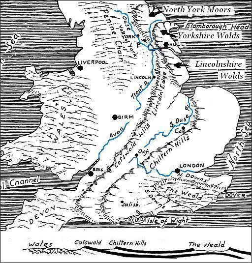
The cross section below the map shows the two relative hard layers
which form these two cuesta's.
These hard layers are separated from each other and also from the
underlying complex basement of older rocks by softer formations
of clays.
These clay beds underlie the two lowlands which form long belts just
west of the two cuesta's.
- Draining the western lowland are the rivers North Ouse, Trent and Avon.
- The eastern lowland is drained by the Southern Ouse, and the Upper . Thames. (This eastern lowland is known as the “Educational Lowland”, because it contains the cities of Oxford and Cambridge and other famous schools.)
The hard layers forming the cuesta's are limestone and sandstone beds.
The upper limestone bed which forms the Chiltern Hills is a chalk (krijt) formation , which comes out again in the South Downs and North Downs.
It also forms the “White Cliffs of Dover”
| aaaa |
Video: Rewilding (= herwildering)
with George Monbiot:
.
We zien een frappant verschil tussen de uplands in
continentaal Europa
en
die van Groot-Brittannië (en Ierland).
In het continent zijn ze bebost (denk bijvoorbeeld aan de Ardennen).
Dat zou de normale gang van zaken moeten zijn in de uplands met hun
ruige klimaat en arme
bodem.
In Groot-Brittannië zijn ze dat echter niet.
George Monbiot legt in een prachtige lezing uit hoe dat komt.
Warm aanbevolen www.youtube.com/watc.
George M.: The moors are the aftermath of repeated cycles of deforestation: cutting, burning and grazing and we call it moorland and
we believe
that it's the most magnificent state of nature there could
possible be
and
we invest vast resources in destroying other states of
nature in
order to keep it in this state of arrested development which has
almost
nothing there.
| aaaa |
HEATHER FAMILY (Heidefamilie):
Er zijn drie belangrijke soorten in de Heidefamilie:
De meest voorkomende heidesoort is:
1. Calluna vulgaris = Struikhei;
Drie namen in het Engels:
. Ling... (Common) Heather ... Scotch Heather
- ze heeft kleine, licht paarsrode bloemen.
- maximaal in bloei: rond de laatste week van augustus.
Ze behoort tot het Calluna-geslacht.
Kenmerken daarvan:
- bladeren bedekken elkaar dakpansgewijs,
- de plant kan wel 1 m hoog worden.
(Caluna betekent vegen. Men gebruikte haar takken voor bezems.)
Daarnaast zijn er nog twee belangrijke soorten in het geslacht Erica. Kenmerken daarvan zijn:
- bladeren staan in kransen.
- de plant blijft lager dan 60 cm.
2. Erica cinerea = Rode dophei (Bell Heather)
- paarsrode bloemen. Vallen onmiddellijk op door haar felle kleur.
- bloeitijd: vanaf begin juli. Begint dus al vroeger dan Struikhei te bloeien.
-
Bladeren in kransen van 3.
- staat op de drogere plekken.
3. Erica tetralix = Gewone dophei .(Cross-leaved Heath )
- roze bloemen.
- bloeitijd: iets later dan Rode dophei. Bloeit dus ook al vroeger dan Struikhei.
-
Bladeren in kransen van 4.
- staat op nattere plekken. (Het is geen "heathland plant", zoals de vorige twee, maar een "bogplant".)
(De Rode dophei is voor Nederlanders nieuw; de andere twee kennen we uit onze eigen heidevelden.)
- Struikhei is de belangrijkste soort langs de Cleveland Way.
- Rode dophei zag je aan de kust groeiend tussen de Struikhei.
- Gewone dophei is er wel aanwezig, maar niet langs deze route.
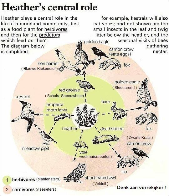
• Gentle rolling upland heathland) in the North York Moors National Park.
Het is heather moor = heideveen = met heide begroeide veengrond.
• Het wordt voor grouse shooting gebruikt.
• The heather moorland is upland (= land above upper limit of enclosed (omheind) farmland).
• Vuistregel: de Struikhei staat rond de laatste week van augustus maximaal in bloei.
| aaaa |
Enkele andere veel voorkomende planten in dit nationale park:
Blauwe bosbes Bilberry
Among the heath communities in addition to the heathers
(= heideplanten)
are
the so-called dwarf shrubs like bilberry.
It has a characteristic bloom (waslaag) on its black berry (ze is daardoor dofblauw berijpt).
The berry is gathered during July and August.
Bilberry is another of the plants which adapts well to the acid soils of
the
moors, and it is often found growing as an understorey among
the
heather.
Adelaarsvaren Bracken
As we leave the high moors and come down to lower ground, the first
plant which usually dominates the upper (= dryer) slopes of the dales is bracken.
Bracken generally grows in a band that lies above the uppermost line of
farm improvement and below the edge of the heather moorland.
Bracken is a fern, one of the flowerless plants that reproduce by spores,
not seeds. It spreads mainly by the growth of its creeping, underground rhizomes
(=wortelstokken). Bracken is widely recognised as a vigorously invasive
plant, potentially poisonous to animals and a financial wasteland
to hill farmers.
Some people regard it as Britain's worst weed (=onkruid).
| aaaa |
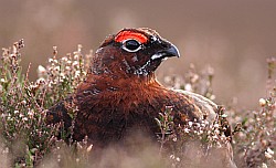
RED GROUSE on the gentle hills:
(Schots sneeuwhoen; (Lagopus lagopus scoticus)
"Go for a walk on the moors and
you will soon be knee-deep in purple
swaying heather,
where the whirr (= gesnor) of a flock of grouse flying
low and fast over the brow
of the hill is a lonely drama in a vast scene".
The moors have traditionally been managed to provide an ideal habitat
for
red grouse - a famous game bird..(shooting season starts the 12 th
of Aug.)
The upland heather is regular burned, creating a patchwork of - old heather which give cover for nests and camouflage for adults, and- fresh, young shoots which they feed on.
The lines of shooting butts are
reminder of the grouse shooting season.
(shooting butts are hides for shooting spaced some 20–30 m
apart,
screened by a turf or stone wall and usually sunken into the
ground to
minimise their profile) https://en.wikipedia.org/wiki/Dri
.
At close range, the males are seen to have a bold red comb (= kam) over the ey and
"pyjama" legs, which are covered in white feathers (Denk aan verrekijker!)
When disturbed, the grouse bursts noisily into flight with rapid wing
beats
and then flies over the moor in a series of low glides (= glijpauzes) and
whirring (= snorrende) flight at speed.
Seldom long in flight, it returns to ground with its clear call of go back, go back, back, back.........
There is no mistaking its warning to "get back ! "
Upland heathland is a semi-natural habitat.
It is natural in the sense that the plants which live there are natural
occurring
and not introduced or planted, but man-made in the sense that
man has excluded the trees which would
normally grow in such location.
In the absence of grazing by farm animals and deliberate burning,
scrub
and thereafter woodland would take over.
( upland = all land above the upper limit of enclosured (omheind) farmland.
Dit is grofweg het gebied hoger dan 1,000 feet ( ongeveer 300 m).
| aaaa |
SHEEP:
Moorland sheep must obviously be of a hardy breed 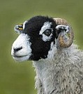 to withstand the rigours of the moorland winters.
The "Swaledales" with their black
faces and white
noses, are the most favoured breed.
Both sexes are horned,
the ewes have single-curved
horns, while the tups (rammen) have double- or
triple- curved horns.
Despite the lack of boundary fences, the flocks
keep
to their own strays (territories)
| aaaa |
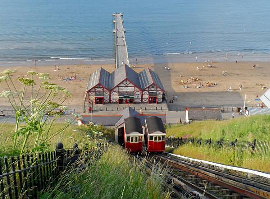
• The Saltburn Cliff Lift is a water-powered funicular (=kabelspoorweg).
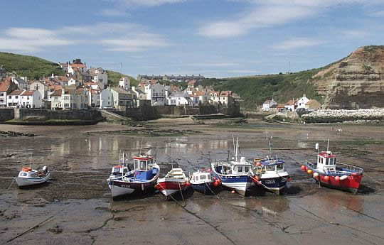
• The village of Staithes.
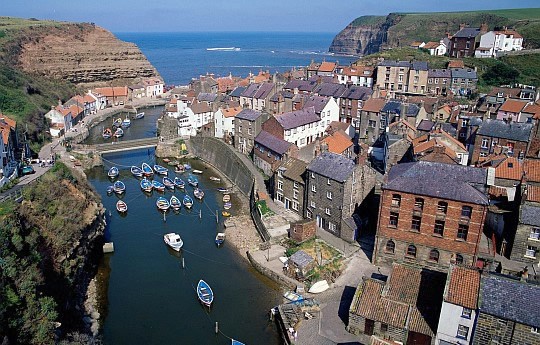
• The lovely little fishing harbour Staithes is associated with Captain Cook.
• A fleet of traditional coble fishing boats in the natural harbour and its houses huddled together.
• Staithes is built in the ravine cut into the high cliffs by Staithes Beck.
• Ze is met haar steep, narrow streets and colourful houses een van de schilderachtigste dorpjes. langs de kust.
Verrekijker gewenst:
1. Moorland birds:
The high moorlands provide nesting grounds for five bird species that are
worth
looking out for.
- The Red Grouse (Schots Sneeuwhoen) is the prime resident of the moors,
flying up suddenly when disturbed.
- The Merlin (Smelleken) is the smallest British bird of prey. You might catch
a glimpse of it twisting and turning in flight.
The other three: Curlew (Wulp), Lapwing (Kievit) and Golden Plover (Goudplevier) are waders, arriving on the moorland in the early part of the
year. These are glorious birds with fluty calls and extravagant flight displays.
Curlew and lapwing also occur around the margins of the Nationl Park.
2. Kuststrook:
In contrast to the big bird colonies on the chalk cliffs of Bempton and
Flamborough
to the south, there is comparatively little bird excitement
along
the dark cliffs, although gulls nest here and the fulmar(Noordse stormvogel) is
a common sight as
it patrols its breeding area.
- Fulmar = Noordse Stormvogel
(Fulmarus glacialis),
- Herring Gull = Zilvermeeuw
(Larus argentatus),
- Common Gull = Stormmeeuw
(Larus canus),
- Great Black-backed Gull = Grote Mantelmeeuw
(Larus marinus),
- Cormorant = Aalscholver
(Phalacrocorax carbo),
- Shag = Kuifaalscholver
(Phalacrocorax aristotelis),
- Common Tern = Visdief
(Sterna hirundo).
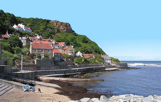
• The houses of Runswick Bay cling to the hillside at the northern end of a curved bay.
• Runswick Bay has the only stretch of sand along this part if the coast.
.
• Runswick Bay. Numerous paths
wind between the houses and their attractive gardens.
Zie voor een goede introductie van de uplands:
engeland_uplands
Zie voor een goede introductie van de verschillende kustvormen: engeland_coastal-landscapes
Brandingsplatform in je Harvey-strookkaart:
Daar wordt
het in de legenda coastal rock genoemd en donkergrijs
afgebeeld.
Langs de kust van de Cleveland Way
is dat
dus bijna overal
het geval.
Op zo'n brandingsplatform vind je naast rotsbodem ook los materiaal (zand,
grind,
rolstenen en schelpen).
Bij laagwater is dit een fantastisch recreatiegebied.
Hele gezinnetjes
met
emmertjes en schepnetjes struinen er rond.
"In the low-tide pools a wide range of marine creatures can be found".
Zandstrand:
Een enkele keer bevindt zich zacht gesteente op zeeniveau (bijv. bij Sandsend).
In dat geval ontstaat er geen brandingsplatform, maar een zandstrand (op de kaart: sandy beach, oranje).
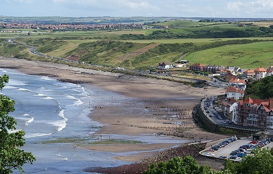
• Sandsend met haar zandstrand.
Whitby landslides:
Zie hiervoor:
www.bgs.ac.uk/landslide
Beware of unstable cliffs / falling rocks:
Het kustpad loopt grote stukken bovenlangs de klifrand.
Op een aantal plaatsen nadert de terugwijkende klifrand tot op een
meter
het pad.
Dit kan gevaarlijk zijn,
indien de klif op die plaats ondermijnd
is.
Het overhangende gesteente zou dan kunnen afbreken en omlaagstorten. Daarom geldt als regel: blijf boven op de klif op ruime afstand van de klifrand en beneden op het strand ver van de voet van de klif.
www.bbc.co.uk/news/u (Cornwall cliff collapse film)
Veel overblijfselen van vroegere mijnbouw:
From the 17 th to 19 th centuries ironstone, jet and alum mining transformed
the
landscape, leaving a host of industrial relics.
•ironstone = ijzerzandsteen (a type of sedimentary rock)
• jet = git,
• alum = aluin (a mix of potash and aluminium).
Most famously found around the Whitby area of North Yorkshire it has been
carved and polished to make jewelry since prehistoric times.
Whitby jet:
Jet is a black material similar to coal formed by the fossilisation of wood underhigh geological pressure.
Whitby lies at the heart of North Yorkshire's
Jurassic coast, a 7-mile slicethroughsedimentary
rock
formed when the dinosaurs waded through
tropical swamps
here.
The big beasts have gone but a glorious legacy
of
that age still serves the
town well. Whitby has
rich deposits of black jet, a substance that can be
cut and polished into elaborate items of jewellery.
Jet became a 'must have' accessory when Queen
Victoria took to wearing it after
the death of her
beloved Albert.
What hung around her neck were lumps of monkey puzzle tree, driftwood that
floated out to sea 180 million years ago when Whitby was much closer to the Equator, sank to
the
ocean
floor and after ages of being subjected
to great heat
and pressure
re-emerged
from
the rock laid down on the seabed
as jet.
Jet beads have been found in Bronze Age burial places. The shiny stone may
have
been worn to ward off evil spirits.
Eindbeoordeling:
Dit deeltraject is een echte top trail.
Beste websites:
www.clevelandway.co.uk
..........................................
www.northyorkmoors.org.uk
..........................................
www.ldwa.org.uk
(Sites komen en gaan; dat valt niet bij te houden.
Googel daarom ook een keer naar cleveland way en bekijk de eerste 10
(evt. 20)
resultaten.
Daar zitten de belangrijkste sites wel tussen.)
• Whitby is steeped in fishing and maritime history.
It has the remains of a 13th-century abbey and was once a leading whaling port, as well as being the base fot Captain James Cook's historic 18th-century voyages to the New world.
(Mooie documentaire
over Captain Cook vind je in de serie BBC Timewatch:
www.youtube.com/watch?v=-5
| aaaa |
Van dag tot dag volgens
www.sherpa-walking-holiday
A. Langs de westelijke plateaurand:
- The first part of the Cleveland Way through the North York Moors from Helmsley to Saltburn-by-the-Sea passes through woodland, lush green
dales and spectacular heather moorland (=heideveen).
- Around every corner lies something of interest; a ruined castle, an
ancient abbey, the White Horse of Kilburn, an old drove ‘road', a priory,
ancient stone markers and crosses, escarpments (cuestafronten) with far-reaching
views, traces of alum, jet and ironstone mining, prehistoric burial
mounds, or a grouse flying across
the path.
1. Helmsley ― Kilburn
......17½ km ..↑ 350 m ... Licht
- After your arrival in Helmsley, if you have not overnighted here it is
certainly worth a look round.
- Today is fairly easy so you could start at lunchtime from Helmsley's
Market Square and include a look at Rievaulx Abbey. (doen, zeer mooi ! )
- You could do also another detour (=zijstapje) to visit The White Horse of Kilburn, a lime stone horse carved into the hillside.
- You could stay for your first night in Kilburn or take the bus to Helmsley.
(In Sutton Bank is 'Bank' een synoniem van 'slope' en betekent dus
helling).
- Tijdens deze etappe zie je veel uitgezette Fazanten en Rode Patrijzen (gamebirds !). Ook zie je voerapparaten in het terrein.
Men zet hier Redlegs (Rode Patrijzen)
uit i.p.v. de inheemse.
Deze vogels uit Frankrijk zijn wat groter. Ze verdringen nu langzamerhand de Gewone Patrijs. Hier heb je dus hetzelfde verhaal als dat
van
de Grijze Eekhoorn die de Rode
verdringt.
2. Kilburn ― Osmotherley
.... 22 km ..↑ 250 m... Middelzwaar
- (Drinkwater voor de hele dag meedragen; de veenstroompjes op de
heide zijn vervuild door schapenmest.)
- If you have stayed the night
in Kilburn you will have a steep climb up
to regain the height you lost.
-
Today is more or less level walking along the escarpment (cuestafront) edge of the Hambleton Hills with views over the vale of York.
- You travel on a drover's road steeped in history.
(Drover's road (= Drift ) = ancient route, once used for bringing cattle
and sheep from
the farm to the market).
- There is little scope for refreshment until you drop down to Osmotherley. with
its quaint shops, cafes and three old pubs.
- Osmotherley is a fine old market town which grew as a green village
at a road junction. There is a Youth hostel , Mount Grace Priory, and
altogether it is a fine place to stop.
3. Osmotherley ― Clay Bank
...17½ km ...↑ 600 m.... Zwaar
- The section today is said to be the the hardest day of the entire route,
as you are ascending and descending over a succession of moors
to
Clay Bank.
- (Aantal pittige klimmetjes, o.a. over Cringle Moor (432 m; een echte
rollercoaster ! )
- You should have some excellent views once again to the agricultural
plains to the north west and the moors to the south east.
- You should bring all your own rations today, as there are few stops en
route.
- Important: "Clay Bank" is not a village or even a cluster of houses, it is
essentially a small car park.
( Het woord Bank is een synoniem van slope (=helling).
- There is no accommodation here. However there are a couple of
options..
About three quarters of a mile south is Maltkiln House, a B&B with
several rooms. This is easily walkable from Clay Bank.
The other option is to book a B&B in Great Broughton or Kirky, about
2 miles to the north of Clay Bank. An overnight stay in one of these
B&B will generally come with a lift to and from Clay Bank - but make
sure you ask before
booking.
4. Clay Bank ― Great Ayton
... 21 km ...↑ 450 m.... Middelzwaar
- This day is the most remote part of the Cleveland Way with no easy
access to facilities of any kind.(Veldflessen vullen voor de hele dag !)
-
Start the day with a steep ascent up onto Round Hill (454 m).
- (Vanaf 1 km ten westen van Round hill tot aan Middle Head top (zie je
Harvey-kaart) ben je op het hoogste gedeelte ( > 400 m) van de North
York Moors.)
- You are now walking on exposed high moorland, following the line of
the disused Ironstone railway line and drover's roads, with many
ancient features,
such as boundary stones, tumuli and cock pits before
descending to cross the remote hamlet and railway station at Kildale.
- (Ten westen van Bloworth Crossing kun je een stukje van de route
afsnijden door vanaf Cockayne Head over een pad en later via de Dismantled Railway rechtstreeks naar Incline top te lopen; zie je
Harvey strookkaart)
- Ascend again, passing the Captain Cook's Monument.
- (Loop hier 25 m naar het westen voor het mooiste uitzicht tot nu toe.)
- Your accommodation is in the Great Ayton area off route, so your final
distance today will
vary somewhat.
5. Great Ayton ― Saltburn
....17½ km ...↑ 450 m..... Middelzwaar
- The walk continues through forests and a diversion to Roseberry Topping, an outlying craggy hill, perhaps the supreme symbol of the Cleveland Way!
- (Deze 'Matterhorn' van Yorkshire (320 m) is dus een outlier. We hebben er
een prachtig rondzicht.
Hier komt de zee voor het eerst in beeld).
The views on a clear day are of course outstanding. Ga er even kijken !
- The trail follows more moorlands and then through the Guisborough
woods and steeply down to Slapewath, an area of old mineral workings.
- Perhaps fortify yourself with a pint here before continuing the last
4.5 miles to Saltburn-by-the-Sea.
-
This is an old fishing village; come small Victorian
seaside resort that was. once famed for salt making and smuggling!
-
The whole nature of the walk changes from here as you head off along
the. coast.
B. Langs de klifrand.
- The second part of the Cleveland Way from Saltburn-by-the-Sea to
Whitby, follows a rugged coast of high cliffs, wooded coastal gorges (=kustkloven) and sandy bays.
- Picturesque fishing villages with steep, winding streets and tightly
packed cottages and
-
the old whaling port of Whitby, with its imposing abbey, Captain
Cook
Museum and St Mary's Church whose interior was altered in 1612 to
resemble the lower deck of a wooden sailing ship, add to the charm
of this delightful walk.
6. Saltburn ― Runswick Bay
....19½ km....↑ 400 m..... Middelzwaar
- Walk along successive dramatic cliffs, past the highest cliff on the
east coast of England: Boulby Cliff (203 m) (Rock Cliff op je Harvey-kaart; ze ligt ten oosten van de hoge mast).
- One of the highlights of the walk is the beautiful fishing village of Staithes. (Dit betekent een afdaling naar zeeniveau ! ).
- The little fishing boats at the quay still set out to undertake this
dangerous activity.
- Captain Cook served his apprenticeship in a shop on the seafront
which has long ago, been stolen by the sea!
- The trail continues onto the red roofed attractive hamlet of Runswick Bay.
7. Runswick Bay ― Whitby
... 13 km ...↑ 300 m...... Licht
Quite a short day to give you the chance to have a good look round
Whitby (by = stad ).
- From Runswick Bay, there is another section of cliffs before reaching Sandsend,
-
from where you walk along above the beach to "Draculatown" Whitby.
-
This red roofed town (Het Noorse woord by betekent stad) grew rich
especially between 1750 and 1850 on fishing, whaling, jet mining and
shipbuilding.
Whitby is also famous for its Whitby Abbey ruins.
- Whitby is een stuk oorspronkelijker gebleven dan Scarborough.
Het heeft een oude binnenstad, mooie natuurlijke vissershaven de
abdijruïne en het Captain Cook Museum.
Voor de kilometers ten zuiden van Whitby geldt:
• Het traject Whitby ― Robin Hood's Bay is ronduit zwak.
• Robin Hood's Bay zélf is heel schilderachtig en romantisch, maar daar
kom je ook al
tijdens de Coast to Coast Walk.
• Na Robin Hood's Bay wisselen goede en zwakke gedeelten elkaar af.
Dit samengenomen deed me besluiten de route te eindigen in Whitby. ....
| aaaa |
SNP Natuurreizen heeft hier ook een wandelreis:
Zie : www.snp.nl/reis/groot-
| aaaa |
..... Wandelgids: The Cleveland Way: With Yorkshire Wolds .....  Strookkaart: Strookkaart:
Harvey Maps 1: 40,000
Harvey strip maps (strookkaarten) zijn de beste kaarten. Te bestellen bij: Reisboekwinkel de Zwerver ( webshop voor reisgidsen en landkaarten) .... |
..Deze wandelsite is niet-commercieel, onafhankelijk en gratis. Dat is enkel mogelijk door steun van de bezoekers. Uiteraard kun je ook doneren door overschrijving op mijn |
| aaaa |
Reactie van Bart:
Beste Piet,
Graag stuur ik u een mailtje om u te bedanken voor uw fantastische
website. Vorig jaar wandelden we de Malerweg en deze zomer de Cleveland Way.
Onze keuze hebben we twee keer bepaald door wat we op de site lazen
en
twee keer was het een voltreffer.
Nogmaals dank om al die info ter beschikking te stellen.
We kijken al uit naar een volgende tocht (misschien Le chemin de
Stevenson).
Met vriendelijke groet
Bart
Gent-België
| aaaa |
Weet je aanvullingen en verbeteringen van deze tekst?
Graag een e-mail naar:
![]()
![]() ....
.... ![]() .....
.....![]()
LAATST BIJGEWERKT : 7-1-2019