...
..................SOUTH. EAST. ENGLAND
| ..BRITAIN'S FAVOURITE WALKS TOP100 ― SOUTH EAST.ENGLAND |
• 99 betekent: de wandeling eindigde op de 99ste plek in Britain's Favourite Walks: Top 100.
• Klik je op dit nummer 99 in de kaart, dan word je doorverbonden met kader 99 hieronder.
• Lichtbruin = National Park. Dit zijn: New Forest NP en South Downs NP.rest National
• Lichtgroen = AONB (Area of Outstanding Natural Beauty).(the next step down from a National Park).
| aaaa |
13
13. South Downs Way..South Downs N.P.
langeafstandspad . middelzwaar
(Een 13e plaats in de TOP 100 lijkt mij veel te veel eer voor dit langeafstandspad ! Een plek ergens boven de 50 is beter)
This long-distance walking route follows the old drovers paths along
the
high
ground
of the Downs between Winchester and Eastbourne.
It is accessible along its length, with no
stiles to clamber over.
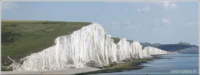
Highlights include The Seven Sisters, Beachy Head, Devil's Dyke,
Jack and Jill Windmills, Ditchling Beacon and Chanctonbury Ring.
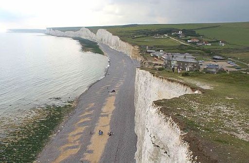
• Het aktieve krijtklif bij het gehucht Birling Gap.
• Het behoort tot de top-10 kwetsbare plekken kustafslag in Groot-Brittannië.
Langs dit deel van de Engelse zuidkust wint de zee gemiddeld liefst 70 cm per jaar aan terrein.
• Chalk (=krijt) is generally considered a soft rock, but it is surprisingly resistant to marine erosion and
forms towering vertical cliffs along the coast.
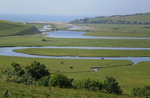
• Het Cuckmere-dal is één van de vier doorbraakdalen.
• The River Cuckmere is tidal up to four miles upstream, and, as a result, is a good place for bird watchers with its range of habitats including coastal lagoons.
• De rivier de Cuckmere meandert over de brede, vlakke dalbodem naar zee.
• Meanders are natural bends formed as a river flows across its floodplain (overstromingsgebied).
• Deze foto toont de kenmerken van een rivierdal in z'n benedenloop:
1. zéér breed dal (overstromingsgebied),
2. grote meanders (en ook afgesneden meanders).
(Alleen het derde kenmerk (de oeverwallen) zijn op deze foto niet zichtbaar.)
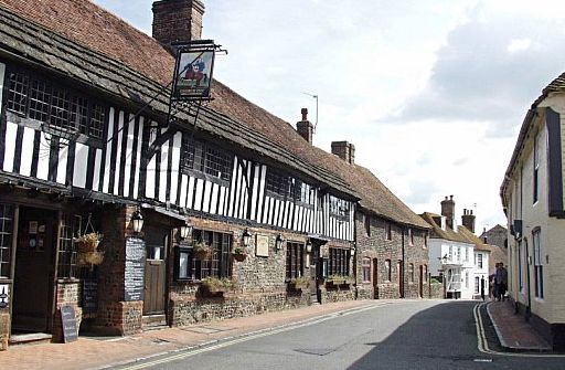
• The George Inn and High Street, Alfriston.
• Er zijn mooie vakwerkgebouwen in dit prachtige dorp.
streetmap.co.uk
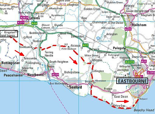
Enkele mooie dagetappes:
1. Kingston-near-Lewes ― Alfriston .....19 km
2. Alfriston ― Eastbourne ..... 20 km
Zie hiervoor : www.contours.co.uk
• One of the most dramatic sections of the entire trail is this
Eastern Section Short Break.
• It travels through quiet valleys and across breezy
open spaces, surrounded
by big views.
• The trail straddles the ridge of the escarpment (steilrand) to the
village of Alfriston, famed for its ancient buildings, and
winds through Friston Forest.
• Dramatic coastal views crown the route at Birling Gap, Seven Sisters Cliffs,
and Beachy Head.
ANWB Campings:
Zie voor een overzicht anwb.nl/engeland
Wildkamperen (bivak):
Gaf mij geen problemen.
Zie ook:
www.pietsmulders.nl/...
Wandelgids: Kaart: Te bestellen bij: Reisboekwinkel de Zwerver ( webshop voor reisgidsen en landkaarten) |
| aaaa |
29
29. The Needles.Isle of Wight AONB
7 ½ km.... middelzwaar
(Het lijkt mij eerder een lichte wandeling)
(Een 29e plaats in de TOP 100 is te veel eer. Ze hoort m.i. ergens tussen de 75 en 100 te eindigen.)
This is one of Britain’s most iconic walks, visiting the world-famous
chalk stacks (brandingszuilen, klippen) of the Needles and their
historic lighthouse on the Isle of Wight.
The Needles are a row of three distinctive rocks on the western tip of
the Isle of Wight that attract walkers
all year round, and this route
explores the beautiful downlands surrounding them.
You’ll also pass a monument to the Victorian poet laureate Alfred Tennyson,
a Cold War rocket test site and a 19th century fort along the way, making
this an action-packed walk despite its relatively
short 7½ km length.
Most of this circular route follows gently undulating downlands and
cliff-tops, with a steep ascent or descent to Tennyson’s Monument depending on which way you walk.
Don’t forget your camera, because the views are mind-blowing.
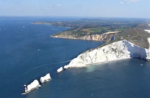
• De drie sea stacks bestaan uit een harde krijtband die veel weerstand biedt aan erosie.
• In de opening ertussen stond vroeger ook nog een 'Needle', maar die viel om in 1764.
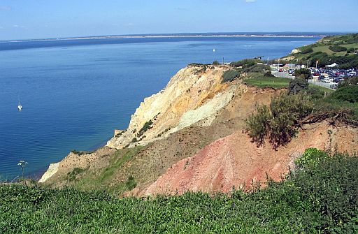
• Alum bay with its coloured cliffs is a busy spot with a chairlift down to the beach, but it is a quick walk down and
back for the walker!
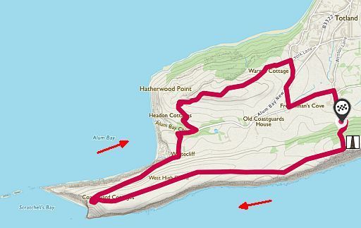
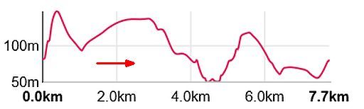
Totale stijging 240 m.
Start / finish: Yarmouth
ANWB Campings:
Zie voor een overzicht anwb.nl/engeland
Wildkamperen (bivak):
Gaf mij geen problemen.
Verdere info:
www.nationaltrust.org.uk/th
.............................................
https://osmaps.ordnancesur
Zie voor een goede introductie van de verschillende kustvormen:
engeland_coastal-lands...
Wandelgids: Kaart: Te bestellen bij: Reisboekwinkel de Zwerver ( webshop voor reisgidsen en landkaarten) |
| aaaa |
46
46. The Ridgeway
langeafstandspad ......middelzwaar
This long-distance walk follows the ancient track of The Ridgeway –
often described as Britain’s oldest road – through the North Wessex Downs and
the Chilterns.
Running from West Kennett in the south to Ivinghoe Beacon in the north,
The Ridgeway passes through ancient landscapes of downland,
secluded valleys and woodlands on a route used since prehistoric times
by travellers, herdsmen and soldiers.
You’ll be treated to wide-reaching views over rolling hills and pass many important archaeological monuments, including the world-famous Uffington White Horse and Avebury standing stones.
The Ridgeway can be walked quite comfortably in six days, so it’s a
great adventure to pack into a week, and passes through or close to
many pretty villages and small towns that are perfect for overnight accommodation or refreshment stops.
FOTO
FOTO
KAART
PROFIEL:
...............................................
Start:
Finish:
Verdere info:
Wandelgids: Kaart: Te bestellen bij: Reisboekwinkel de Zwerver ( webshop voor reisgidsen en landkaarten) |
| aaaa |
72
72. Leith Hill .Surrey Hills AONB
14 km ...... middelzwaar
You’ll walk through a mixture of woodland, heathland and farmland and visits Leith Hill Tower – the highest point in south-east England –
with
magical views across a landscape that inspired Charles Darwin.
Leith Hill is the highest point (294 m.a.s.l.)
in South East England.
From the tower ( just more than 1,000 feet (305 m) you can see
sweeping views towards
London in the North and the English Channel
in the South.
The walk takes in charming Surrey mill hamlets, hammer ponds and
the
gothic folly at the top of the hill.
There are many possible routes. This circuit gives a great tour of the
area.
Leith Hill is set in an AONB (Area of Outstanding Natural Beauty) and
home
to an abundance of stunning wildlife.
There are primroses and bluebells to marvel at in spring.
Keep your eyes on the skies as you walk, with red kites, buzzards and
goshawks all common at Leith Hill.
Butterflies are abundant in the summer months too – with the wooded
glades home to commas, purple emperors, white admirals and
silver-washed fritillaries.
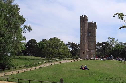
• Leith Hill Tower is a 19.5 m high folly on the summit of the
highest
point (294 m) in South East England.
• It was built with the intention of raising the hill above 1,000 ft (305 m) above sea level.
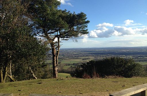
• View from top of Leith Hill.
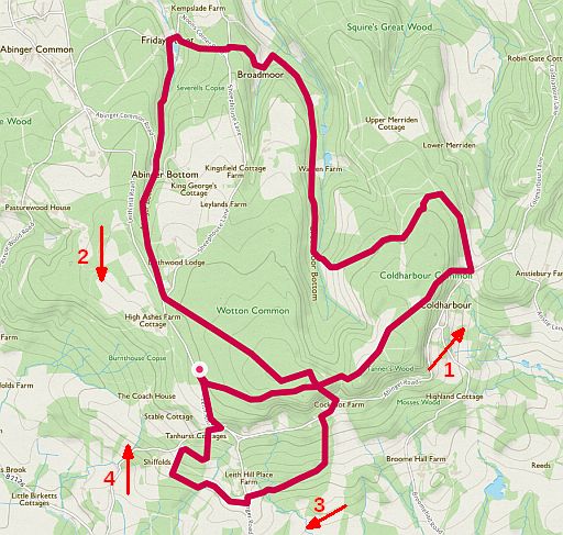
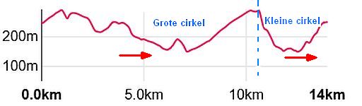
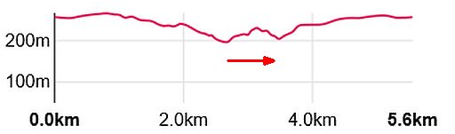
Totale stijging ± 440 m.
Start / finish: Starveall Car Park, Leith Hill Road.
ANWB Campings:
Zie voor een overzicht anwb.nl/engeland
Wildkamperen (bivak):
Gaf mij geen problemen.
Verdere info:
https://osmaps.ordnancesu
Wandelgids: Kaart: Te bestellen bij: Reisboekwinkel de Zwerver ( webshop voor reisgidsen en landkaarten) |
| aaaa |
75
75. Great Missenden Chiltern Hills AONB
15 ½ km ...... lichte wandeling
This 15½ km walk starts in Great Missenden and climbs to the summit
of Coombe Hill, the highest viewpoint in the picturesque Chiltern Hills.
The Roald Dahl museum is based near the start of the walk in Great Missenden, which is the village where the legendary author lived and
wrote
for 36 years.
Classic children’s stories including Matilda and Danny the Champion
of the World were inspired by the landscape and countryside of
Great Missenden
and the Chilterns, making this a fascinating route from
start to finish.
As you climb steadily towards Coombe Hill’s 260-metre high point and
its spectacular monument, views open up across the Aylesbury Vale,
rare
chalk grasslands and beautiful woodlands.
Other highlights include the pretty village of Ellesborough and the
Prime Minister’s country retreat at Chequers.
The walk is rolling and undulating rather than steep and challenging.
• Roald Dahl Museum and Story Centre, Great Missenden.
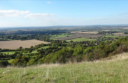
• Overlooking the Vale of Aylesbury from Coombe Hill on the Chiltern Escarpment.
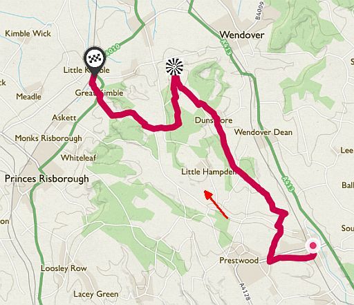
Great Missenden Station - Dunsmore -
Coombe Hill - Chequers -
Great Kimble -
Little Kimble Station.
Start: Great Missenden Station
Finish: Little Kimble Station
ANWB Campings:
Zie voor een overzicht anwb.nl/engeland
Wildkamperen (bivak):
Gaf mij geen problemen.
Verdere info:
https://outoftheloopdotcom.
.............................................
https://osmaps.ordnancesur
Wandelgids: Kaart: Te bestellen bij: Reisboekwinkel de Zwerver ( webshop voor reisgidsen en landkaarten) |
| aaaa |
76
76. Devil's Punch Bowl.Surrey Hills AONB
5 ½ km ......... middelzwaar
The National Trust properties at Hindhead, principally the Devil’s Punch Bowl and Hindhead Common, were some of the first
open spaces acquired by the National Trust in 1906.
Unfortunately for many years Hindhead Common was separated from
the Devil's Punch Bowl by the A3 trunk road.
However, since the opening of the A3 Tunnel the two sites have been
re-united and now comprise over one thousand acres of some of the
most spectacular open space in Britain.
The higher ground of the Devil's Punch Bowl’s magnificent horseshoe-shaped valley is dry sandy heath.
The valley, which is the largest spring-sapped valley in Europe,
was formed
by erosion from a series of springs (bronnen) which now
feed Smallbrook stream.
We know that the valley floor has had a small field system since
Saxon times.
Hindhead Common is dominated by Gibbet Hill the second highest
point in Surrey with great views of the Weald.
At 892 feet it affords
spectacular views North, East and South.
Much of it is open heathland but there is an area of woodland at
Hurt Hill on the south-eastern flank, some of which is coppiced (gekapt als hakhout) .
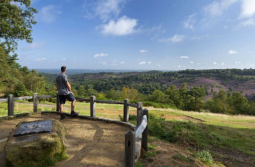
• The higher ground of the Punch Bowl’s magnificent horseshoe-shaped valley is heathland.
• The valley, which is the largest spring-sapped valley in Europe, was formed by erosion from a series of springs which now feed Smallbrook stream.
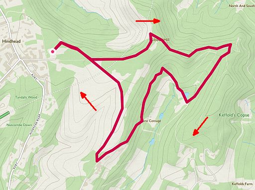
Totale stijging ± 160 m.
Start / finish:Hindhead.
ANWB Campings:
Zie voor een overzicht anwb.nl/engeland
Wildkamperen (bivak):
Gaf mij geen problemen.
Verdere info:
http://haslemere-nt.com/
........................................
https://osmaps.ordnanc
Wandelgids: Kaart: Te bestellen bij: Reisboekwinkel de Zwerver ( webshop voor reisgidsen en landkaarten) |
| aaaa |
80
80. White Cliffs of Dover
Kent Downs AONB
16km ...... lichte wandeling
This 16 km walk along the White Cliffs of Dover explores the fascinating scenery, wildlife, history and geology of one of Britain’s most iconic landscapes.
Starting in the busy port of Dover and finishing in the beautiful
seaside
town
of Deal– which sits on the border of the English Channel
and the North Sea – this is a classic coastal route with forever-changing
views that stretch to
France on a clear day.
With Dover Castle near the start and Henry VIII’s fortresses of Walmer Castle and Deal Castle near the end, it’s a route brimming with history.
You’ll pass shipwrecks and wartime memorials as you walk, with some
steep up-and-down sections leading past lighthouses, bays and glorious
cliff-top viewpoints.
In summer the rare chalk grasslands come alive with birds, butterflies
and wildflowers.
This is quite a long, linear walk that’s flanked by steep drops, so take
care
and make sure you stick to the marked coastal path.
Your reward for completing the route will be visits to three of England’s mightiest sea forts, and panoramic views across one of the world’s
most famous stretches of coastline.
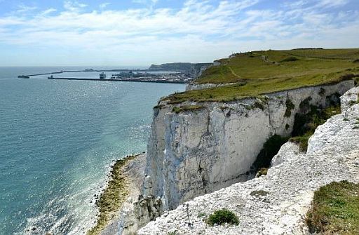
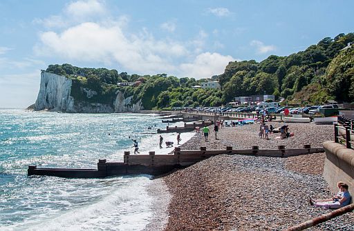 • St Margaret's Bay.
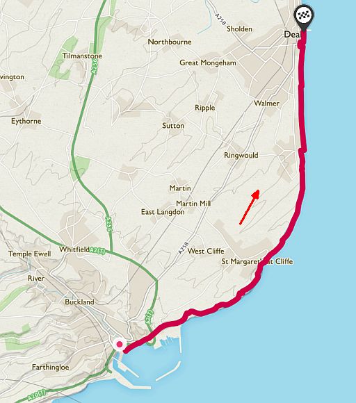
Start: Dover: Carpark National Trust, Upper Rd, Guston, Dover
Finish: Deal....T16 1HJ
Zie voor een goede introductie van de verschillende kustvormen:
engeland_coastal-lands...
ANWB Campings:
Zie voor een overzicht anwb.nl/engeland
Wildkamperen (bivak):
Gaf mij geen problemen.
Verdere info:
http://happyspooner.com
........................................
www.englandcoastpath.com
Wandelgids: Kaart: Te bestellen bij: Reisboekwinkel de Zwerver ( webshop voor reisgidsen en landkaarten) |
| aaaa |
89
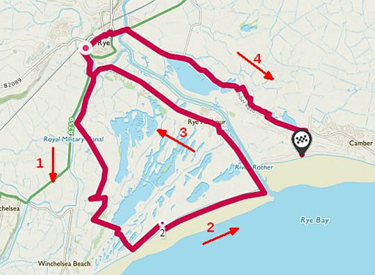
89. Rye Harbour and Camber Sands
Rye Harbour Nature Reserve
17 ½ km .... lichte wandeling
Beaches, lagoons, castles, reedbeds and magnificent wildlife.
You’ll be amazed what you can pack into one short coastal walk.
This walk explores Rye Harbour Nature Reserve and its amazing wildlife before finishing at Camber Sands beach on the stunning Sussex coast.
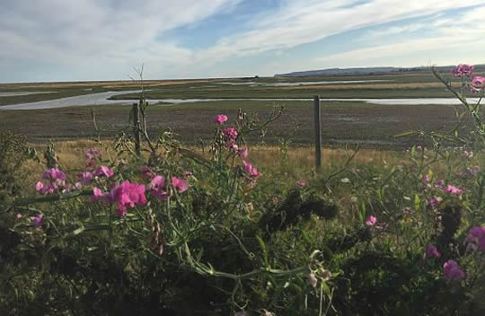
Rye Harbour is one of the most important conservation sites in Britain, due to its many coastal habitats including shingle, saltmarsh,
saline
lagoons, coastal grazing marsh, freshwater gravel pits and
reedbeds.
With its ever-changing coastline and fascinating military history, this is
a wonderful place to walk and lose yourself among the sights and
sounds of wildlife.
Rye Harbour is famous for its breeding colonies of little, common and Sandwich terns; and is a great place to spot ringed plovers, avocets, oystercatchers, redshanks, lapwings and wheatears.
Marsh frogs, badgers, foxes and bats are just some of the other species
that call this Site of Special Scientific Interest home.
This route follows miles of footpaths across the reserve and visits Camber Castle, which was built by Henry VIII and designed to protect
the
port of Rye from foreign invaders.
You then have the option to finish your walk where you started in Rye, or extend the route by strolling down to Camber Sands, a stretch of sand
backed by massive dunes. We highly recommend the latter!
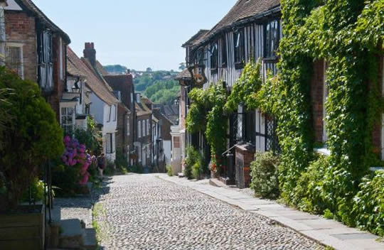
• Perched on a hill above the surrounding mysterious Romney Marshes, Rye is one of the most picturesque towns in England, with hilly cobbled streets and timbered houses.
• It stands near the mouth of the River Rother, two miles inland, but was one of the original Cinque Ports before the sea withdrew and the harbour silted up in the 16th century.
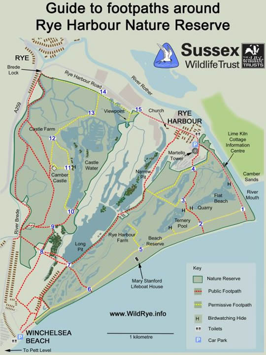
• The Rye Harbour Nature Reserve has a network of foot paths that allow the reserve to be visited.
• Within the reserve there are five hides giving the visitor wonderful views of the
wetland wildlife.
• The Reserve has many habitats which include wetlands, shingle ridges ( kiezelwallen),
sand, marsh and woodland.
• This is home to a wide range of species, a hundred and fifty of which are considered
rare or endangered in Britain.
• The information centre at Lime Kiln Cottage is open most days from 10am - 4pm.
Start: Rye
Finish: Rye or Camber
ANWB Campings:
Zie voor een overzicht anwb.nl/engeland
Wildkamperen (bivak):
Gaf mij geen problemen.
Verdere info:
https://sussexwildlifetrust.org.uk
.....................................................
https://osmaps.ordnancesurvey.
Wandelgids: Kaart: Te bestellen bij: Reisboekwinkel de Zwerver ( webshop voor reisgidsen en landkaarten) |
| aaaa |
99
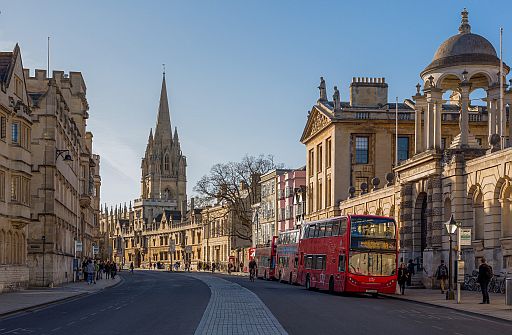
99. Oxford City Walk
4km .... lichte wandeling
Oxford is a fascinating city to explore on foot, with its world-famous university, beautiful architecture, rich history and iconic movie locations.
This urban walk takes in some of Oxford’s most treasured and popular sights, including the Bridge of Sighs (not to be confused with its namesakes in Cambridge and Venice), the 18th century Radcliffe Camera building and the Bodleian Library – one of the oldest of its kind in Europe.
You’ll pass prestigious university colleges and enjoy stunning views of the ancient spires and domes that make up Oxford’s historical skyline.
Fans of the Harry Potter movies will be keen to catch a glimpse of some of the movie franchise’s famous filming locations, which include New College, Christ Church College and the Bodleian Library that doubled up as the library at Hogwarts.
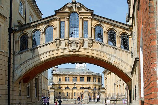
• The Bridge of Sighs.
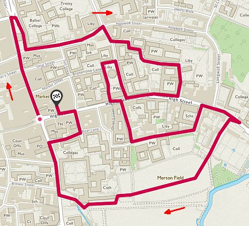
Start
Finish:
ANWB Campings:
Zie voor een overzicht anwb.nl/engeland
Wildkamperen (bivak):
Gaf mij geen problemen.
Verdere info:
https://osmaps.ordnancesur
Wandelgids: Kaart: Te bestellen bij: Reisboekwinkel de Zwerver ( webshop voor reisgidsen en landkaarten) |
| aaaa |
100
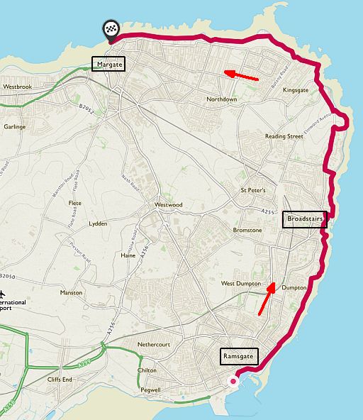
100. Ramsgate–Margate.
13 km .... licht... (coastal walk)
Dramatic coastal scenery, historic towns, bloodthirsty Viking history and Charles Dickens’ favourite walks – all wrapped up in this stretch of coastline.
This 13 km coastal walk links the towns of Ramsgate, Broadstairs and Margate along the cliffs and beaches that characterise the Viking Coastal Trail in Kent.
For much of the walk you’ll stroll along low chalk cliffs that deliver
dramatic, sweeping cliff top views across the English Channel.
This cliff-top walking takes place with a luscious
carpet of grass
beneath your feet.
You can also walk along the beach and explore hidden coves if the
tide is out.
There are beautiful chalk rock formations to discover.
All three historical coastal towns have their own personalities and
charms
with :
1. Ramsgate: an interesting old town and harbour,
2. Broadstairs: with its strong links to Charles Dickens who frequently visited and walked here along Viking Bay, and
3. Margate: seaside town with a sweeping harbour.
This whole walk takes place on the Isle of Thanet, which is where the Vikings first landed in Kent, and the route between Ramsgate and
Margate largely follows the Viking Coastal Trail.
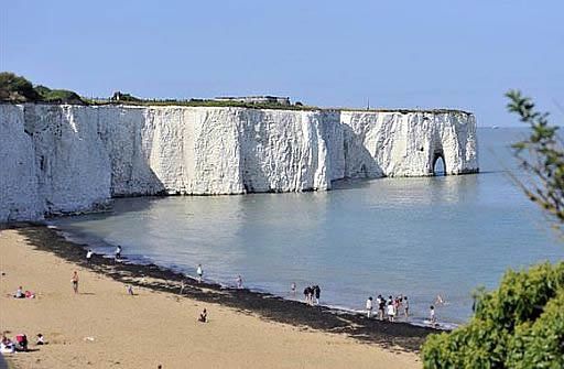
• Chalk (=krijt) cliffs and sea arch (=brandingsboog ) at Kingsgate Bay.
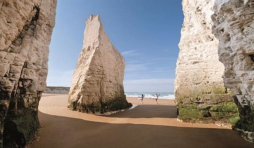
• Pillars (=brandingspilaren) of chalk isolated from main cliff at Botany Bay.
Start: Ramsgate.
Finish:Margate.
ANWB Campings:
Zie voor een overzicht anwb.nl/engeland
Wildkamperen (bivak):
Gaf mij geen problemen.
Verdere info:
www.ramsgatetown.org/upload/
....................................................
www.walkingclub.org.uk/walk/r
...................................................
https://osmaps.ordnancesurvey
Zie voor een goede introductie van de verschillende kustvormen:
engeland_coastal-lands.
Wandelgids: Kaart: Te bestellen bij: Reisboekwinkel de Zwerver ( webshop voor reisgidsen en landkaarten) |
| aaaa |
..Deze wandelsite is niet-commercieel, onafhankelijk en gratis. Dat is enkel mogelijk door steun van de bezoekers. Uiteraard kun je ook doneren door overschrijving op mijn |
Weet je aanvullingen en verbeteringen van deze tekst?
Graag een e-mail naar:
![]()
..![]() ....
.... ![]() ...
...![]()
LAATST BIJGEWERKT : 7-1-2019